Cloud, rain and thunderstorms are expected to impact a large area of Australia this week, as a northwest cloudband and low-pressure system sweep across the country.
Northwest cloudbands are vast layers of cloud which stretch from Australia’s northwest to southeast. They form when humid and warm tropical air over the Indian ocean moves across Australia, producing cloud as the air rises over the cooler air in the mid-latitudes.
The oceans off the northwest shelf of Australia are currently warmer than average, contributing humidity and warmth into our atmosphere.
In this week’s case, the northwest cloudband is set to interact with a low-pressure system, producing thick cloud and heavy rainfall over much of northwestern, central and southeastern Australia.
Central Australia will not miss out, as the northwest cloud band sweeps across the interior.
Northwestern, central and southeastern Australia are expected to see widespread totals of 10-30mm during the next week. Parts of the Kimberley and Pilbara and far southwestern WA could see 30-50mm, falling during the next few days (figure 1).
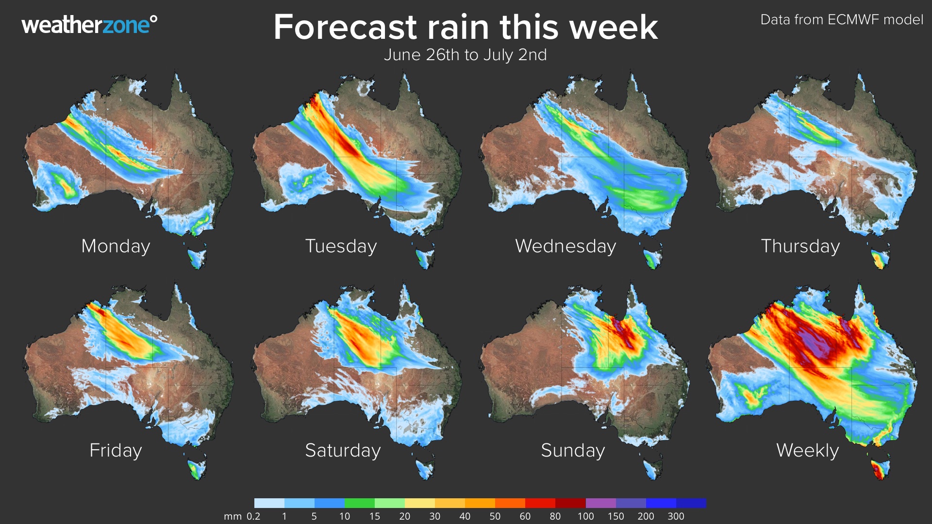
Figure 1: ECMWF weekly accumulated rain totals across Australia.
The Snowy Mountains and VIC alps are predicted to see weekly totals of 60-80mm, with isolated pockets of 80-100mm (figure 1). The snow level is expected to drop from Wednesday, with much of this rainfall expected to be falling as snow.
This slow-moving and broad system will produce areas of intense rain and thunderstorms and potentially damaging winds across southeastern Australia later this week.
Today, much of the rainfall through inland parts of the Pilbara and the Kimberley region is falling out of ground-based radar range (figure 2). However, our synthetic radar system, Oracle, is picking up the extensive rainfall in the eastern Pilbara, Kimberley and Interior (figure 2).
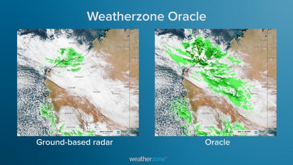 Figure 2: Ground based radar versus Oracle radar at 9:38am WST June 21.
Radar coverage is sparse across regional Australia, much to the frustration of miners and local communities.
This is because radars are typically placed near the coast, where much of Australia lives. Unfortunately, they can only detect rainfall within a 256-kilometer radius, leaving many areas without coverage.
Weatherzone has the solution, and its name is Oracle.
Oracle is a new ‘radar’ system, which enables users to see rain as it’s happening anywhere in the world. In addition to tracking current rain, Oracle also provides live forecasts of rainfall rates, lightning, and cloud for up to three hours in advance, for anywhere in the world.
It does this by feeding live satellite imagery, lightning data and nearby radar imagery into the forecast system. This cutting-edge technology was built in collaboration with Solcast.
Oracle is a more than adequate replacement for radar, but the genius of it is that it’s also a one-of-a-kind forecast system, delivering accurate forecasts out to four hours.
Stay tuned for additional updates on Oracle’s new forecasting capabilities. For more information, please contact us at apac.sales@dtn.com.


