Heavy rainfall, strong winds and severe thunderstorms are all on the cards for parts of SA, VIC, TAS and NSW as a low-pressure trough moves over southeastern Australia.
On Saturday the trough will generate rain and storms across southeastern Australia. Daily rainfall totals are expected to reach 20-30mm in parts of southern SA and NSW on Saturday (figure 1).

Figure 1: ECMWF 24- hour rainfall totals on Saturday November 20.
On Sunday and Monday, the models are still struggling to figure out where the low will move on, which will determine exactly where and how much rain falls in what regions.
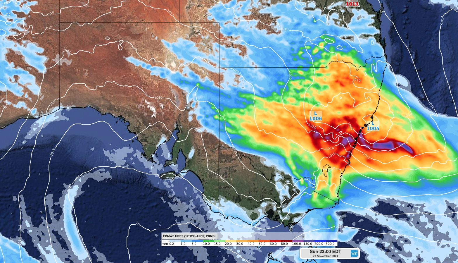
At this stage, on Sunday, a low-pressure system is expected to form within this trough in NSW, enhancing rainfall, storms and winds in the region. Widespread rainfall is expected across much of NSW and eastern VIC on Sunday, with daily rainfall totals of 15-35mm on the forecast. While areas near and on the southern flank of the low could see 24- hour rainfall totals reaching 50-100mm, particularly in thunderstorms (figure 2).

Figure 2: ECMWF 24- hour rainfall totals on Sunday November 21.
As the low-pressure system deepens strong and gusty winds are expected on Sunday in parts of NSW, QLD and VIC. Damaging wind gusts are possible in thunderstorms that are triggered on Sunday by the low (figure 3).

Figure 3: ECMWF wind gusts at 2pm EST on Sunday November 21
On Monday, the rain and thunderstorms will focus on eastern Australia, as the low-pressure system moves east into the Tasman Sea. Widespread 24-hour totals are forecast to reach between 5-20mm on and east of the Great Divide. Pockets of 30-60mm are likely on Monday in central and northern NSW and southeastern QLD, particularly in showers and storms (figure 4).

Figure 4: ECMWF 24- hour rainfall totals on Monday November 22.
Strong and gusty south to southeasterly winds is expected on Monday along the southern flank of the low, in eastern NSW. Damaging wind gusts are likely in thunderstorms on Monday in these areas as well (figure 5). The weather should ease for NSW on Tuesday and QLD on Wednesday, as the low moves further east in the Tasman Sea.

Figure 5: ECMWF wind gusts at 8am EST on Monday November 22.
While eastern Australia prepares for wet, windy, and cool conditions when the low approaches the area, warm temperatures are forecast for QLD from Friday.
Brisbane is forecast to see a run of 4 days above 30 degrees from Saturday, before the cooler southeasterly change arrives on Tuesday. Monday is likely to be the hottest day for Brisbane, with the daytime temperatures forecast to reach 33C.
As this system evolves, please keep an eye on the latest warnings and forecasts. For more information, please contact us at apac.sales@dtn.com.


