Prosper in a dynamic world
Search

It could rain in every capital city this week


Several rain-bearing systems aligning over Australia this week could see rain falling in the official gauge of every state and territory capital city. 

Australia’s eastern and southeastern states will be doused by several days of rain and thunderstorms this week as a slow-moving upper-level low pressure system interacts with abundant tropical moisture. 

This system is likely to see some rain falling in Adelaide, Melbourne, Hobart, Canberra and Brisbane between Monday and Friday. 

While that is all going on the in the east, a series of cold fronts will bring rain, storms and blustery winds to southwestern Australia between Wednesday and Sunday. Perth should pick up rain on a few days from these systems and Adelaide might even get a drop or two on Sunday. 


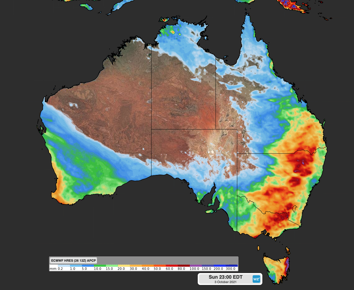
Image: Forecast accumulated rain this week, according to the ECMWF model. 

That leaves Darwin, which is still technically in the dry season. 

Humid easterly winds will increase the likelihood of showers and thunderstorms over the western Top End this week. 

Models suggest that Darwin could be in with a chance of picking up some rain late in the week, most likely around Friday or Saturday at this stage. Thunderstorms are possible on Friday and Saturday in Darwin. 

While this week’s rain will be light for some, it’s going to be heavy and potentially dangerous in some parts of the country. Be sure to check the latest forecasts and warnings in your area. 

Weatherzone can alert on forecast rainfall at any lead time, so that your business is prepared for heavy rainfall.  We also provide long term rainfall forecasting solutions out to 6 months, which allows businesses to plan well in advance and reduce the impact on day-to-day operations. 

For more information on Weatherzone’s rainfall and thunderstorm forecasting, please contact us at apac.sales@dtn.com. 

Latest news

Satisfy your weather obsession with these news headlines from around the nation, and the world.

Perth sets rainfall streak not seen in 18 years as water storage levels fall

For four months in a row, Perth has exceeded its average monthly rainfall – the first time this has happened in the traditionally wet winter and spring period since 2007. Perth reached its September average of 79.3mm during light showers on Tuesday and Wednesday. Another 13.2mm of rain then fell in the 24 hours to […]

DTN remote sensing captures rain and thunderstorms lashing Solomon Islands

Aviation, mining and shipping industries in the Solomon Islands and other South Pacific nations are often unable to use traditional radar to warn of incoming storms that disrupt operations and put workers in harm’s way. DTN APAC offers a suite of remote sensing weather solutions that give businesses and industries in remote areas around the […]

Negative Indian Ocean Dipole officially underway – here’s what it means for Australian businesses and industries

A negative Indian Ocean Dipole (IOD) event is now underway, increasing the likelihood of above average rain over large parts of Australia in the coming months. What is the Indian Ocean Dipole (IOD)? The IOD is an index used to monitor sea surface temperatures across the tropical Indian Ocean. It’s an important index for the […]

La Niña more likely this year after BoM switches to new index – what does this mean for Australian businesses?

The likelihood of La Niña occurring in 2025 has increased due to a change in the way the Bureau of Meteorology calculates sea surface temperature anomalies in the tropical Pacific Ocean. What is La Niña? La Niña refers to a distinct pattern of sea surface temperatures across the tropical Pacific Ocean. When La Niña is […]