Prosper in a dynamic world
Search

Extreme heat on its way to northwest WA


An extremely hot and dry airmass will spread over northwestern Australia later this week, causing temperatures to hit the high-forties in some areas. 

A stubborn high-pressure system moving slowing into the Great Australian Bight will direct an extremely hot and dry airmass over northwestern WA during the next several days. 

This prolonged burst of hot air is set to generate an extreme heat wave across some northern and central districts of WA. 

Temperatures will hit the high 30’s to mid 40’s each day in the next week in these districts, and may hit the high-40’s in some areas, as prevailing easterlies provide no relief from the persistent heat. 

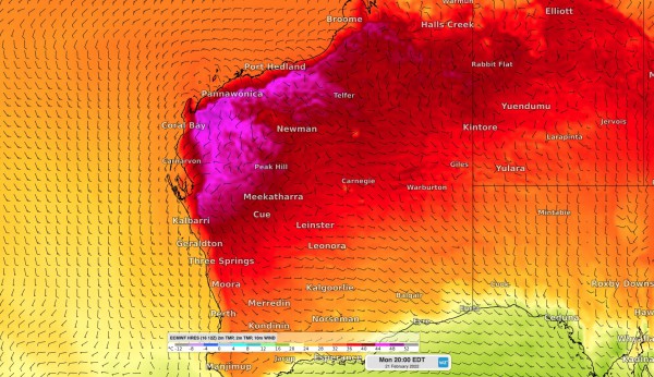
The heat is set to peak on Sunday and Monday with temperatures tipped to hit the mid-to-high 40’s. The map below shows the hot airmass being driven over northwestern WA on Sunday and Monday. 

MicrosoftTeams-image (239)

MicrosoftTeams-image (238)

 Images: Forecast surface air temperature and wind speed/direction on Sunday (top) and Monday (bottom) afternoons, according to the ECMWF model. 

This hot and dry air will combine with strong and gusty winds at times, resulting in very high to severe fire danger ratings over a number of districts in the coming days.  

A fire weather warning was issued on Thursday for the Central West and Gascoyne districts, while on Friday the severe fire danger will spread to the East Pilbara, Lower West Coast, North Interior and Central West districts. 

Fire danger is likely to remain elevated through the weekend and into the start of next week as well as the hot air mass lingers over the state’s west and north. 

This heatwave will also cause Perth to reach the mid-to-high 30’s for the rest of this week and early next week, peaking on Friday at around 38ºC.  For more information on Weatherzone’s extreme heat and fire danger forecasting, please contact us at apac.sales@dtn.com.

Latest news

Satisfy your weather obsession with these news headlines from around the nation, and the world.

Perth sets rainfall streak not seen in 18 years as water storage levels fall

For four months in a row, Perth has exceeded its average monthly rainfall – the first time this has happened in the traditionally wet winter and spring period since 2007. Perth reached its September average of 79.3mm during light showers on Tuesday and Wednesday. Another 13.2mm of rain then fell in the 24 hours to […]

DTN remote sensing captures rain and thunderstorms lashing Solomon Islands

Aviation, mining and shipping industries in the Solomon Islands and other South Pacific nations are often unable to use traditional radar to warn of incoming storms that disrupt operations and put workers in harm’s way. DTN APAC offers a suite of remote sensing weather solutions that give businesses and industries in remote areas around the […]

Negative Indian Ocean Dipole officially underway – here’s what it means for Australian businesses and industries

A negative Indian Ocean Dipole (IOD) event is now underway, increasing the likelihood of above average rain over large parts of Australia in the coming months. What is the Indian Ocean Dipole (IOD)? The IOD is an index used to monitor sea surface temperatures across the tropical Indian Ocean. It’s an important index for the […]

La Niña more likely this year after BoM switches to new index – what does this mean for Australian businesses?

The likelihood of La Niña occurring in 2025 has increased due to a change in the way the Bureau of Meteorology calculates sea surface temperature anomalies in the tropical Pacific Ocean. What is La Niña? La Niña refers to a distinct pattern of sea surface temperatures across the tropical Pacific Ocean. When La Niña is […]