A tropical low located to the south of the Solomon Islands has the potential to intensify into a tropical cyclone this weekend.
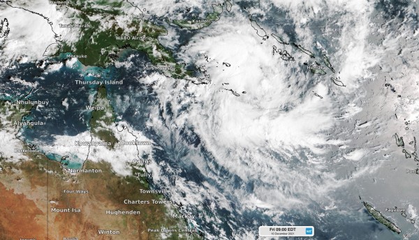
The satellite image below shows the low in at 9am AEDT on Friday. The large mass of cloud in the image shows that there is a lot of convection occurring near the developing low, which is common in the early stages of tropical cyclone development.

There is a good chance that the low will develop into a tropical cyclone to develop in Australia’s East Region this weekend. This region has been highlighted in blue in the map below.

If it does become a tropical cyclone inside Australia’s area of responsibility, it will be our second cyclone so far this season and will be named Ruby.
Fortunately, the system is expected to stay well away from the Australian mainland and should move south and then east, out of the East Region, over the weekend and early next week.
Early start to the 2021/22 cyclone season
Cyclone Paddy was the first tropical cyclone to develop in the Australian region this season, forming to the west of Christmas Island on November 18. This is several weeks earlier than usual for the first cyclone of the season, although this early start was anticipated due to the influence of La Niña.
It is also rare for tropical cyclones to form this early in the season in the East Region, with most of the early-season cyclones usually forming to the north or northwest of Australia. During the last 40 years, the East Region has only seen four tropical cyclones this early in the season, while the West Region has had 35 cyclones forming this early.
The last cyclone in the East Region to form this early in the season was tropical cyclone Owen, which formed in earl December in 2018.
Why do cyclones form later in the East region?
There are a few reasons why cyclones develop later in the East Region compared to the other regions. These include the Madden Julian Oscillation (MJO), the Intertropical Convergence Zone (ITCZ) and thunderstorms climatology.
Firstly, the Madden Julian Oscillation (MJO), which is a pulse of cloud and rainfall that moves eastwards around the equator every 30-60 days, can enhance cyclone activity when it is near the Australian region.
As the MJO moves from west to east, the West Region usually has the first chance for cyclone development before the MJO moves into the East Region.
Secondly, the Intertropical Convergence Zone (ITCZ), which is a band of low pressure, rain and thunderstorms in the tropics, is generally stronger near Western Australia this early in the season. Strong, hot winds from India and Asia move this zone of tropical activity down towards the West Region earlier in the season.
Lastly, over Indonesia, tropical lows and clusters of thunderstorms are a regular occurrence at this time of year. These cluster of storms in the West Region can help in the initial stages of tropical cyclone development.
Why is there a high chance a cyclone will develop this weekend?
The MJO, or the pulse of cloud and rainfall that increases the risk of cyclone development, is currently located in the Western Pacific Ocean. The MJO has also gained strength as it moved into the East Region, increasing the likelihood of this low developing into a cyclone over the weekend.
The MJO’s location is also likely to increase cloud and rainfall across the western Pacific and northern Australia in the next week or two.
Western equatorial Pacific Ocean waters are also much warmer than normal for this time of year, thanks to La Niña.
Tropical cyclones only form when the ocean’s surface temperature is above 26.5 degrees and when it comes to tropical cyclone strength, it is a case of the warmer the better.
Weatherzone provide tropical cyclone forecasts, risk analysis and consultancy to our clients, for more information, please contact us at apac.sales@dtn.com.


