Ex-tropical cyclone Anika is crossing the Pilbara coast below tropical cyclone strength, despite spending time over water during the last 24 hours.
After moving off the Dampier Peninsula on Tuesday, Anika was expected to intensify on Wednesday and cross the east Pilbara or west Kimberley coast on Wednesday night or Thursday morning as a category two tropical cyclone.
However, the system has remained too close to the coast in the last 24 hours and has moved faster than anticipated, preventing further development.
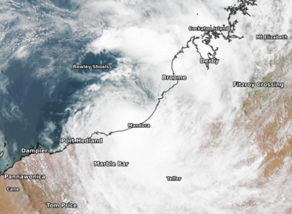
The satellite image below shows Ex-tropical cyclone Anika sitting just offshore near Mandora, off the northwest shelf of WA, on Wednesday afternoon.

Image: Visible satellite image at 15:10pm WST on Wednesday, March 2, showing a mass of cloud encircling Ex-tropical cyclone Anika
Anika is currently moving southwest near the coast off Eighty Mile Beach and will now struggle to develop into a cyclone unless the system moves west, allowing it to remain over water for longer.
At this stage, Anika is forecast to cross the coast east of Wallal later this afternoon or tonight as a low-pressure system.
Despite likely making landfall below cyclone strength, gales may still reach up to 100km/h between Bidyadanga and Wallal Downs on Wednesday as the system approaches and crosses the coast. If the system tracks further west, these gales may extend towards Pardoo.
Heavy rainfall has already begun along the Kimberley and Pilbara coast, with Bidyadanga recording 116mm in the 24-hours to 9am. Rain will become heavier along the coast and adjacent inland between Bidyadanga and Wallal Downs tonight and on Thursday, as the system crosses the coast.
The image below shows one model’s 24hour forecast rainfall to 2pm WST on Thursday, March 3.

Image Access-G 24 hour forecast rainfall to 2pm WST on Thursday, March 3.
After making landfall, ex-Tropical Cyclone Anika is likely to move inland over northern WA and gradually weaken, which will allow wind and rain to ease near the coast from late Thursday. However, heavy rain and potentially damaging winds should spread inland over the East Pilbara and Interior districts of WA on Thursday, likely affecting Marble Bar and Telfer.
Rain and wind should ease later Friday in the East Pilbara and Interior districts as the system weakens further. For more information, please contact us at apac.sales@dtn.com.


