There are signs that the tropics will reawaken over the coming week, with potential for two tropical low pressure systems or cyclones forming in the Australian region.
Despite La Niña, Australia has been having a relatively quiet tropical cyclone season so far. Since the start of November, there have only been four cyclones named inside Australia’s area of responsibility. This is well below the seasonal average of 11-12. The last tropical cyclone named in the Australian region was Tiffany, which first formed on January 8, over a month ago.
This run without any new tropical cyclones could be about to end, with the monsoon trough becoming active over northern Australia and the Madden-Julian Oscillation moving into the Maritime Continent (north of Australia). Both of these features can cause an increase in tropical cyclone activity.
A number of forecast models suggest that two tropical lows may develop near northern Australia later this week, one to the north of WA and the other somewhere around the Gulf of Carpentaria or northern Coral Sea.
At this stage it is too early to know exactly where, when and how much these low pressure systems will develop. However, there is enough model agreement to suggest that the two low pressure may move into environments that are favourable for tropical cyclone development near Australia, most likely towards the end of this week or early next week.
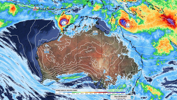
The map below shows one models forecast for Sunday, February 27, with a low pressure system or cyclone in the Coral Sea and off the northwest shelf of Australia.

Image: ECMWF Mean Sea Level Pressure (MSLP) and rainfall forecast at 11pm EDT Sunday, February 27, showing low pressure systems or cyclones off the northwest shelf and the Coral Sea.
With a large degree of uncertainty at play, communities and industries based in northern WA, the NT’s Top end and anywhere from northern to southeast QLD should closely monitor the latest forecasts and tropical cyclone advisories during the next fortnight.
Tropical cyclone activity typically peaks in the Australian region during February and March due to an abundance of warm water around the continent. Sea surface temperatures are currently even warmer than usual around most of northern Australia at the moment, which will assist in the development of any low pressure systems that form.

Image: Sea surface temperature anomaly (deg C) on Sunday, February 20, showing warm water surrounding northern Australia. Source: Bureau of Meteorology (BOM).
Weatherzone will be closely monitoring the situation and providing more updates in the coming days. For more information on Weatherzone’s tropical cyclone risk analysis and forecasting, please contact us at apac.sales@dtn.com.


