Prosper in a dynamic world
Search

Heavy showers and severe storms in NSW today

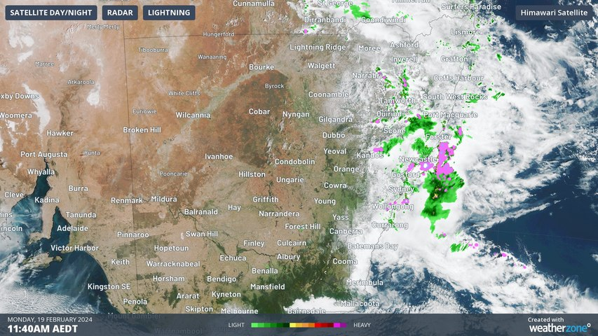
Near-stationary thunderstorms caused a burst of heavy rain near Newcastle on Monday morning, with more downpours expected in other areas of NSW and southern Qld later in the afternoon and overnight.

Moisture-laden air interacting with a low pressure trough will produce showers and thunderstorms over a broad area of eastern and northern NSW, and soutern Qld during the next 12 to 24 hours.

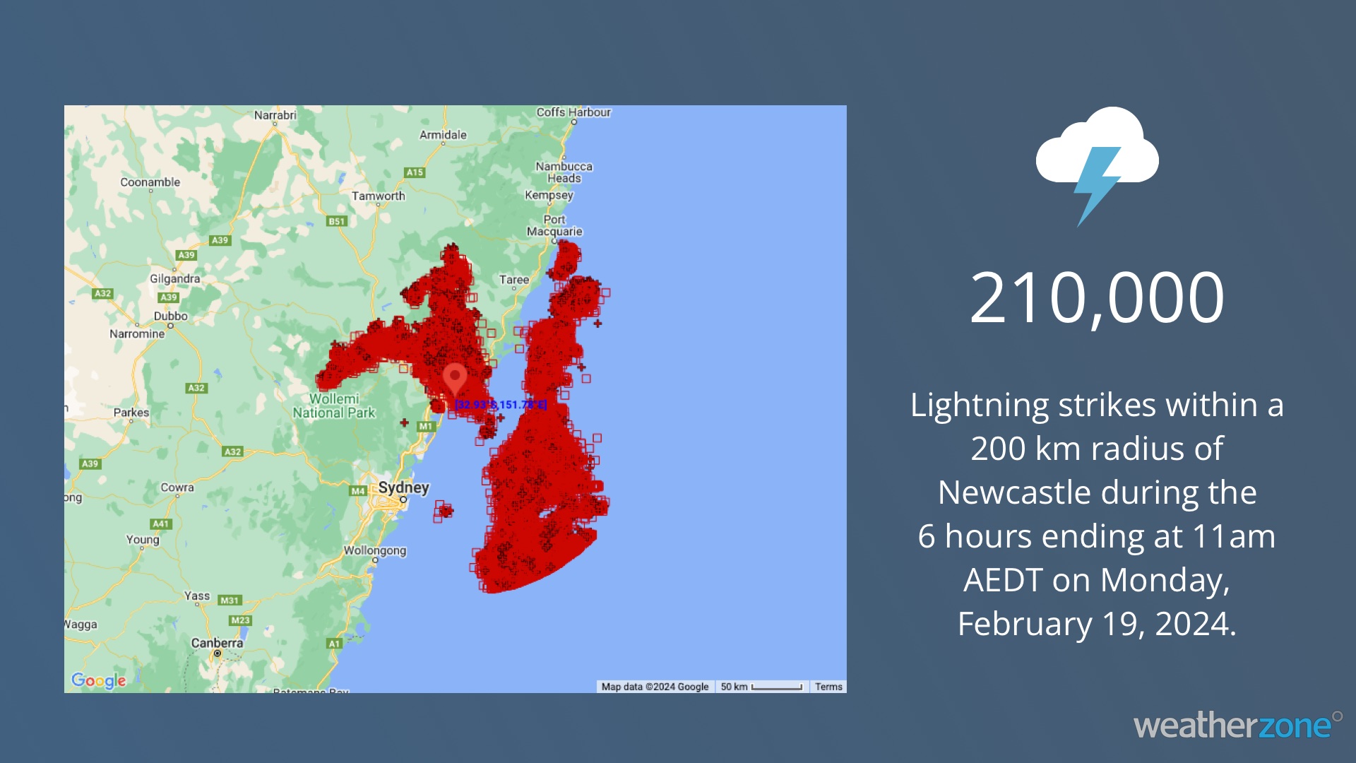
On Monday morning, several slow-moving thunderstorms develop in the Newcastle region, causing areas of heavy rain and prolific lightning.

Total Lightning Network detected around 210,000 lightning strikes within a 200 km radius of Newcastle between 5am and 11am AEDT on Monday.

Slow-moving storms increase the risk of flash flooding by causing heavy rain over a single location for a prolonged period. This risk prompted the Bureau of Meteorology to issue a severe weather warning for heavy rainfall and flash flooding in parts of the Hunter and Central Tablelands Forecast Districts.

A rain gauge at Hunter Springs, to the west of the Barrington Tops, received 23 mm of rain within one hour on Monday morning. Further south, Williamtown picked up 12 mm in an hour from a separate storm.

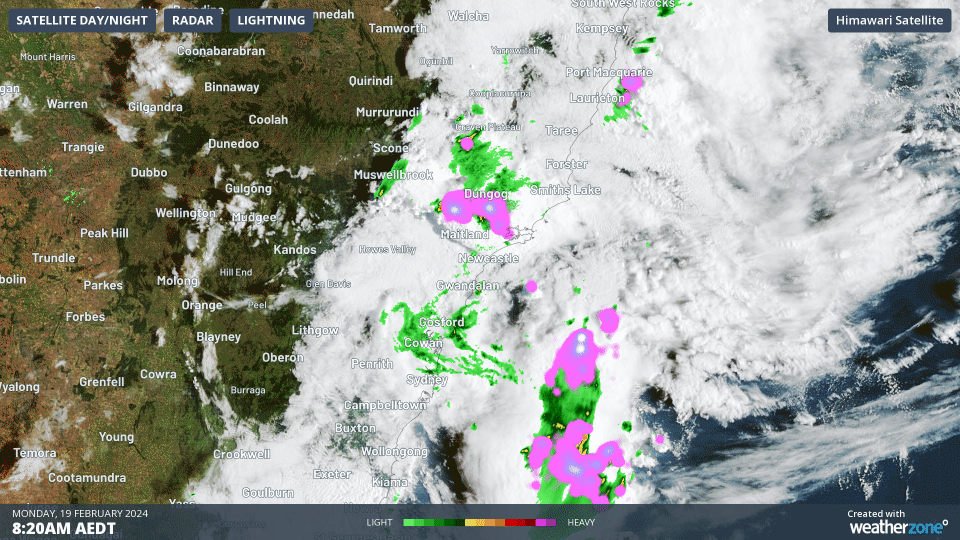
Video: Composite satellite, radar and lightning showing thunderstorms over eastern NSW on Monday morning.

Looking ahead, showers and thunderstorms will spread further across eastern and northern NSW and southern Qld on Monday afternoon and evening. Some of these storms could produce heavy rain and flash flooding, although the storms and their impacts will be hit and miss.

Be sure to check the latest severe thunderstorm warnings for the most up-to-date information on the storms and the risk of flooding as the storms progress further north.

Stormtracker is a severe weather solution that can assist you in observing, real-time, any storm or event that has the potential to impact your business. For more information, please contact us at apac.sales@dtn.com. 

Latest news

Satisfy your weather obsession with these news headlines from around the nation, and the world.

Giant hail and intense thunderstorms leaves 161,000 customers without power across southeast Queensland

Over 75,000 customers across southeast Queensland remain without power on Tuesday, after a peak of around 161,000 following the relatively brief, but intense severe thunderstorms complex that crossed the region on Monday afternoon. Damage to power utility networks and rescue efforts for residents was worse than those inflicted by Cyclone Alfred in March for some […]

How a tropical cyclone near Darwin causes energy demand to soar in NSW and Queensland

The downstream influence of Severe Tropical Cyclone Fina caused intense inland heat to build and be drawn into eastern Australia, causing energy demand to soar in NSW and Queensland. Severe Tropical Cyclone Fina crossed the northeast Kimberley coast in WA late on Monday, November 24, 2025, but downstream influences from the system will be felt […]

Tropical Cyclone Fina to pass near Darwin this weekend – possible disruptions to key industries

Tropical Cyclone Fina has turned towards the Northern Territory coast and is expected to make landfall over the Top End on Friday, November 21, 2025. The system could then regain strength over the warm Van Diemen Gulf, before passing close to Darwin on the weekend. The last tropical cyclone to directly impact Darwin was Tropical […]

High tropical cyclone risk near northern Australia this week

A tropical low currently developing over the Timor Sea has a high chance of becoming a tropical cyclone later this week, with a possibility of landfall somewhere in the Northern Territory or Western Australia. Key industries could be impacted including Ports, Mining, Transport, and Agriculture. The satellite images below show cloud circulating around the developing […]