Prosper in a dynamic world
Search

Which Aussie city had the hottest Christmas Day?

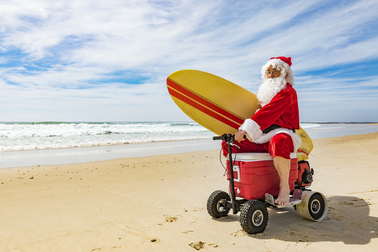
Christmas Day weather can be a bit of a mixed bag in Australia, fluctuating from extreme heat to winter-like days or heavy rain to blue skies.  

The contrasting weather over the years has had Australians either reaching for a jacket or the air con switch or sometimes ducking for cover as a storm rolls in. 

We have crunched the numbers to find out how hot, cold and wet each Australian capital city has been on Christmas Day in the past. 

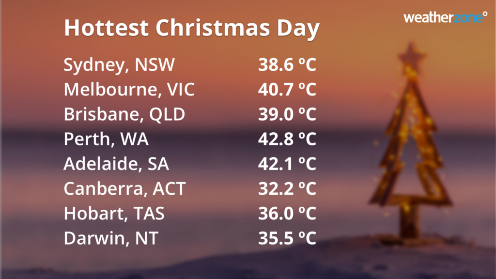
The hottest Christmas day recorded across the capital cities in Australia was Perth, recording 42.8°C in 2021. Adelaide came a close second, recording 42.1C back in 1888. 

The image below shows the hottest maximum temperatures on Christmas Day recorded for each Australian capital city.  

Which Aussie city had the hottest Christmas Day?

 While Christmas occurs in the Australian summer and it’s usually a warm time of year, cool temperatures and even snow have impacted the country’s southern states over the years. 

The coolest Christmas day recorded across the Australian capital cities was 12.6°C in Hobart in 1911. The image below shows the lowest daytime temperatures recorded in each capital city on Christmas day.  

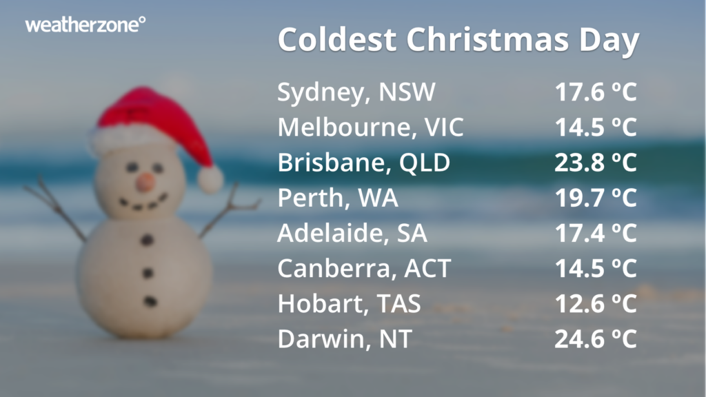
  As it turns out, Christmas is always warm in Darwin, with the maximum temperature failing to fall below 24.6°C on Christmas Day since records began.  

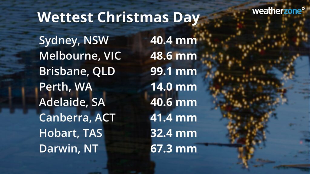
The wettest Christmas days have occurred in the northernmost cities of Brisbane and Darwin. The image below shows the highest rainfall that fell in each capital city in the 24 hours leading up to 9am on Boxing Day.  

Whatever the weather is for you today, we hope you have a great day and a happy new year. 

Latest news

Satisfy your weather obsession with these news headlines from around the nation, and the world.

Powerful swells sweeping across Australia, Indonesia and the Pacific impacting port and maritime operations

Huge Southern Ocean swells generated by a series of cold fronts are bearing down on three of Australia’s coastlines, and parts of Indonesia and the Pacific. Vigorous cold fronts to the south and southwest of Australia have been generating gale to storm force winds over the past few days. Gale force winds can be estimated […]

Daytime chill across NSW with cloudband impacting solar production

A broad cloudband of tropical origins is stretching across much of NSW, bringing chilly daytime temperatures and low solar energy generation. The satellite imagery below shows a broad area of cloud extending across much of NSW on Tuesday. The temperature observation overlaid shows the mercury struggling to exceed the low-teens, with alpine and tableland areas […]

Tropical Storm Nari threatens Tokyo and northern Japan shipping and transportation industries

Tropical Storm Nari, the fifth tropical cyclone of the western Pacific typhoon season formed over the weekend, and is tracking close to Tokyo and northern Japan on Monday. As seen in the satellite imagery below, Nari tracked north rapidly on Monday morning, coming within 250 kilometres of Tokyo around midday. Video: Satellite imagery of Tropical […]

Australia’s warmest financial year on record

The data is in, and Australia just registered its warmest financial year on record with a mean temperature more than 1.5°C above the long-term average. It may seem odd to measure the climate of Australia’s fiscal year, but there are benefits to compiling climate summaries for the 12-month period from July to June. Firstly, the […]