Prosper in a dynamic world
Search

Two ‘northwest cloudbands’ to soak Australia this week

Rain will fall over large areas of every Australian state and territory this week as two northwest cloudbands sweep across the country.

Northwest cloudbands are large bands of cloud that spread across Australia from the northwest towards the southeast. They are caused by moisture-laden air from the tropical Indian Ocean and typically produce widespread rain over Australia between autumn and spring.

This week, two northwest cloudbands will pass over Australia as streams of Indian Ocean moisture move south and interact with a series of cut-off upper-level lows passing over the nation’s southern states.

The animation below shows precipitable water in the atmosphere during the next seven days, revealing the two pulses of airborne moisture spreading across Australia.

Video: Precipitable water and 500 hPa height during the coming week, according to the ECMWF-HRES model.

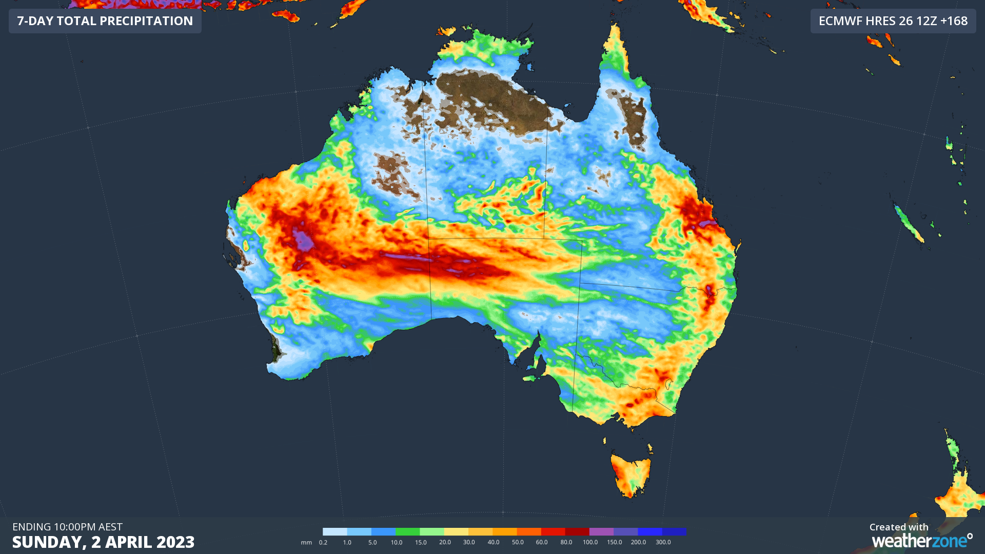
Rain will fall over much of every state and territory this week, with some places also likely to see thunderstorms. Pockets of heavy rain will produce areas of flooding, both with and independent of thunderstorms.

Two ‘northwest cloudbands’ to soak Australia this week

Image: Forecast accumulated rain this week, according to the ECMWF-HRES model.

You will find regular updates on this week’s wet and stormy weather on the Weatherzone news page, and you can also check the latest severe weather and thunderstorm warnings here.

Latest news

Satisfy your weather obsession with these news headlines from around the nation, and the world.

How does DTN help businesses monitor bushfire induced pyrocumulonimbus thunderstorms that ignite more fires?

Intense heat from bushfires during elevated fire danger days can trigger fire-induced pyrocumulonimbus thunderstorms that ignite additional fires. In early January 2026, an extreme heatwave sweeping over southeastern Australia brought catastrophic fire danger to Victoria. Intensely hot bush and grass fires spread erratically and quickly in hot, dry and gusty winds, with pyrocumulonimbus generating lightning, […]

Active seas to the north and east of Australia disrupting port and maritime operations

Seas to the north and east of Australia are experiencing periods of increased activity this week, leading to disruptions to port, maritime and offshore operations. Intense and hazardous Tasman Sea Ocean conditions across NSW’s South Coast rapidly deteriorated last Friday as a deep feed of easterly winds whipped up large and dangerous seas. The Batemans […]

Transport, emergency and energy industries flooded across Greater Sydney with weekend deluges

Transport, emergency, energy and port industries in eastern NSW and Sydney were impacted by significant flash flooding with intense and heavy rainfall this weekend. Rainfall rates between 80 and 140mm in one to three hours were registered across parts of Sydney’s Northern Beaches and Central Coast on Saturday afternoon and evening. In some areas, these […]

DTN Dangerous Thunderstorm Alerts in action with severe thunderstorms disrupting Perth industries

Severe thunderstorms impacted southwest WA and the Perth region on Sunday, December 14, 2025, triggering Dangerous Thunderstorm Alerts (DTA) by DTN for industries and businesses in the region. DTN operates Dangerous Thunderstorm Alerts (DTA) which alert businesses and industries to thunderstorms based on intensity and movement. These alerts provide advanced notice of thunderstorms moving into […]