Heatwaves in the National Electricity Market (NEM) are often generated by slow moving high pressure systems, which drag warm and dry air from the interior of the country into the NEM. Tropical cyclones off the northwest shelf of Australia is something to watch out for when forecasting the risk of heatwaves. Tropical cyclones off the northwest shelf of Australia generate deep convection (warm rising air generates large tall clouds and divergent flow away from the cyclone at high levels in the atmosphere). The convection and or the divergent flow can reinforce upper level high pressure systems, which may produce stubborn slow moving high pressure systems at the surface.
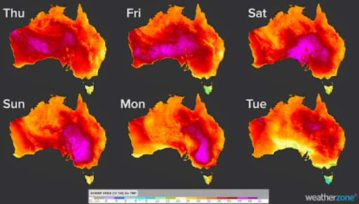
A tropical low pressure system located in the Indian Ocean is forecast to develop into a cyclone tomorrow (22/01/21), making landfall on the Pilbara coast during Saturday (23/01/21). Not coincidentally, a severe heatwave is forecast for the NEM from tomorrow (22/01/21) to Tuesday next week (26/01/21). The heatwave will begin from tomorrow in SA, extending throughout the NEM over the weekend. The heat is set to peak during Sunday and Monday (24th and 25th Jan) for the NEM, with temperatures reaching the low to mid 40’s in places

During Sunday the 24th, Adelaide is forecast to observe it’s hottest day with temperatures above 40C forecast. While seabreezes at Melbourne, Sydney Observatory Hill and Brisbane will suppress the temperature to the low to mid 30’s, although humidity will be high. Bankstown in Sydney’s west is forecast to reach the mid to high 30’s before the seabreeze extends throughout the Sydney Basin.
Adelaide’s overnight temperatures on Saturday and Sunday night are not forecast to drop below 25 degrees, which will add to the discomfort.
Monday the 25th is the hottest day for Victoria, with Melbourne forecast to reach 40 degrees, due to strong and hot northwesterly winds preventing a seabreeze. A southerly change is forecast to whip through Victoria on Monday, reaching Melbourne during the late afternoon to early evening. This will provide some cool relief to Melbournians after a hot few days. Bankstown is also forecast to reach the high 30’s during Monday, while Observatory Hill, Archerfield and Brisbane’s temperatures are capped at the low 30’s due to a strong seabreeze.
For temperature profiles for the capitals of the NEM, other information and statistics on the heatwave please contact us at Weatherzone by emailing apac.sales@dtn.com.


