Prosper in a dynamic world
Search

Sydney’s wettest July on record


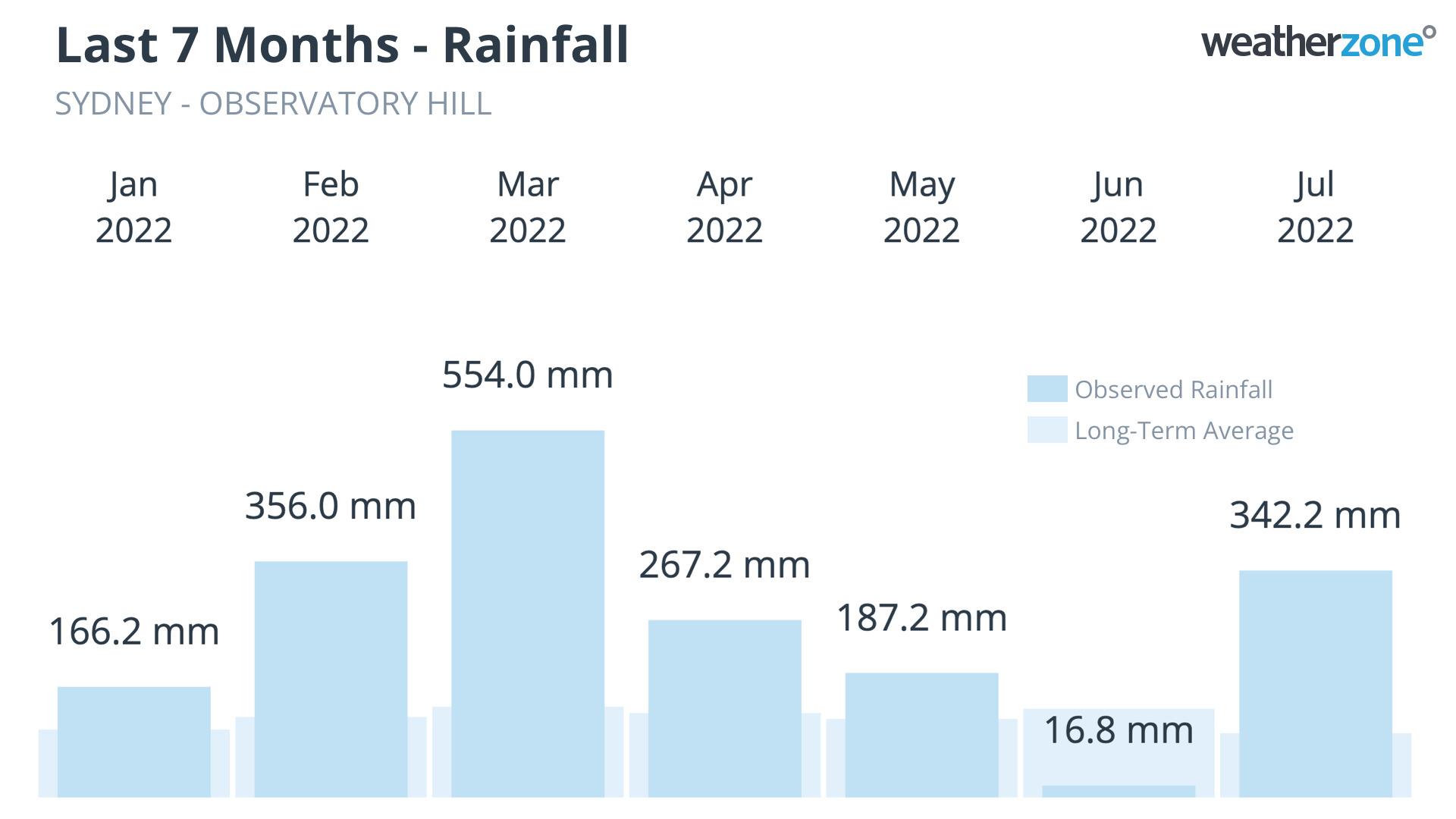
Sydney is already having its wettest July on record, despite only being halfway through the month.

As of 9am on Thursday, July 14, Sydney’s Observatory Hill weather station had received 342.2 mm of rain since the beginning of the month. This is about 3.5 times its long-term July monthly average, and makes this already Sydney’s wettest July in records dating back to 1858.

Prior to 2022, Sydney’s highest July total was 336.1 mm in 1950. Impressively, it only took 14 days to break that record in 2022.

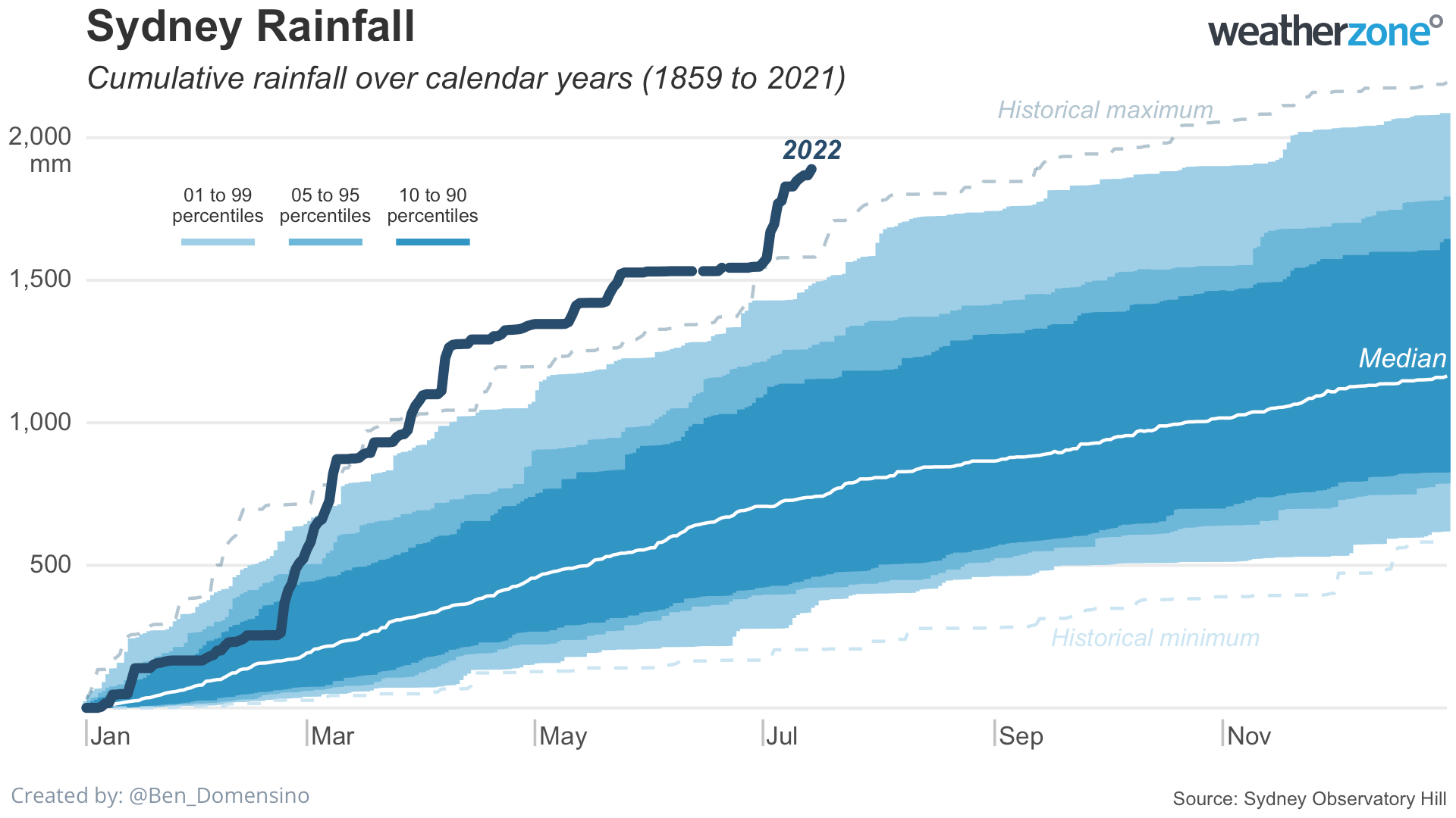
This month’s record-breaking rainfall continues an exceptionally wet year for Sydney. The city’s Observatory Hill weather station registered 1547.4 mm of rain during the first six months of 2022, which was its wettest January to June period in 164 years of records.

With July’s rainfall now added to the mix, Sydney’s running annual total had hit a whopping 1889.6 mm as of 9am on Thursday, July 14. This is easily Sydney’s wettest year-to-date on record, beating 1581.1 mm to the same date in 1891, by more than 300 mm.

Latest news

Satisfy your weather obsession with these news headlines from around the nation, and the world.

Perth sets rainfall streak not seen in 18 years as water storage levels fall

For four months in a row, Perth has exceeded its average monthly rainfall – the first time this has happened in the traditionally wet winter and spring period since 2007. Perth reached its September average of 79.3mm during light showers on Tuesday and Wednesday. Another 13.2mm of rain then fell in the 24 hours to […]

DTN remote sensing captures rain and thunderstorms lashing Solomon Islands

Aviation, mining and shipping industries in the Solomon Islands and other South Pacific nations are often unable to use traditional radar to warn of incoming storms that disrupt operations and put workers in harm’s way. DTN APAC offers a suite of remote sensing weather solutions that give businesses and industries in remote areas around the […]

Negative Indian Ocean Dipole officially underway – here’s what it means for Australian businesses and industries

A negative Indian Ocean Dipole (IOD) event is now underway, increasing the likelihood of above average rain over large parts of Australia in the coming months. What is the Indian Ocean Dipole (IOD)? The IOD is an index used to monitor sea surface temperatures across the tropical Indian Ocean. It’s an important index for the […]

La Niña more likely this year after BoM switches to new index – what does this mean for Australian businesses?

The likelihood of La Niña occurring in 2025 has increased due to a change in the way the Bureau of Meteorology calculates sea surface temperature anomalies in the tropical Pacific Ocean. What is La Niña? La Niña refers to a distinct pattern of sea surface temperatures across the tropical Pacific Ocean. When La Niña is […]