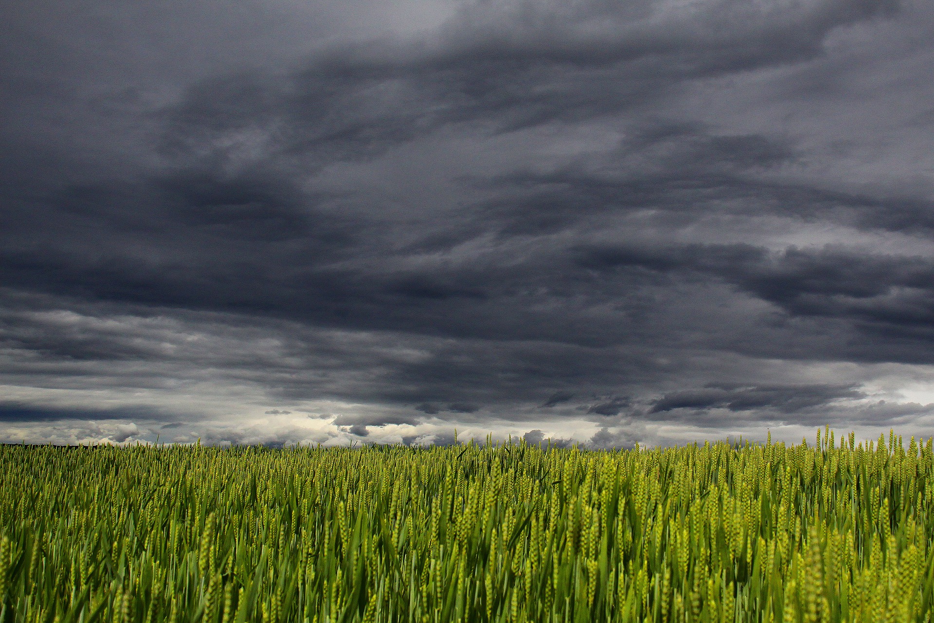
Tomorrow marks the first day of spring, a season which typically brings a mix of dynamic weather across Australia. But what will spring be like this year across the country?
When predicting how this spring will unfold, we look at the broad-scale climate drivers that are likely to influence Australia’s weather during the next 3 months.
This spring, there are several strong climate drivers at play which will influence the weather in the coming months.
Indian Ocean Dipole (IOD)
The Indian Ocean Dipole (IOD) is defined by the gradient in sea surface temperatures between the eastern and western tropical Indian Ocean. While the IOD can have a big influence on Australia’s weather in winter and spring, it usually breaks down by the start of summer.
A negative Indian Ocean Dipole (IOD) was officially declared in early August after sea surface temperatures in the Indian Ocean exceeded the negative IOD threshold for eight weeks.
A negative Indian Ocean Dipole (IOD) refers to a pattern of sea surface temperatures in the tropical Indian Ocean that causes more moisture-laden air to flow towards Australia.
These negative IOD events, which occur on average once every five years, typically enhance northwest cloudbands over Australia and produce above-average rain over large areas of country’s south and southeast during winter and spring.

This is now the 2nd consecutive year to be declared a negative IOD year, following a relatively weak event in 2021. This is the first time we have seen two consecutives negative IOD years since reliable records of the IOD began in 1960.
Unlike last year’s event, this year’s negative IOD is strong and should continue through to late spring and possibly early summer, before rapidly decaying in summer.
El Niño-Southern Oscillation (ENSO)
The El Niño–Southern Oscillation (ENSO) is the oscillation between El Niño, La Niña and neutral conditions in the Pacific Ocean. El Niño typically produces drier and warmer weather in Australia, while La Niña drives wetter and cooler years.
After two back-to-back La Niña events between September 2020 and June 2022, the Pacific Ocean has been a neutral state, albeit close to La Niña thresholds, for the last two months. However, all oceanic and atmospheric indicators used to monitor the Pacific Ocean have been trending towards La Niña levels in the past month, indicating that La Niña may be re-emerging for a third consecutive year.
International climate agencies are all giving a 60 to 80 percent chance of La Niña occuring in spring, including the Bureau of Meteorology, U.S. climate Prediction Centre (CPC) and the Japanese Meteorological Agency (JMA).
La Niña increases the likelihood of above average rain and below-average daytime temperatures over large areas of northern and eastern Australia during spring.

Based on current forecasts, this La Niña episode is expected to peak during spring and weaken in summer, most likely returning to a neutral state early next year.
Southern Annular Mode (SAM)
The Southern Annular Mode (SAM) is an index that measures the north-south displacement of the westerly winds that flow between Australia and Antarctica.
When the SAM is in a negative phase, westerly winds and cold fronts are located further north than usual. This typically causes more cold outbreaks along with increased wind and rainfall for southern Australia. However, negative SAM can also cause drier-than-usual weather in eastern Australia during spring.
On the other hand, a positive SAM usually causes reduced wind and rainfall in southern Australia during spring. In eastern Australia, rainfall is typically above-average when SAM is positive in spring and summer.

The SAM is currently strongly positive and is forecast to remain mostly positive through much of spring, which could enhance the wet and cloudy weather along the east coast and adjacent inland this spring.
Spring outlook
With three major climate drivers at play this spring, moisture-laden air will stream towards Australia from the Indian Ocean, Pacific Ocean and the Tasman and Coral Seas, likely enhancing rainfall across large areas of the country.
Rain and flooding
Above average rain is forecast across large parts of the country, with an increased chance of heavy rainfall events this spring, particularly over the eastern half of Australia.
With two La Niña seasons already in the bag and the prospect of a third La Niña a strong possibility, this is likely to have a compounding effect that may exacerbate the impacts we normally see in Australia.
So, while individual La Niña events usually cause more rain and flooding in northern and eastern Australia, any La Niña-fuelled rainfall this year will be falling onto already saturated ground and into full dams. This makes flooding a heightened risk, especially for areas that just had a wet year.
Cloud
Increased cloudiness is also likely across much of Australia, driven by enhanced onshore winds from a negative IOD event, a developing La Niña and predominantly positive SAM.
This increased cloud cover is likely to reduce solar output across much of the country, particularly across the eastern states this spring.
Thunderstorms
Thunderstorms require three key ingredients to develop:
- Sufficient moisture in the lower levels of the atmosphere.
- Instability in the atmosphere.
- A trigger to initiate the storm.
During spring, the negative IOD, the developing La Nina and positive phases of SAM should increase the amount of moisture available to fuel storms across much of the country.
However, positive SAM and La Niña can also reduce the instability and triggers required for storm development, particularly in southern and eastern Australia.
These influences are likely to counteract each other this spring, which should result in normal thunderstorm activity in southern and eastern Australia and normal to above normal thunderstorm activity across northern Australia.
Severe storms are still likely to produce large hail, damaging wind and heavy rain in the coming months.
It’s also worth noting that if a fully-fledged La Niña event doesn’t come to fruition, storms will likely be more frequent and intense over Australia’s eastern states. This is because neutral ENSO conditions provide the most favorable setup for thunderstorm activity in Australia.
Northern Wet Season
The warm oceans around Australia are conducive to high humidity air and above average rainfall during spring across northern Australia, particularly for the NT and QLD.
An early monsoon onset is forecast for Darwin in the 2021-22 wet season, due to the negative IOD and possible La Niña event.
Temperatures
The negative IOD and developing La Nina will both promote cooler-than-average daytime temperatures across much of Australia this spring, while nights are expected to be normal to warmer-than-notmal.-
The negative IOD and the prospect of La Niña decrease the likelihood of extremely hot days during spring. However, heatwaves are more likely in southern Australia during La Niña seasons, but they are generally not as intense as El Niño years.
Fire
A confluence of wet-phase climate drivers will reduce the risk of bushfires across large areas of Australia this spring, although grassfires could still be prolific in some parts of the country.
The map below shows The Australasian Fire and Emergency Service Authorities Council (AFAC) bushfire forecast for spring.
The blue shading on the map above shows lower-than-normal fire potential is forecast across parts of eastern NSW, Victoria and the ACT this spring.
This includes areas of bushland that are still recovering from the 2018/19 and 2019/20 bushfire season. This recovering vegetation, combined with above-average soil moisture and rainfall, is likely to suppress the potential for large and uncontrollable forest fires in the coming months.
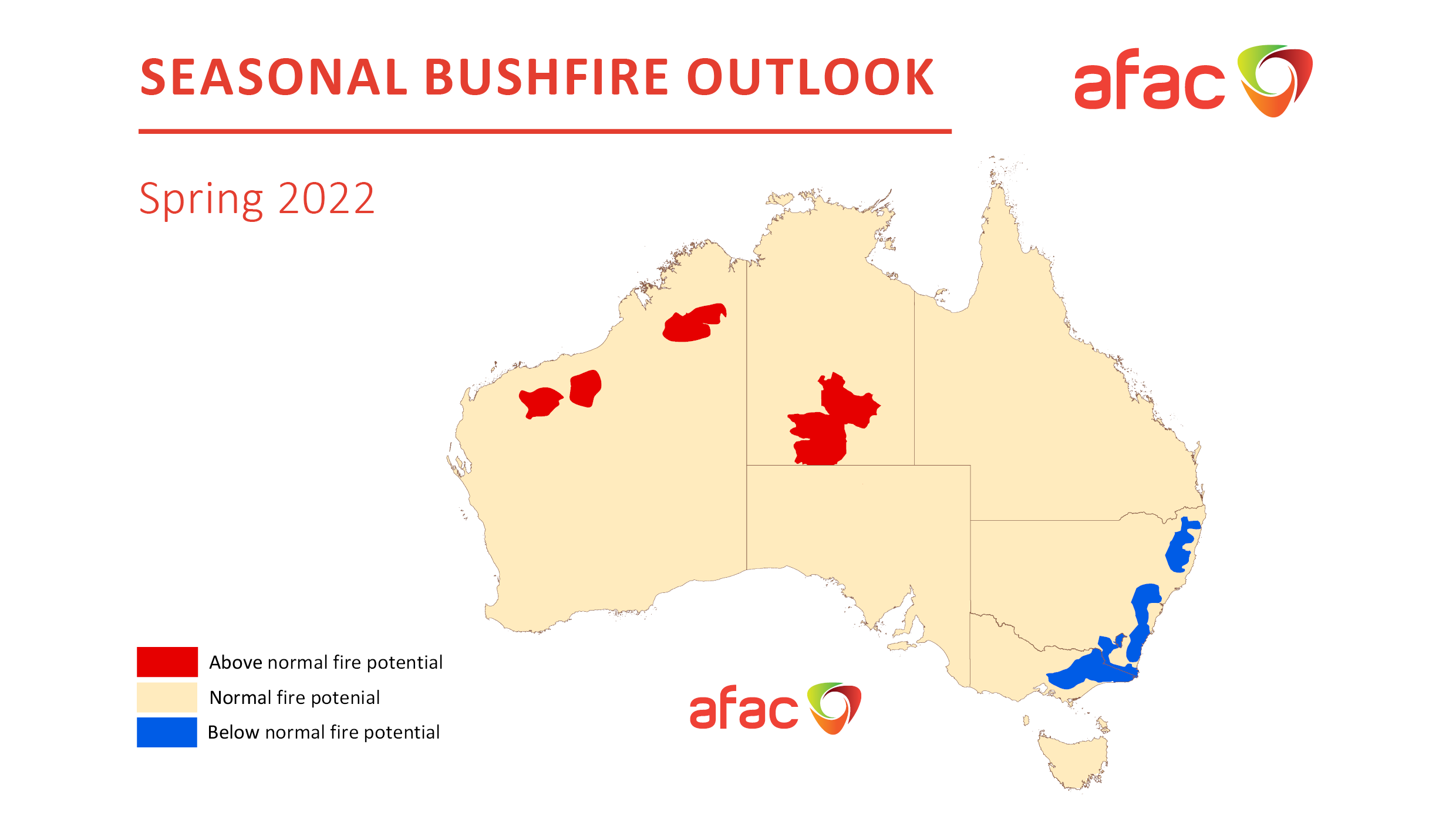
The red shading on the map above shows where fire potential is expected to be higher-than-average this spring. Rainfall in recent months has enhanced vegetation growth across these parts areas, which is now drying out and providing fuel for fires in the months ahead.
Wind
Strong wind events are likely to be less frequent in southern Australia during spring. This is due to the increased likelihood of positive SAM episodes in spring and the associated suppression of cold fronts and low pressure systems across the nation’s southern states.
While strong wind events are less frequent during La Niña and positive SAM, cold fronts and storms are still likely to move through and cause periods of increased wind this season.
Summary
In summary, daytime temperatures this spring are forecast to be below average and cooler than last spring. Extremely hot days are less likely, while prolonged heatwaves are an increased chance.
Rainfall and cloud cover should be above average for much of the country, which should help suppress bushfire activity for most of Australia, except areas that have seen prolific grass growth earlier in the year.
Thunderstorms activity is forecast to be normal this spring, with outbreaks of severe storms, heavy rain and flooding an increased risk as they move over the country.
The northern wet season should start early and bring above-average rain and thunderstorms to the tropics.
Strong wind events are less likely in southern Australia during spring. Weatherzone conducts detailed seasonal forecasts which can help with long-term planning out to six months. The seasonal forecasts are tailored to the business and can include risk of heavy rainfall and flood risk, tropical cyclones, thunderstorms, extreme heat, bushfires and much more. These forecasts can be delivered live online or face to face, allowing time for questions and increasing engagement.
For more information on our products or how we can help you with your business needs, please contact us at apac.sales@dtn.com.


