The Southern Annular Mode (SAM) – one of the main broad-scale mechanisms influencing Australia’s climate – just reached one if its strongest positive levels on record.
What is the SAM?
The SAM refers to the north-south displacement of the powerful westerly wind belt that flows around Antarctica throughout the year.
These westerly winds carry the cold fronts and low pressure systems that bring seasonal rain, snow and wind to southern Australia. So, the state of the SAM can have a noticeable influence on the weather in some parts of Australia at different times of the year.
In general, the SAM has a stronger influence on Australia’s weather between winter and summer, with less of an influence in autumn.
Each phase of the SAM typically lasts for around one to two weeks and the fluctuation between positive and negative phases can be random. The strength of each phase is also random and difficult to predict.
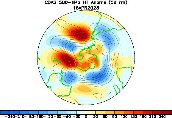
GIF: Geopotential Height of 500hPa over Antartica for the 30 days to 15th May 2023. The deep blue values over Antartica paired with the reds over 45° latitude (roughly in line with Hobart) signal a strong positive SAM. Source: NOAA
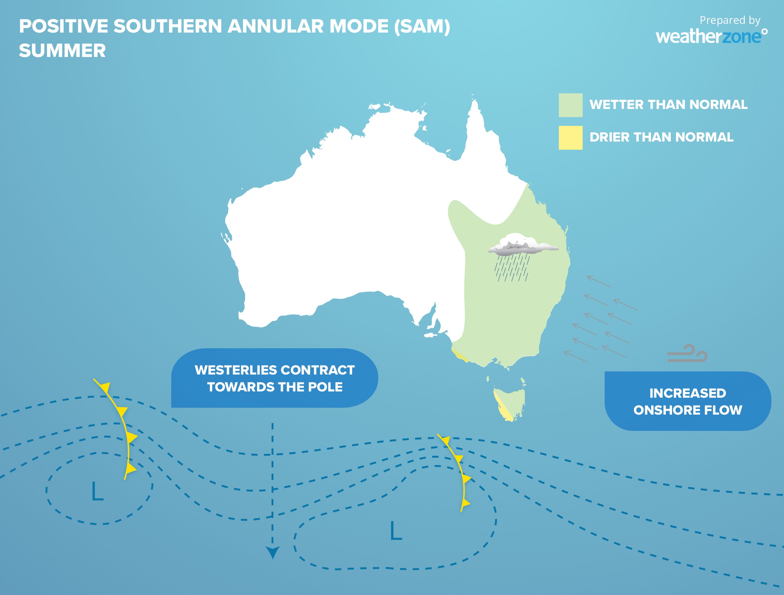
Positive SAM
When the SAM is in a positive phase, the belt of circumpolar westerly winds contracts towards Antarctica, and away from Australia.
A positive phase of the SAM during winter moves the rain and snow-bearing cold fronts further south and causes easterly winds to increase over eastern Australia. This typically reduces rainfall and snowfall over parts of southern Australia and allows more rain to fall in parts of Qld and NSW.
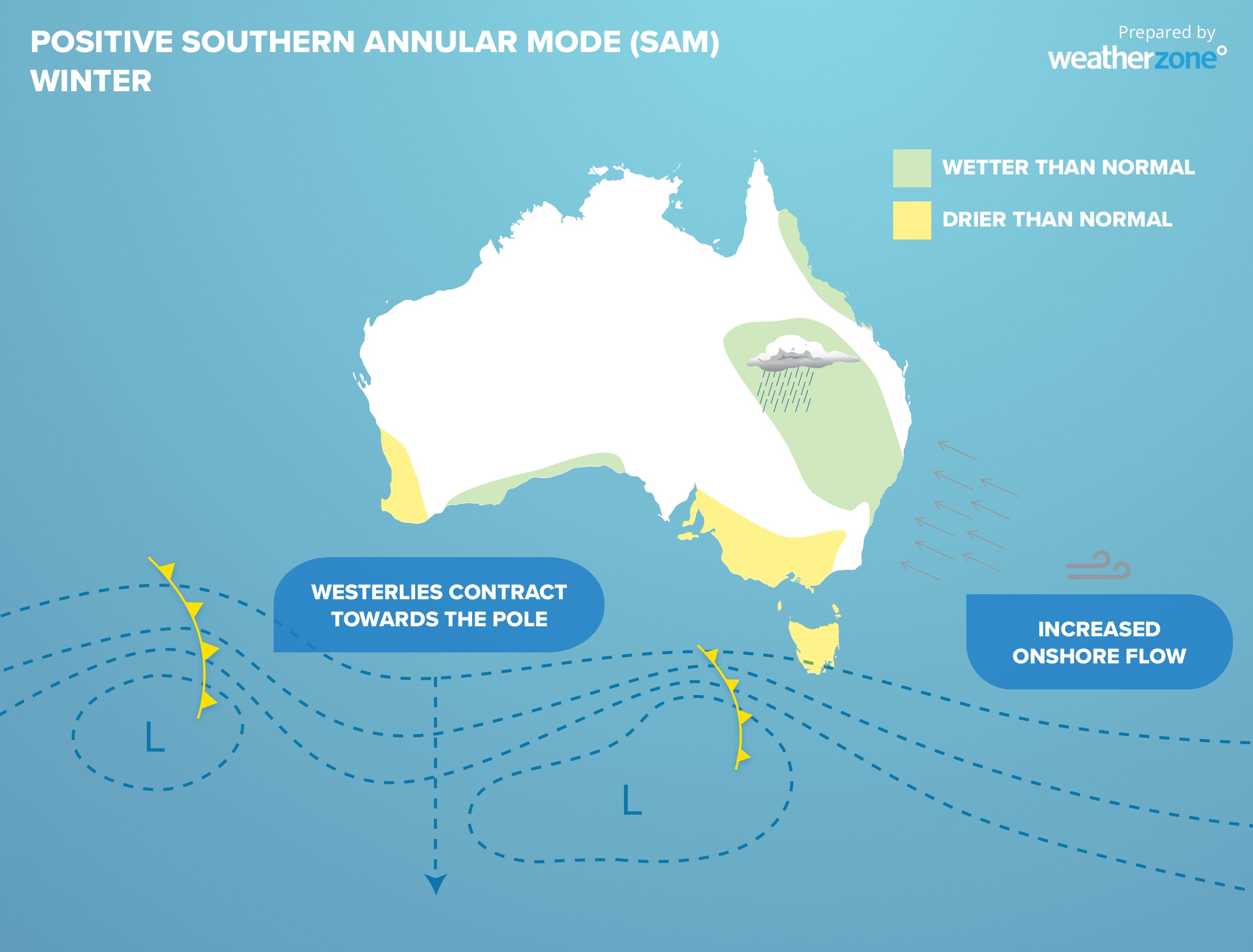
A positive phase of the SAM during summer promotes increased rainfall over much of eastern and southeastern Australia and drier than usual weather in some parts of far southern Australia.
During 2022, the SAM was positive for 11 out of the 12 months, and when combined with La Nina and a negative IOD, ensured that eastern Australia had one of its wettest years on record.
For New Zealand, southern Africa and South America, positive phases of the SAM tend to promote summer rainfalls for northern and eastern areas but hinders rain in the south. Winter rains tend to be reduced for all areas, with the exception of eastern parts of southern Africa, where they can be higher than average.
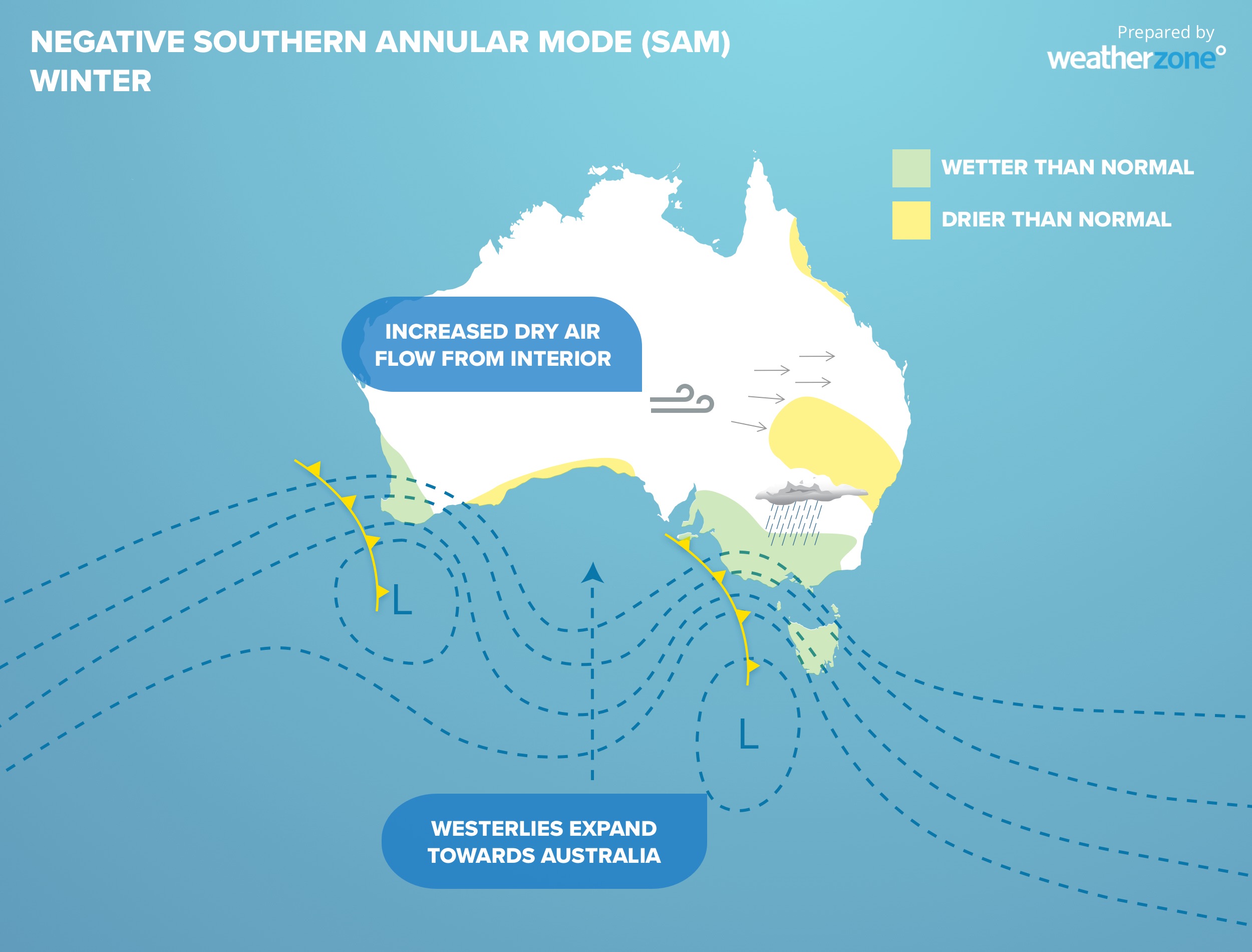
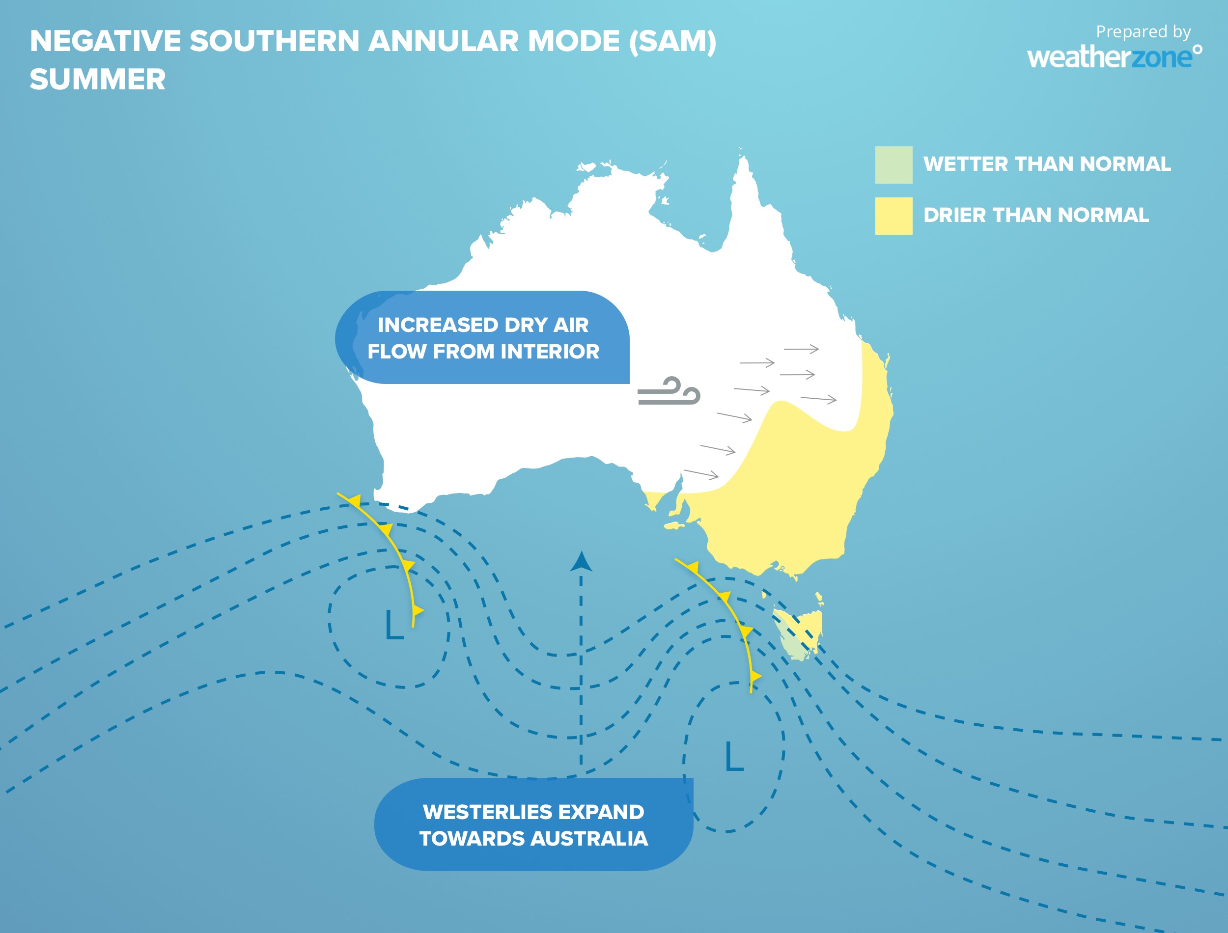
Negative SAM
Negative phases of the SAM occur when westerly winds and cold fronts shift further north, towards Australia.
In winter, negative phases of the SAM can increase rain, wind and snowfall across parts of southern Australia and reduce rain in parts of eastern Australia.
Negative SAM phases in summer also promote drier than usual weather over large areas of eastern and southeastern Australia due to an increase in westerly winds flowing over the continent. This was the primary climate driver during the infamous 2019-20 Black Summer bushfires, that promoted strong westerly winds across the Australian continent.
For New Zealand, southern Africa and South America, negative phases of the SAM tend to promote winter rains, with higher snowfalls and stronger westerly winds. During the summer months, rainfall is increased for southern parts of these regions, but it can weaken the monsoons effects further north in locations like Brazil and Mozambique.
Currently near-record positive SAM
The SAM index has reached exceptionally high values over the past week, climbing as high as +4.2 on May 13, according to data from the U.S. Climate Prediction Center. This is the ninth highest daily SAM index value in records dating back to 1970, and the highest value observed since September 2018.
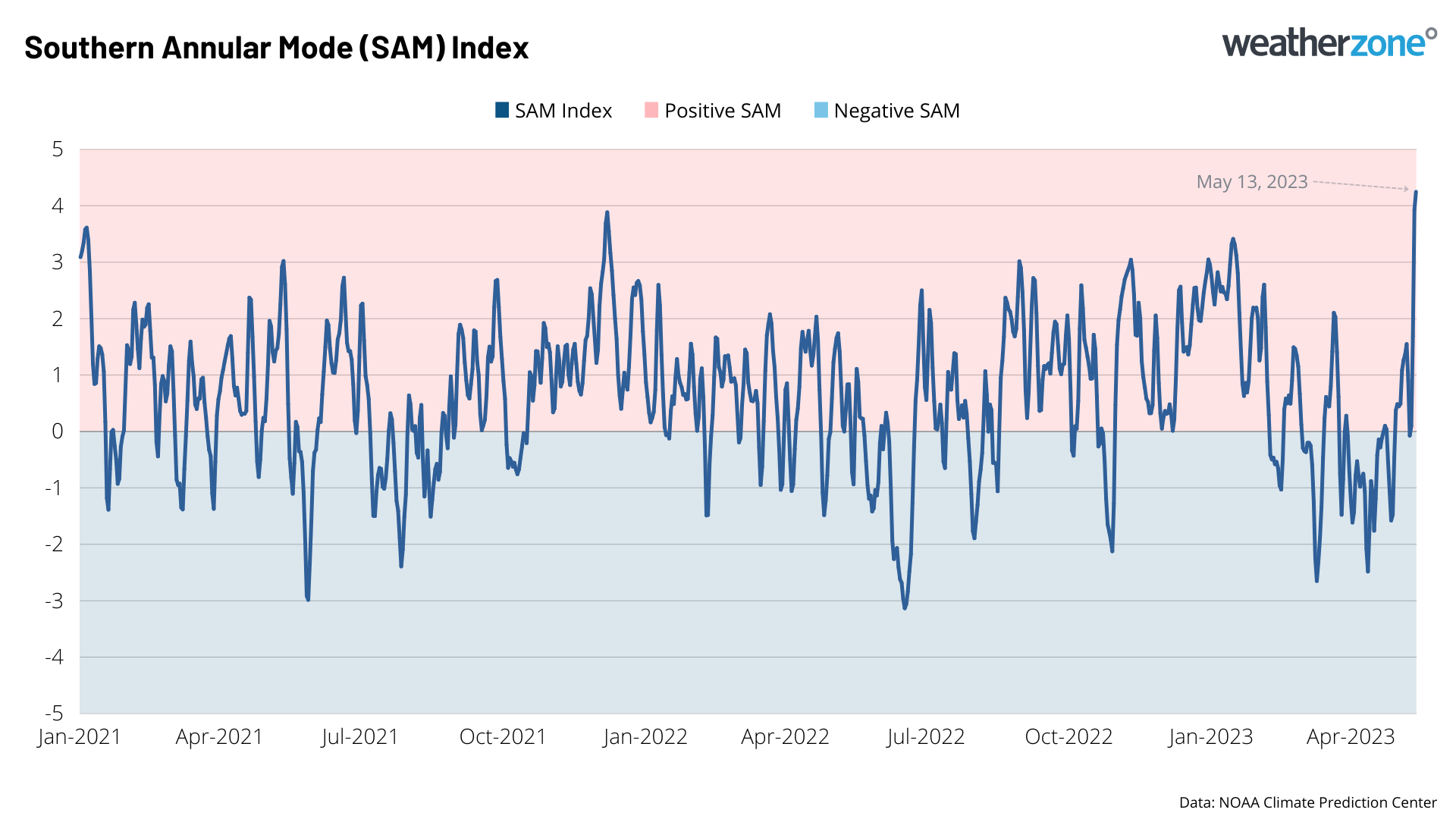
Image: Southern Annular Mode (SAM) index between January 1, 2020 and May 13, 2023.
While the SAM has less influence on Australia’s weather during autumn, the current strong negative phase may have contributed to heavy rain in southeast Qld and northeast NSW earlier this week.
It’s also worth noting that there has been an observed trend towards more positive phases of the SAM in recent decades. So, while this week’s strong positive phase may be short-lived, we may see more positive swings of the SAM in the coming weeks and months.
DTN APAC can provide tailored climate briefings, addressing climate drivers such as SAM, El Niño/La Niña and the Indian Ocean Dipole (IOD), to your business to alert you of the most likely weather conditions and hazards to look out for during the upcoming season. Now is a good time to get a good look at the forecast for winter, spring and beyond. To find out more or to book a presentation, please email apac.sales@dtn.com.