More than a month’s worth of rain could fall over parts of western QLD today, before a burst of heavy rain, damaging winds and dangerous surf develops along parts of the state’s east coast.
An upper-level trough passing eastern Australia on Thursday will cause widespread rain from northern inland NSW up to the central coast of QLD.
This system has already produced some decent rain over Central West QLD. Durung the 24 hours ending at 9am on Thursday, Mount Moffatt received 51 mm and Charleville collected 25 mm. This is around one month’s rain at Charleville at this time of year.

Image: Composite visible satellite and radar image captured at 10:50am AEST on Thursday, showing thick clouds and rain from central QLD down to northern NSW.
Areas between about Bourke and Rockhampton could see another 20 to 40 mm of rain on Thursday, with isolated totals possibly exceeding 50 mm. This should see other parts of QLD collecting their entire July monthly average rainfall in just one day.
Showers will also increase over coastal districts in southern QLD and northern NSW on Thursday into Friday morning as onshore winds begin to strengthen due to a low pressure system developing over the Coral Sea.

Image: Forecast accumulated rain on Thursday, July 21, according to the ECMWF-HRES model.
On Friday, the upper-level trough will move further east and cause the Coral Sea low to deepen off southeast QLD.
The combination of this upper-trough and deepening surface low will produce rain, blustery winds and damaging winds and dangerous surf in parts of southeast QLD and northeast NSW from Friday.
Showers are likely to affect a broad area of the coast and adjacent inland in southern QLD and northeast NSW on Friday, before easing on Saturday. Falls should reach around 10-20 mm near the coast on Friday, with isolated falls above 30mm.
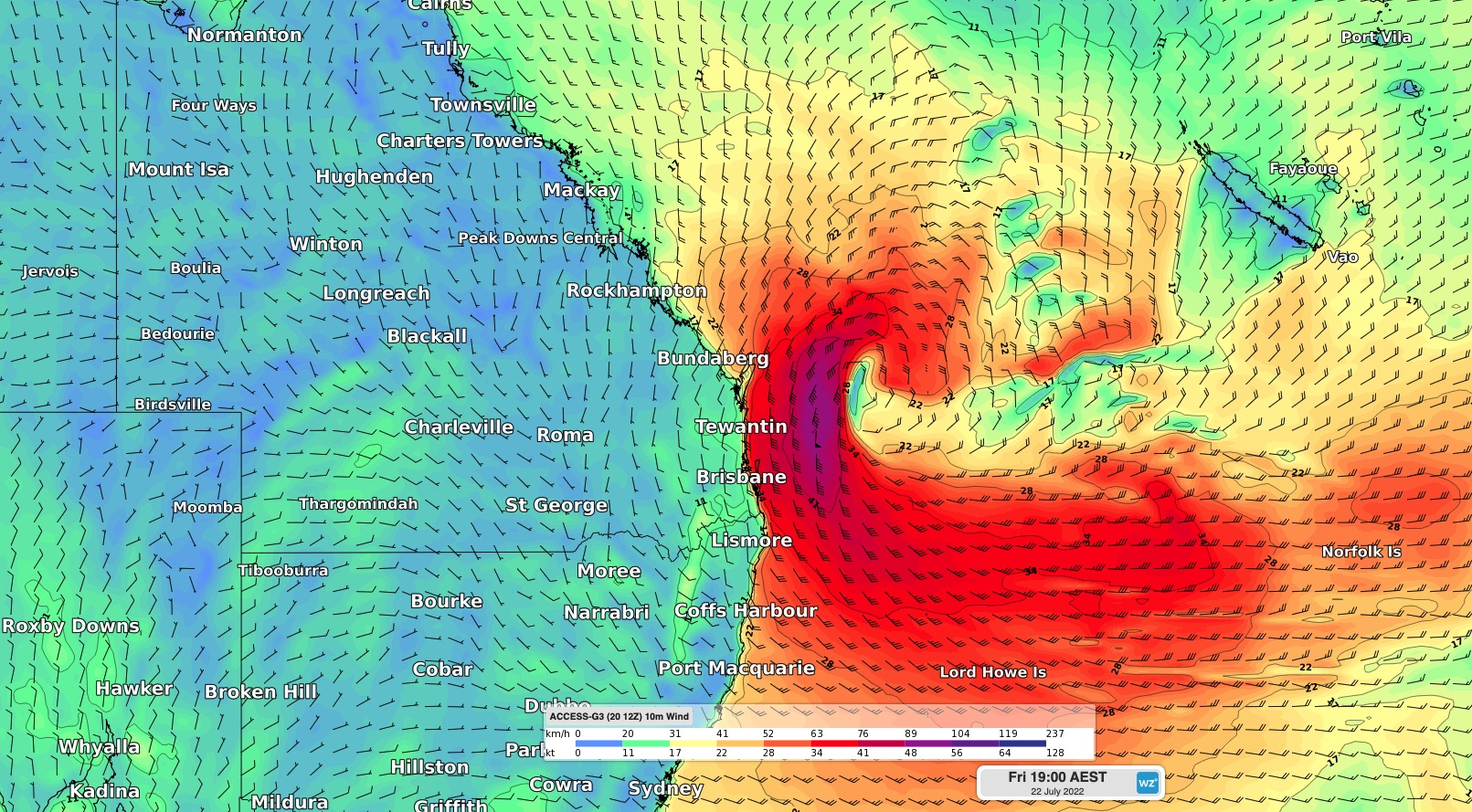
A severe weather warning has been issued for damaging winds along the southeast coast of QLD on Friday, where sustained wind speeds of 55 to 65km/h and gusts to 90 km/h are possible. At this stage, these winds are expected to ease from Saturday morning as the low moves away from the coast.

Image: Forecast sustained (10-minute) wind speed and direction on Friday evening, according to the ACCESS-G model.
A separate warning has also been issued for damaging surf in southeast QLD and northern NSW on Friday and Saturday.
Be sure to keep an eye on the latest forecasts and warnings over the next two days as this is a dynamic system and a small change in the location of the low can have a big impact on the weather. For more information on Weatherzone’s wind, surf and heavy rainfall forecasts and alerts, please contact us at apac.sales@dtn.com.


