Prosper in a dynamic world
Search

Rain returning to flood-weary NSW, Vic and Qld

Rain and thunderstorms will spread over southeastern and eastern Australia during the next three days, dumping more water into already flooded rivers across several states.

Since the beginning of September, a series of rain and storm-bearing low pressure troughs have delivered two-to-four months’ worth of rain in parts of eastern Australia.

This frequent and substantial rainfall has caused flooding in several states, with numerous flood warnings currently in place from southern Qld down to northern Vic, including a large swathe of NSW.

The map below shows the month-to-date rainfall percentages, with blue shading representing areas that have already seen more than 200 percent of their average rainfall so far this month.

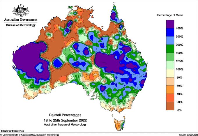
Image: Observed September month-to-date rainfall percentages. Source: Bureau of Meteorology.

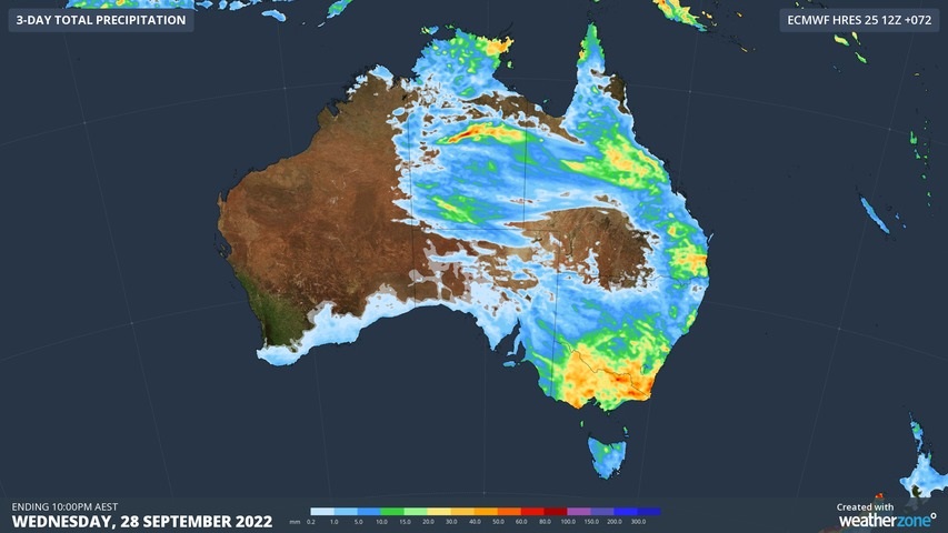
A cut-off upper-level low and an associate surface trough will interact with moisture-laden air to cause widespread showers and storms in parts of SA, NSW, the ACT, Qld, Vic, Tas and the NT between now and Wednesday.

The heaviest rain from this system is likely to fall over Vic and southern NSW, where renewed river level rises may cause flooding. There is also potential for severe thunderstorms in several states during the next three days.

Image: Forecast accumulated rain between Monday and Wednesday according to the ECMWF-HRES model.

Be sure to check the latest flood and thunderstorm warnings for the most up-to-date information as this event unfolds.

For more information on our products or how we can help you with your business needs, please contact us at apac.sales@dtn.com

Latest news

Satisfy your weather obsession with these news headlines from around the nation, and the world.

Costly aviation delays and diversions at Bali Airport with intense thunderstorms

Intense and out-of-season thunderstorms led to significant delays and diversions at Bali’s International Airport this past Sunday. The satellite loop below shows thick thunderstorm clouds across the Indonesian islands of Lombok, Bali and Java on Sunday. Video: Enhanced infrared satellite imagery showing intense thunderstorm activity across Bali and surrounding areas on the evening of Sunday, […]

How is DTN APAC equipped to service the offshore wind farm industry?

Wind turbines are usually pictured on rolling hills far from cities and people, but what if they were on rolling swells off the coast of populated areas? Australia’s National Electricity Market (NEM) and WA renewable power network currently harnesses wind power from 115 wind farm facilities and a capacity of 15,617 MW, according to OpenNEM. […]

Quarter million lightning strike and heavy downpours smash southwest WA businesses

The southwestern tip of Western Australia is the latest corner of the country to see exceptionally heavy winter rainfall, with 24-hour totals topping 100mm at some locations, and over 250,000 lightning strikes causing costly shutdown procedures. Storms and heavy downpours pelted much of the South West Land Division on Wednesday as a cold front and […]

East Coast Low brings intense night of wind, rain and surf to NSW businesses

The East Coast Low lashed large parts of the NSW coastline in the 24 hours to Wednesday morning as damaging to destructive winds, intense rainfall and large waves disrupted industries from aviation to ports, and transport to power utilities. The stretch of NSW coastline from the Hunter region to the South Coast has been most […]