Prosper in a dynamic world
Search

Rain on the way for northern and eastern Australia


Unseasonably heavy rain will spread over parts of the NT and QLD later this week, with wet weather also set to return to Australia’s east coast.

Northern Australia is in the middle of its dry season, a largely rainless six-month period that runs from May to October. The map below shows that most of northwest QLD and the northern half of the NT usually receive less than 5mm of rain during all of July.

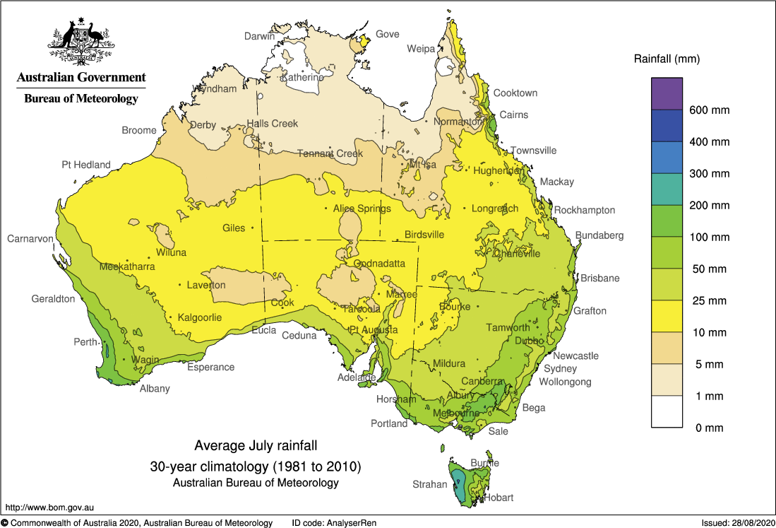
Image: Long-term average rainfall for July. Source: Bureau of Meteorology

This week, however, a stream of tropical moisture is going produce rain over a broad area of the NT and QLD, possibly delivering several months’ worth of dry-season rainfall in some areas.

A few showers will develop over the NT and far west QLD on Tuesday and Wednesday as a cloudband starts to build across northern Australia. Rain will become heavier and more widespread between Thursday and Saturday as the cloudband slowly drifts further east.

The injection of tropical moisture provided by this large cloudband will also help produce rain over a broad area of eastern Australia from Friday into the weekend, possibly persisting into the start of next week as well. There are early signs that some of this rain could become heavy enough to causef flooding as a coastal trough deepens early next week.

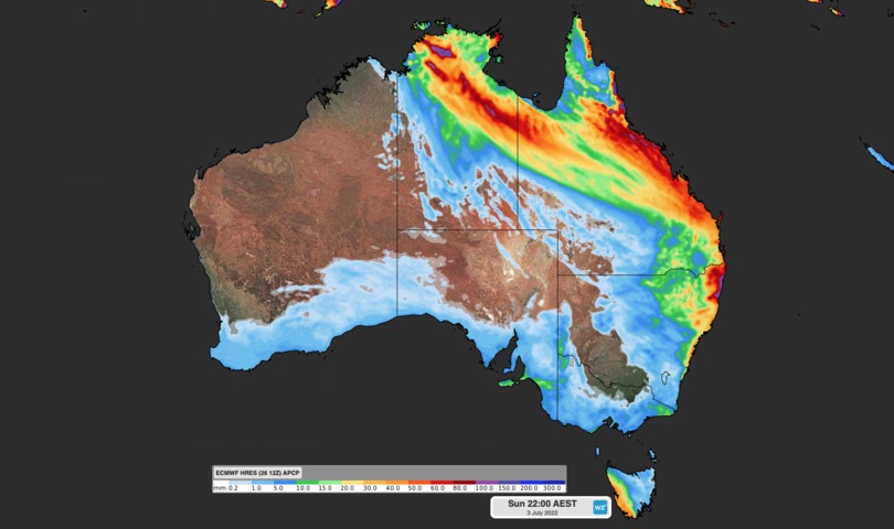
The two maps below show how much rain two different forecast models are predicting this week, from Monday to Sunday.

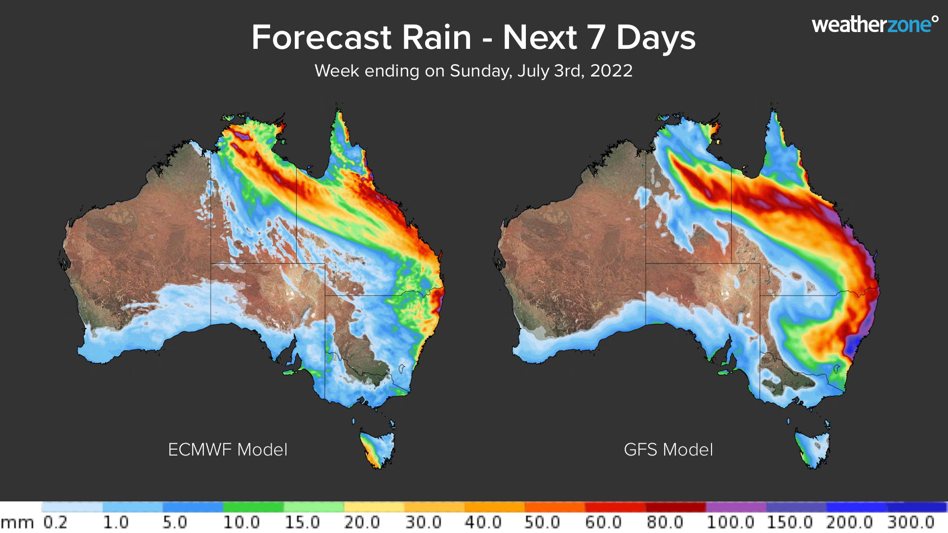
Image: Forecast accumulated rain during the 7 days ending on Sunday, July 3.

This rain event could cause flooding in parts of the NT, QLD and eastern NSW, including areas that are normally dry at this time of year. Be sure to check the latest forecasts and warnings in your area. For more information on Weatherzone’s rainfall and heavy rainfall forecasting, please contact us at apac.sales@dtn.com.

Latest news

Satisfy your weather obsession with these news headlines from around the nation, and the world.

Perth sets rainfall streak not seen in 18 years as water storage levels fall

For four months in a row, Perth has exceeded its average monthly rainfall – the first time this has happened in the traditionally wet winter and spring period since 2007. Perth reached its September average of 79.3mm during light showers on Tuesday and Wednesday. Another 13.2mm of rain then fell in the 24 hours to […]

DTN remote sensing captures rain and thunderstorms lashing Solomon Islands

Aviation, mining and shipping industries in the Solomon Islands and other South Pacific nations are often unable to use traditional radar to warn of incoming storms that disrupt operations and put workers in harm’s way. DTN APAC offers a suite of remote sensing weather solutions that give businesses and industries in remote areas around the […]

Negative Indian Ocean Dipole officially underway – here’s what it means for Australian businesses and industries

A negative Indian Ocean Dipole (IOD) event is now underway, increasing the likelihood of above average rain over large parts of Australia in the coming months. What is the Indian Ocean Dipole (IOD)? The IOD is an index used to monitor sea surface temperatures across the tropical Indian Ocean. It’s an important index for the […]

La Niña more likely this year after BoM switches to new index – what does this mean for Australian businesses?

The likelihood of La Niña occurring in 2025 has increased due to a change in the way the Bureau of Meteorology calculates sea surface temperature anomalies in the tropical Pacific Ocean. What is La Niña? La Niña refers to a distinct pattern of sea surface temperatures across the tropical Pacific Ocean. When La Niña is […]