Prosper in a dynamic world
Search

Powerful winds whipping southeastern Australia


Fierce winds will impact a large area of southeastern and eastern Australia during the next 48 hours as a wintry blast continues over the region.  

This wild and dangerous weather is being caused by a deep low pressure system in the Tasman Sea and a series of low-pressure troughs and fronts extending over southeastern Australia.  

Powerful winds will impact several states and territories on Tuesday and Wednesday, with several severe weather warnings currently in place.  

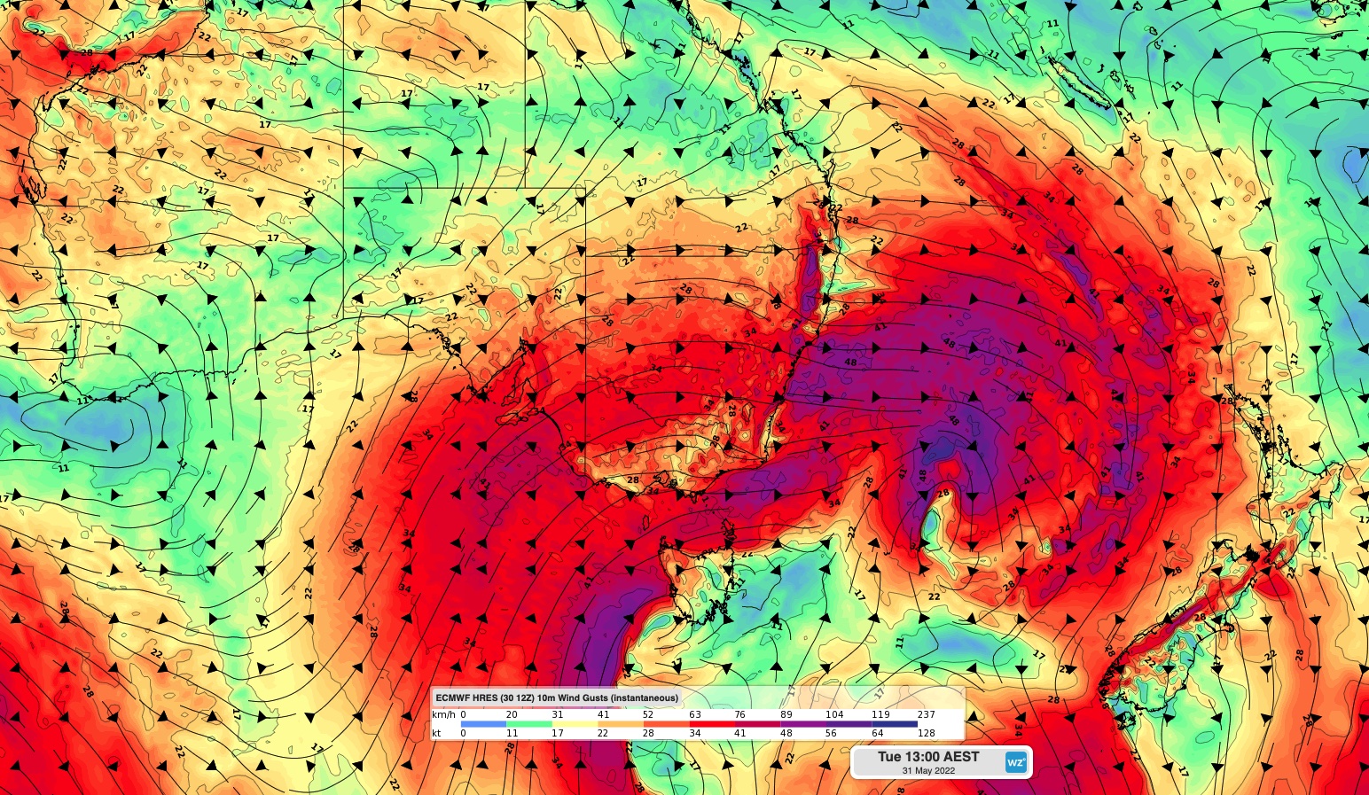
The map below shows one model’s instantaneous wind gust forecast on Tuesday afternoon, showing the broad extend of the dangerous winds from this system. 

 MicrosoftTeams-image (440)

Image: ECMWF instantaneous wind gust forecast on Tuesday afternoon. 

Severe weather warnings have been issued for damaging winds in parts of SA, VIC, eastern NSW, the ACT and southeast QLD on Tuesday. Winds across the higher ground and Hunter district in NSW could see winds averaging 50 to 70 km/h (about 38 knots), with gusts to 110 km/h. Coastal areas across Sydney and the Illawarra could see winds averaging around 45 to 65 km/h (about 35 knots), with gusts around 90 to 100 km/h.  

Damaging winds should continue into Wednesday across parts of VIC, NSW, the ACT and QLD, before easing on Thursday as a high pressure system moves across the region. 

  MicrosoftTeams-image (439)

Image: ECMWF instantaneous wind gust forecast on Wednesday afternoon. 

How can Weatherzone ensure safety and efficiency of ports?   

Weatherzone can provide accurate weather forecasts to ports up to 7 days in advance. This enables ports to effectively plan their operations days ahead, ensuring safety and productivity.  

We recognise that each day in the port is different, due to changes in vessel sizes and unloading jobs and provide detailed forecasts and consultancy to ports.    

For more information, please contact us at apac.sales@dtn.com.   

Latest news

Satisfy your weather obsession with these news headlines from around the nation, and the world.

High tropical cyclone risk near northern Australia this week

A tropical low currently developing over the Timor Sea has a high chance of becoming a tropical cyclone later this week, with a possibility of landfall somewhere in the Northern Territory or Western Australia. Key industries could be impacted including Ports, Mining, Transport, and Agriculture. The satellite images below show cloud circulating around the developing […]

Madden-Julian Oscillation increasing tropical cyclone potential for northern Australia industries

Sea surface temperatures exceeding 31°C off the coast of northern Australia and an active phase of the Madden-Julian Oscillation (MJO) are increasing the likelihood of early-season tropical cyclone activity, with hints of the season’s first tropical cyclone coming as early as next week. Tropical cyclones require sea surface temperature of 26.5°C or warmer to develop, […]

Tropical cyclone season begins with warm oceans surrounding northern Australia

The 2025-26 tropical cyclone season has begun with abnormally warm oceans surrounding northern Australia, signalling an increased risk for severe tropical cyclones in the coming months. The Australian tropical cyclone season runs from November 1 to April 30. During this six-month period, there are usually about 9 to 10 tropical cyclones in the Australian region, […]

7.8 million lightning pulses detected by DTN’s Total Lightning Network over Australia in one week

A barrage of thunderstorms battered large areas of eastern and northern Australia over the past week, producing close to 8 million lightning pulses across the country and more than 4 million over Queensland alone. DTN’s Total Lightning Network (TLN) detected around 7.79 million lightning pulses above Australia last week. This lightning was observed over every […]