Prosper in a dynamic world
Search

One month’s rain soaks Gold Coast overnight

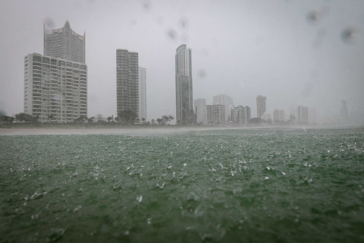
Parts of southeast Qld just received more than a month’s worth of rain in 24 hours, with some areas on the Gold Coast collecting around 100 mm in six hours overnight.

A low pressure trough and developing low pressure system produced thick clouds and widespread rain across southeast Qld and northeast NSW during Monday night into Tuesday morning.

Video: Radar imagery showing observed rainfall over southeast Qld and northeast NSW between Monday afternoon and Tuesday morning.

Most places to the east of a line from Gympie to Goondiwindi and north of Lismore received 30 to 80 mm of rain during the 24 hours to 9am on Tuesday.

A focussed area of heavy rain inundated the Gold Coast and Tweed Coast and adjacent hinterland, where numerous rain gauges received 100 to 150 mm during this period.

The heaviest falls during the 24 hours ending at 9am on Tuesday included 168 mm at Loder Creek Dam, 158 mm at Molendinar and 151 mm at Biggera Ck Dam.

Coolangatta’s 117 mm in this period was its heaviest daily total in May since 1990. The Gold Coast Seaway also picked up 116 mm to 9am on Tuesday, its wettest May day since 2003.

On the NSW side of the border, Byron Bay’s 53.2 mm up to 9am Tuesday was half a month’s worth of rain for this time of year.

While rain has been intense in some areas, this is only a short-lived event. Drier weather had already returned to most areas of southeast Qld and northeast NSW by Tuesday morning and the last of the rain should clear off the coast by the afternoon.

DTN APAC’s meteorologists can provide special, short-notice weather briefings when severe weather is expected for your business, explaining what will happen and its impact on you business. To find out more, please email us at apac.sales@dtn.com.

Latest news

Satisfy your weather obsession with these news headlines from around the nation, and the world.

How Australian East Coast port and maritime operations could be disrupted by tropical cyclones over the next two weeks

Port and maritime operations across Australia’s East Coast could be disrupted by increased tropical cyclone activity in the Coral Sea and southwest Pacific Ocean over the next two weeks. Meteorologists reference a large selection of Numerical Weather Prediction (NWP) models to forecast weather. A number of these NWP models are forecasting the development of tropical […]

Extreme fire danger and severe heatwave conditions spreading across SA, Victoria and NSW

Hot, dry and windy weather causing elevated fire danger and severe heatwave conditions are sweeping across southeastern Australia over the next three days, driving high energy demand and disruption to operations. Clear skies associated a large and slow-moving high pressure system have allowed hot air to build up over parts of northern, western and central […]

Heightened bushfire risk during the 2025-26 summer for WA, Victoria and NSW in latest AFAC Outlook

The Australian and New Zealand Council for fire and emergency services (AFAC) identified western and southern WA, Victoria and inland NSW as key regions that are at risk of heightened bushfire risk this summer. Parts of Australia have experienced severe soil moisture and rainfall deficiencies over the past months and years, while high fuel loads […]

Southeast Asia hit by deadly widespread flooding with three tropical cyclones, including rare Malacca Strait cyclone

Three tropical cyclones: Senyar, Koto and Ditwah, have brought widespread deadly flooding to parts of southeast Asia over the past week, including Indonesia, Malaysia, Thailand, the Philippines and Sri Lanka. Extensive disruptions to industries, government and communities is expected as the rescue, clean up and recovery extend over the coming months. Senyar brings devastation to […]