Prosper in a dynamic world
Search

Darwin on tropical cyclone watch

A tropical cyclone watch has been issued for Darwin as a low-pressure system gains strength in the Timor Sea.

The satellite image below shows clouds building over the Timor Sea on Thursday, associated with a developing Tropical Low.


darwin cyclone
Image: Enhanced visible/infrared satellite image showing cloud building around a developing tropical low to the west of Darwin on Thursday.

Forecast models suggest that this low will gain strength over the next 48-72 hours and could start moving towards the western Top End from Friday.

At this stage, the low is expected to develop into a category one tropical cyclone on Friday and may become a category two cyclone over the weekend.

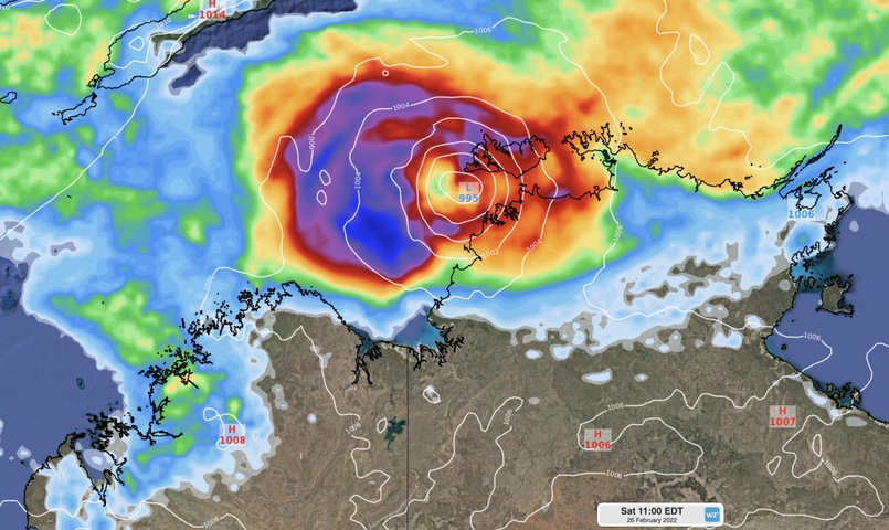
The initial track map issued by the Bureau of Meteorology suggests that tropical cyclone could move towards Darwin as it gains strength over the weekend. However, there is a high amount of uncertainty regarding the future movement of this system and it may track further south, towards WA’s Kimberley coast.


darwin
Image: The first tropical cyclone track map issued for this system by the Bureau of Meteorology.

A tropical cyclone watch has been issued between Point Stuart and Kalumburu, including Darwin.

You can find the latest tropical cyclone warnings here.

For more information on Weatherzone’s tropical cyclone forecasting, please contact us at apac.sales@dtn.com.

Latest news

Satisfy your weather obsession with these news headlines from around the nation, and the world.

DTN Dangerous Thunderstorm Alerts in action with severe thunderstorms disrupting Perth industries

Severe thunderstorms impacted southwest WA and the Perth region on Sunday, December 14, 2025, triggering Dangerous Thunderstorm Alerts (DTA) by DTN for industries and businesses in the region. DTN operates Dangerous Thunderstorm Alerts (DTA) which alert businesses and industries to thunderstorms based on intensity and movement. These alerts provide advanced notice of thunderstorms moving into […]

How Australian East Coast port and maritime operations could be disrupted by tropical cyclones over the next two weeks

Port and maritime operations across Australia’s East Coast could be disrupted by increased tropical cyclone activity in the Coral Sea and southwest Pacific Ocean over the next two weeks. Meteorologists reference a large selection of Numerical Weather Prediction (NWP) models to forecast weather. A number of these NWP models are forecasting the development of tropical […]

Extreme fire danger and severe heatwave conditions spreading across SA, Victoria and NSW

Hot, dry and windy weather causing elevated fire danger and severe heatwave conditions are sweeping across southeastern Australia over the next three days, driving high energy demand and disruption to operations. Clear skies associated a large and slow-moving high pressure system have allowed hot air to build up over parts of northern, western and central […]

Heightened bushfire risk during the 2025-26 summer for WA, Victoria and NSW in latest AFAC Outlook

The Australian and New Zealand Council for fire and emergency services (AFAC) identified western and southern WA, Victoria and inland NSW as key regions that are at risk of heightened bushfire risk this summer. Parts of Australia have experienced severe soil moisture and rainfall deficiencies over the past months and years, while high fuel loads […]