The Australian region is going to see a volatile mix of weather this week, including heavy rain, thunderstorms, flooding, heatwaves, bushfires and possibly a tropical cyclone or two.
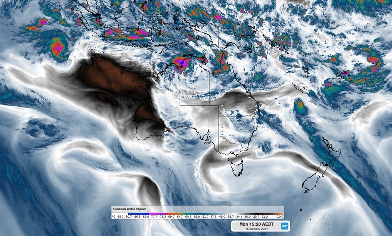
An active monsoon trough, a large pool of hot air, abnormally warm sea surface temperatures around Australia, and the passage of a cut-off upper-level low pressure system will all contribute to a dynamic week of weather in Australia this week.
Rain will be one of the main features on the forecast for many locations in northern and eastern Australia over the next seven days, thanks to the monsoon trough in the tropics and moisture-laden air flowing in from the Coral and Tasman Seas.
The map below shows how much rain one computer model is predicting over Australia this week combined.
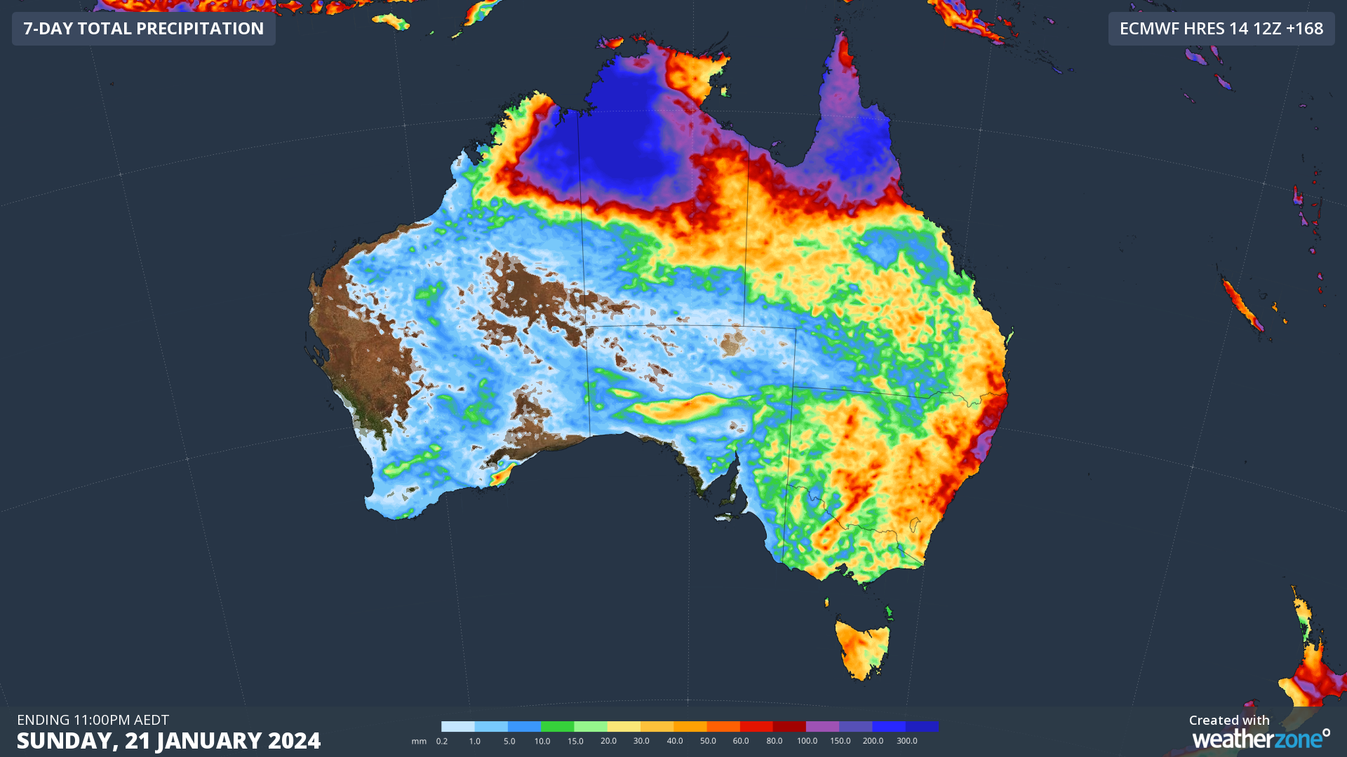
Image: Forecast accumulated rain during the seven days ending on Sunday, January 21, 2024.
The heaviest rain during the next seven days will fall over the NT and northeast Kimberley, driven by a near-stationary topical low. This low is expected to remain over land near the base of the Top End for most of the week, dumping days of torrential rain. Some models predict well over half a metre of rain in parts of the NT this week, with accumulated totals over 1,000 mm not out of the question. Port Keats (Wadeye) received a whopping 334.8 mm during the 24 hours to 9am on Monday, which was its 2nd heaviest daily rainfall on record.
Persistent rain and storms will also soak Queensland’s northern tropics this week, adding more water to already sodden catchments following an exceptionally wet December.
Flood watches have been issued for some northern parts of the NT and Qld in response to the monsoon rain expected this week. A severe weather warning has also been issued for heavy rain and damaging winds in parts of the NT.
Rain and thunderstorms are also likely to develop over a broad area of southern and southeastern Australia between now and Thursday, mainly due to the passage of an upper-level low and associated trough. This outbreak of wet and stormy should feature some severe thunderstorms and may cause pockets of flooding.
While a few showers and thunderstorms will also hit some parts of central and western Australia this week, the main story in the west will be heat.
A mass of hot air will linger over the nation’s west and northwest this week, partially in response to the persisting presence of the tropical low over the NT.
This hot air will cause a low-intensity to severe heatwave for large areas of WA this week, with a few places expected to see an extreme heatwave. There are early signs that temperatures could nudge 50°C in the Pilbara region towards the end of this week or early next week.
Some hot air will also be carried into southwestern Australia over the next few days by a low pressure trough. Perth is forecast to continue its recent run of hot weather on Monday and Tuesday, before cooler westerly winds develop from Wednesday.
This week’s lingering hot weather will contribute to elevated fire danger ratings across much of the state this week, including the fire-affected area near Gin Gin to the northeast of Perth. High fire danger is predicted over most of WA during the next several days, with locally extreme fire danger expected in some areas.
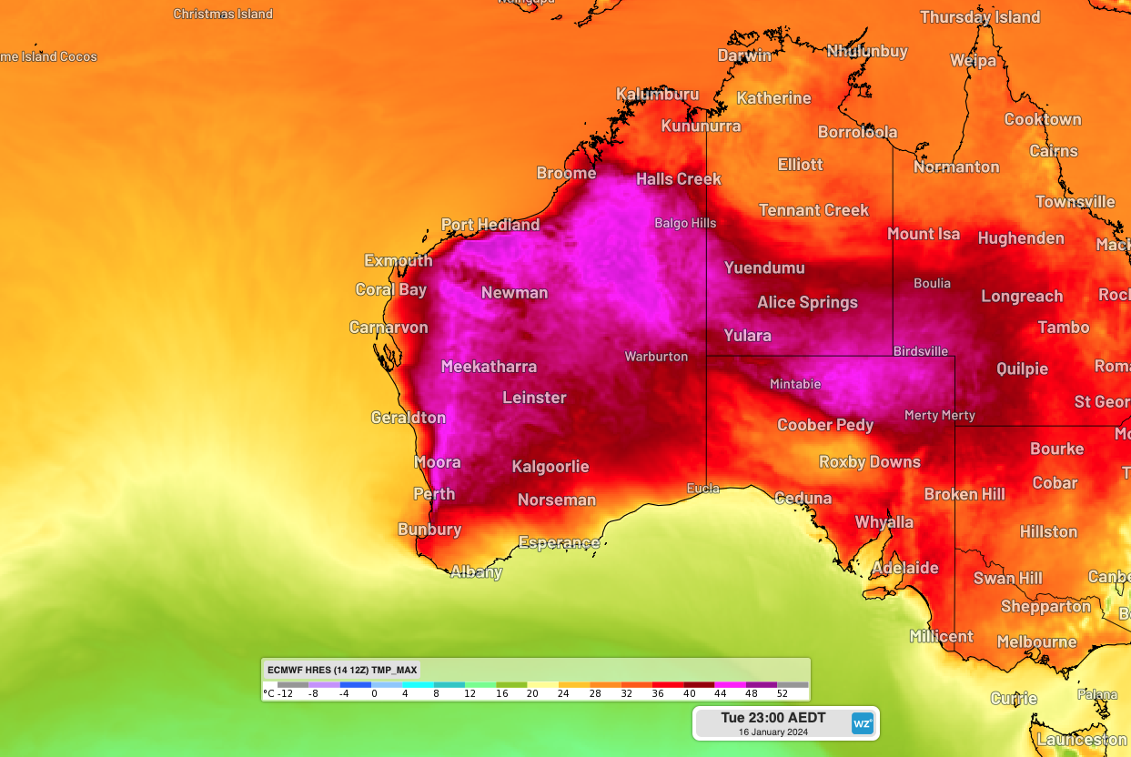
Image: Forecast maximum temperature on Wednesday, January 17, 2024, according to the ECMWF-HRES model.
Another thing to watch in the Australian region this week will be the potential for tropical cyclone development. The presence of an active monsoon trough increases the likelihood of tropical cyclone formation near Australia.
There is a high chance that a tropical cyclone will develop near the Cocos (Keeling) Islands in the middle of this week. There are also indications that another tropical cyclone could form over the Coral Sea towards the end of this week or early next week.
The next two tropical cyclones to be named inside Australia’s area of responsibility will be named Kirrily and then Lincoln.
DTN APAC has all of your weather forecasting, nowcasting and post-event weather needs covered. To find out more, please email us at apac.sales@dtn.com.


