Prosper in a dynamic world
Search

Albury’s heaviest rain in 160 years


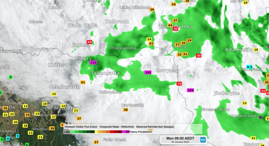
Relentless rain has fallen along parts of the NSW-Vic border during the past 24 hours, with Albury registering its wettest day since 1863.

A near-stationary band of heavy rainfall developed along a convergence line in the Albury-Wodonga region of southern NSW and northeast Vic on Sunday night.

This deluge, which was being fuelled by a mass of unusually humid air, produced an entire summer’s worth of rain in just 24 hours at some locations.

Video: Composite radar, satellite and rainfall observations during the 24 hours ending at 9am on Monday, January 30, 2023.

Albury Airport collected 132 mm during the 24 hours ending at 9am on Monday. This is Albury’s wettest day since 1863 and roughly equal to its long-term seasonal summer average of 135 mm. Some of the most intense rain fell overnight, with 65mm hitting the gauge during the 6 hours ending at 2am on Monday.

Albury has one of Australia’s longest available periods of records for rainfall, with data stretching back to 1858. This past 24 hour’s rain was the 2nd highest daily total in this lengthy period, beaten only by 167.6 mm from April 1 in 1863.

Nearby, the 134 mm of rain that fell at Hume Dam during the 24 hours to 9am on Monday, which was its highest daily total in records dating back to 1922.

Across the border in northeast Vic, Hunters Hill picked up 149.6 mm in the same period, including 48.4 mm in just three hours.

Showers will ease over southern NSW and northern Vic as a low pressure trough moves further north, away from the region.

Latest news

Satisfy your weather obsession with these news headlines from around the nation, and the world.

Negative Indian Ocean Dipole officially underway – here’s what it means for Australian businesses and industries

A negative Indian Ocean Dipole (IOD) event is now underway, increasing the likelihood of above average rain over large parts of Australia in the coming months. What is the Indian Ocean Dipole (IOD)? The IOD is an index used to monitor sea surface temperatures across the tropical Indian Ocean. It’s an important index for the […]

La Niña more likely this year after BoM switches to new index – what does this mean for Australian businesses?

The likelihood of La Niña occurring in 2025 has increased due to a change in the way the Bureau of Meteorology calculates sea surface temperature anomalies in the tropical Pacific Ocean. What is La Niña? La Niña refers to a distinct pattern of sea surface temperatures across the tropical Pacific Ocean. When La Niña is […]

Southern Hemisphere’s polar vortex is weakening – here’s what this means for Australian weather

Stratospheric warming high above Antarctica could cause the Southern Hemisphere’s polar vortex to weaken at an unusually fast pace over the coming weeks. This weakened polar vortex has the potential to affect weather patterns across Australia and other parts of the Southern Hemisphere. What is the polar vortex? The polar vortex is a large circulating […]

Severe thunderstorms, tornadoes and flooding rainfall lash out over NSW businesses and industries

Severe thunderstorms, tornadoes and flooding rainfall have disrupted transport, rail, aviation and many other industries across NSW as a low pressure system tracked over the state. Severe thunderstorms and tornadoes in western NSW A tornado was observed near the town of Young on the South West Slopes of New South Wales around 3:30pm on Wednesday […]