Widespread severe thunderstorms, 45°C heat, extreme fire danger and total fire bans are impacting Australian industries, such as mining, aviation, transport, energy and insurance, this week.
A 2,000 km long line of thunderstorms
A nearly 2,000 km long line of thunderstorms could be seen on the DTN APAC Stormtracker dashboard on Tuesday.
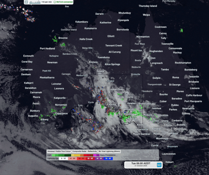
Image: Satellite imagery, radar and DTN’s Total Lightning Network (TLN) across Australia on Tuesday, October 21, 2025.
This expansive area of thunderstorms formed along a broad low pressure trough spanning from the Kimberley in WA, across the southern NT and SA, into the Great Australian Bight. Continuous lines of thunderstorms that march across the landscape pose a great threat to outback industries as they cannot be avoided. DTN’s TLN, Stormtracker and Squall Alerting help give businesses up to 3 hours of preparation time ahead of impending storms.
Across Tuesday, over 300,000 lightning strikes were reported across the remote Australian outback.
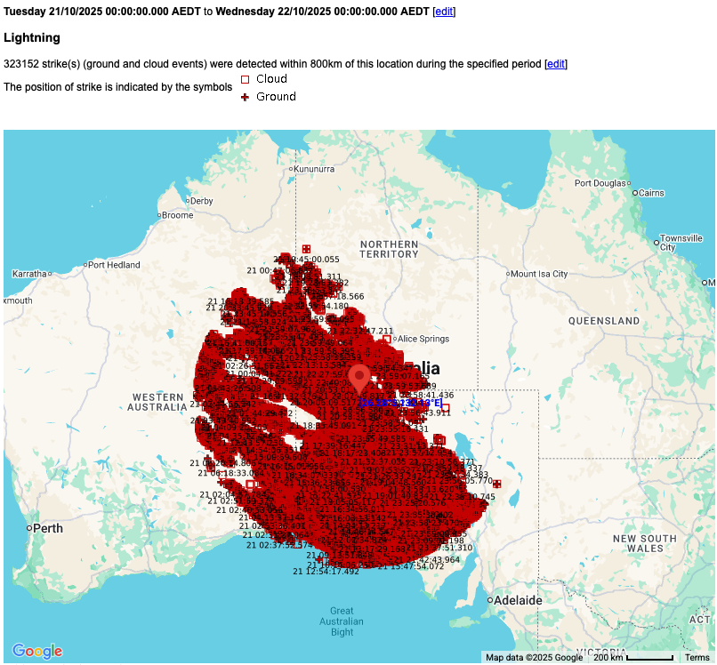
Image: DTN’s TLN detected over 300,000 lightning strikes within 800 km of Pukatja, SA on Tuesday, October 21, 2025.
Australia operates over 60 radar sites, each with a typical coverage radius of about 200 km. This still leaves broad areas of the Australian outback outside of traditional radar coverage – keeping industries like agriculture or aviation unaware of heavy rain or thunderstorms over the interior. DTN remote sensing and now-casting solutions offer increased visibility across these blind spots, helping airlines carry the right amount of extra fuel to get around thunderstorms and safely get to the intended destination.
Even without reliable rainfall observations or radar data, DTN’s Oracle satellite derived now-casting can report rainfall across remote locations in Australia and worldwide.
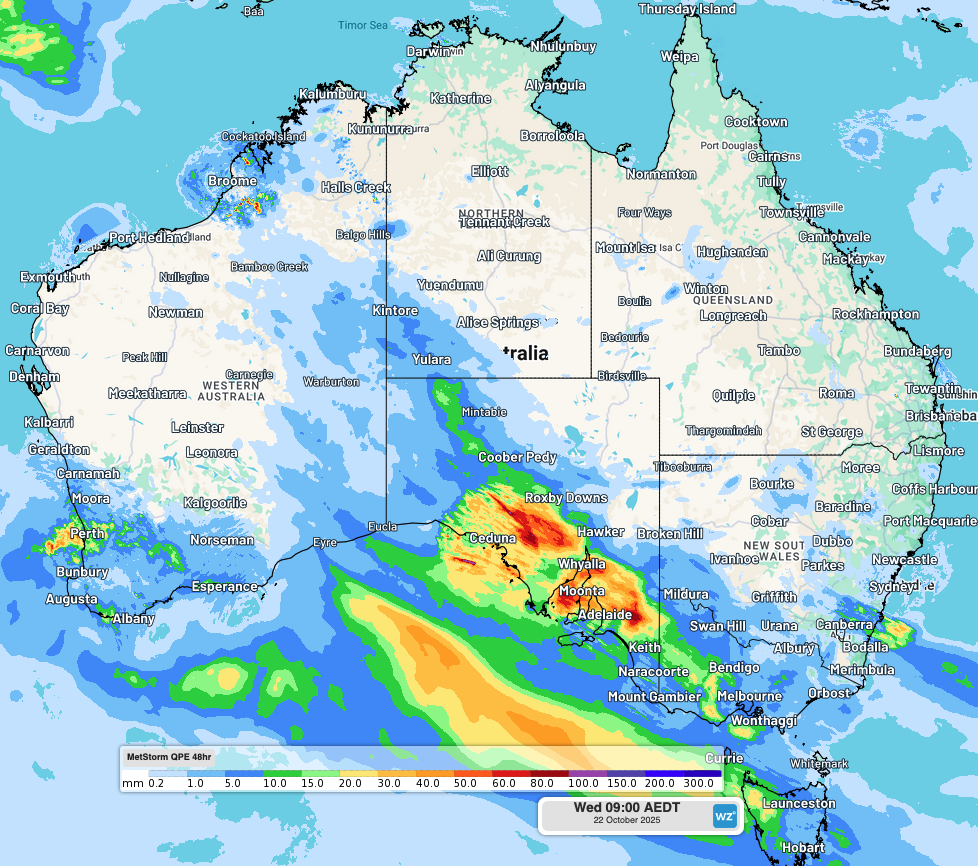
Image: DTN’s Quantitative Precipitation Estimate (QPE) showing rainfall that has fallen over the past two days across the region.
45°C heat, severe heatwave, extreme fire danger and total fire bans
Ahead of this low pressure trough, intense heat is concentrating into eastern states. On Tuesday, long-standing statewide heat records were broken in Queensland and New South Wales.
Birdsville in Queensland’s Channel Country reached a maximum temperature of 46.1°C. Remarkably, that’s a full degree above the previous state October record of 45.1°C, which also occurred in Birdsville in 1995, with records going back well over a century to 1892.
Bourke in the Upper Western forecast district of New South Wales reached 44.8°C at 4pm. That broke the old NSW state record for October of 43.9°C at Brewarrina in 1919 by almost a degree.
Tuesday’s site (but not statewide) records also include:
- Thargomindah in far southwest Queensland reached 45.1°C just after 3pm. That beat its old record of 43.1°C by two degrees, in records going all the way back to 1879.
- Tibooburra in the far northwest corner of NSW reached 42.8°C – its hottest day in records going back to 1886. The “old” record of 42.6°C set on Monday lasted just a day.
Low-intensity to severe heatwave conditions are currently affecting outback parts of Queensland and NSW between Monday and Wednesday. Heat will concentrate over WA’s Kimberley, the NT and Queensland in the days to come, with severe-to-extreme heatwave ratings extending later this week into the weekend.
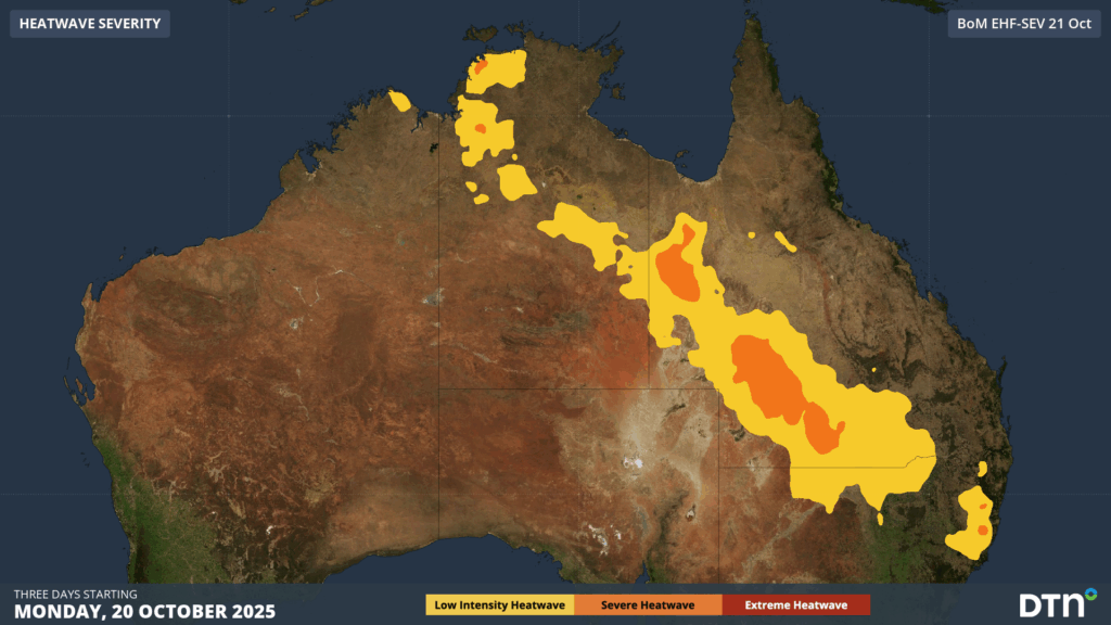
Image: Low-intensity to Severe Heatwave ratings issued by the Bureau of Meteorology for heatwave conditions between Monday and Wednesday, October 20-22, 2025.
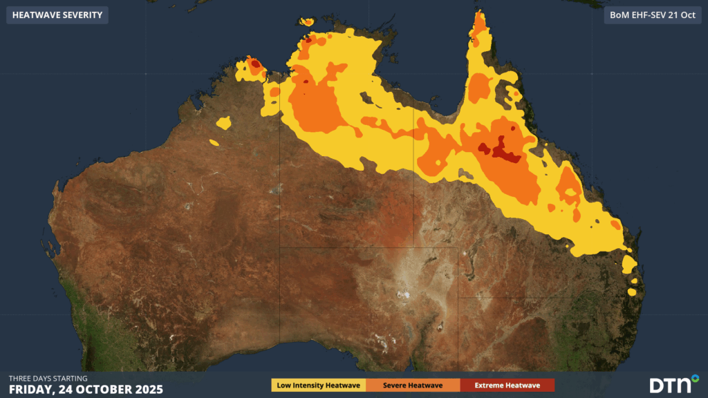
Image: Severe-to-Extreme Heatwave ratings issued by the Bureau of Meteorology for heatwave conditions between Friday and Sunday, October 24-26, 2025.
This sweltering inland heat being flushed into NSW on Wednesday is combining with fresh and gusty northwesterly winds, resulting in Extreme fire danger ratings and Total Fire Bans for parts of central and eastern NSW.
Read more: Extreme fire weather to hit NSW industries and businesses on Wednesday
How DTN’s remote sensing and now-casting solution are helping fill the gaps in traditional radar coverage across remote mining, transport and agricultural areas during the build-up season
Australia is a vast country with densely populated coastal areas across the south and east, and millions of square kilometres of sparsely populated and rich in resources elsewhere. Typical radar coverage extends to a radius of about 200km, however mountains, trees and towers can restrict this optimal coverage range. Even with over 60 radar sites operating across Australia, vast expanses of the outback and WA remain outside of this traditional radar coverage, as seen in the left image below.
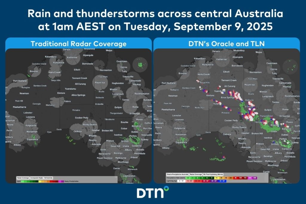
Image: Comparison of traditional radar coverage and detected rainfall (left), and DTN’s Oracle and TLN (right), across Australia at 1am AEST on Tuesday, September 9, 2025.
The image on the right shows DTN’s Oracle rainfall and Total Lightning Network detecting a vast area of rain and thunderstorms that would have been missed by traditional detection methods.
DTN Oracle
High-Resolution Modelling
Oracle is a satellite-derived, gridded nowcasting system. It forecasts out to 3 hours at a 1-2km resolution, and rapid updates every 5 minutes. With this enhanced forecasting detail, Oracle has the upper hand over 9-12km resolution models when capturing temperature, lightning, cloud cover, wind and rainfall. This ensures that no matter where you are in Australia, you will have access to precision nowcasting and forecasting that can rapidly inform your critical business decisions.
Greater Situational Awareness
Working in conjunction with DTN APAC’s Stormtracker GIS system, Oracle provides full situational awareness of any severe weather event that presents risk to your business. Short-term forecasting and severe weather alerts enable you to foresee the intensity and duration of events, so you can prioritise the safety and preparation of your staff and assets.
Whatever the weather, we provide the insights to help keep you and your team safe, productive and profitable.
DTN Total Lightning Network
Our Total Lightning Network is the intelligent lightning solution that goes above and beyond to alert lightning and increase your lead time before the storm hits.
We utilise a vast global sensor network, created with our partner Earth Networks. Over 1200 sensors in 40+ countries provide a worldwide view of both intra-cloud (IC) and cloud-to-ground (CG) lightning strikes, enabling businesses to plan and respond with the most precise insight available. Our system can detect and calculate strike locations with incredible accuracy, offering real-time lightning mapping for a comprehensive view of storm activity.
Offering unsurpassed accuracy, with real-time sensing to <200m, we integrate with your existing systems to keep your enterprise operating within your defined severe weather thresholds. Our technology also helps monitor radiation from electrical discharges and ensures every lightning flash is accounted for.
Leave nothing to chance. Be confident working outdoors with the most sophisticated lightning alerting system, delivering intelligence to any device across your business network. Whether you need a personal lightning alerting tool for individual safety or enterprise-wide monitoring, our solution is designed to emit timely alerts and protect your operations.
Learn more about our large range of industry leading products and services or email us at sales.apac@dtn.com


