
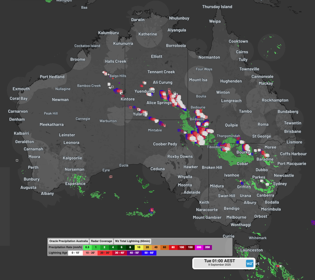
Intense and severe thunderstorms across remote and hard to reach mining areas of Australia – typically outside of traditional radar coverage, were detected by DTN’s vast network of remote sensing products.
Numerous outback locations in three states and the Northern Territory saw thunderstorms with heavy rainfall from Monday afternoon through to Tuesday morning. Notable 24-hour totals to 9am Monday totals included:
- Alice Springs received 21.4mm, which was its heaviest daily fall in September for 32 years. September is typically the second-driest month, with a monthly average of just 8.6mm. Some storm damage from wind gusts was also reported.
- Tibooburra in the far northwest corner of NSW received 31.6mm. Unusually for this very dry outpost, this was the second-highest 24-hour daily rainfall total anywhere in NSW.
- Moomba Airport in the far northeast corner of SA received 15mm, which was by far the highest 24-hour total yesterday at any South Australian weather station.
- Just over the border from Moomba, several spots in southwest Queensland received heavy falls for this time of year, including 20mm at Nappa Merrie cattle station.
The iconic outback town of Birdsville was another location in southwest Queensland to receive a decent drop. While its 24-hour total of 9.6mm wasn’t huge, it was still more rain in a day than the entire September monthly average of 8.8mm. Roads in the Cameron Corner area (where NSW, SA and Queensland meet) have been closed due to flooding.
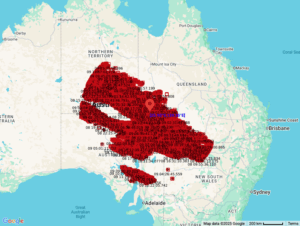
Image: Lightning strikes within 800km of Birdsville in the 36 hours to midday on Tuesday, September 9, 2025.
Birdsville’s weather was also notable for lightning (with 466,000 strikes detected within 800km of the town in the 36 hours to midday Tuesday) as well as for several wild wind gusts which reached 117 km/h early on Monday evening as the storms blew into town. Fortunately, most of the 4,000 visitors who camped last weekend for the town’s annual Birdsville Races had already packed up their tents, a logistical nightmare and huge liability for organisers if the storms hit during the event.
Why such dynamic weather in the outback?
Weatherzone meteorologist Joel Pippard pointed to the combination of heat plus tropical moisture from a northwest cloudband streaming across the continent triggered the widespread outback thunderstorms.
Video: Lightning (pink) and satellite loop in the interior of Australia on the afternoon of Monday, September 8, 2025.
Pippard added that storms were occurring even at 5am this Tuesday at some outback locations – a time of day when the weather is typically benign in early spring.
Meanwhile the likelihood of storms will increase this Tuesday afternoon in parts of southern Queensland and large parts of NSW, roughly along the line of the northwest cloudband. A stormy outbreak is also likely in parts of Victoria and southern SA in coming days, as polar air in the Southern Ocean clashes with warmer air.
If you look closely at the satellite and radar loop above, you can see the airmass with polar origins surging onto the WA coast near Esperance. Expect dynamic weather as that airmass pushes east.
How DTN’s remote sensing and now-casting solution are helping fill the gaps in traditional radar coverage across remote mining, transport and agricultural areas
Australia is a vast country with densely populated coastal areas across the south and east, and millions of square kilometres of sparsely populated and rich in resources elsewhere. Typical radar coverage extends to a radius of about 200km, however mountains, trees and towers can restrict this optimal coverage range. Even with over 60 radar sites operating across Australia, vast expanses of the outback and WA remain outside of this traditional radar coverage, as seen in the left image below.
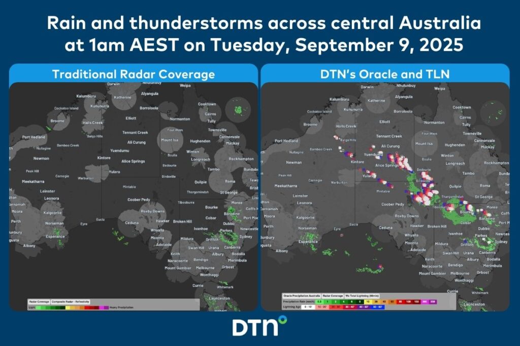
Image: Comparison of traditional radar coverage and detected rainfall (left), and DTN’s Oracle and TLN (right), across Australia at 1am AEST on Tuesday, September 9, 2025.
The image on the right shows DTN’s Oracle rainfall and Total Lightning Network detecting a vast area of rain and thunderstorms that would have been missed by traditional detection methods.
DTN Oracle
High-Resolution Modelling
Oracle is a satellite-derived, gridded nowcasting system. It forecasts out to 3 hours at a 1-2km resolution, and rapid updates every 5 minutes. With this enhanced forecasting detail, Oracle has the upper hand over 9-12km resolution models when capturing temperature, lightning, cloud cover, wind and rainfall. This ensures that no matter where you are in Australia, you will have access to precision nowcasting and forecasting that can rapidly inform your critical business decisions.
Greater Situational Awareness
Working in conjunction with DTN APAC’s Stormtracker GIS system, Oracle provides full situational awareness of any severe weather event that presents risk to your business. Short-term forecasting and severe weather alerts enable you to foresee the intensity and duration of events, so you can prioritise the safety and preparation of your staff and assets.
Whatever the weather, we provide the insights to help keep you and your team safe, productive and profitable.
DTN Total Lightning Network
Our Total Lightning Network is the intelligent lightning solution that goes above and beyond to alert lightning and increase your lead time before the storm hits.
We utilise a vast global sensor network, created with our partner Earth Networks. Over 1200 sensors in 40+ countries provide a worldwide view of both intra-cloud (IC) and cloud-to-ground (CG) lightning strikes, enabling businesses to plan and respond with the most precise insight available. Our system can detect and calculate strike locations with incredible accuracy, offering real-time lightning mapping for a comprehensive view of storm activity.
Offering unsurpassed accuracy, with real-time sensing to <200m, we integrate with your existing systems to keep your enterprise operating within your defined severe weather thresholds. Our technology also helps monitor radiation from electrical discharges and ensures every lightning flash is accounted for.
Leave nothing to chance. Be confident working outdoors with the most sophisticated lightning alerting system, delivering intelligence to any device across your business network. Whether you need a personal lightning alerting tool for individual safety or enterprise-wide monitoring, our solution is designed to emit timely alerts and protect your operations.
Learn more about our large range of industry leading products and services or email us at sales.apac@dtn.com




