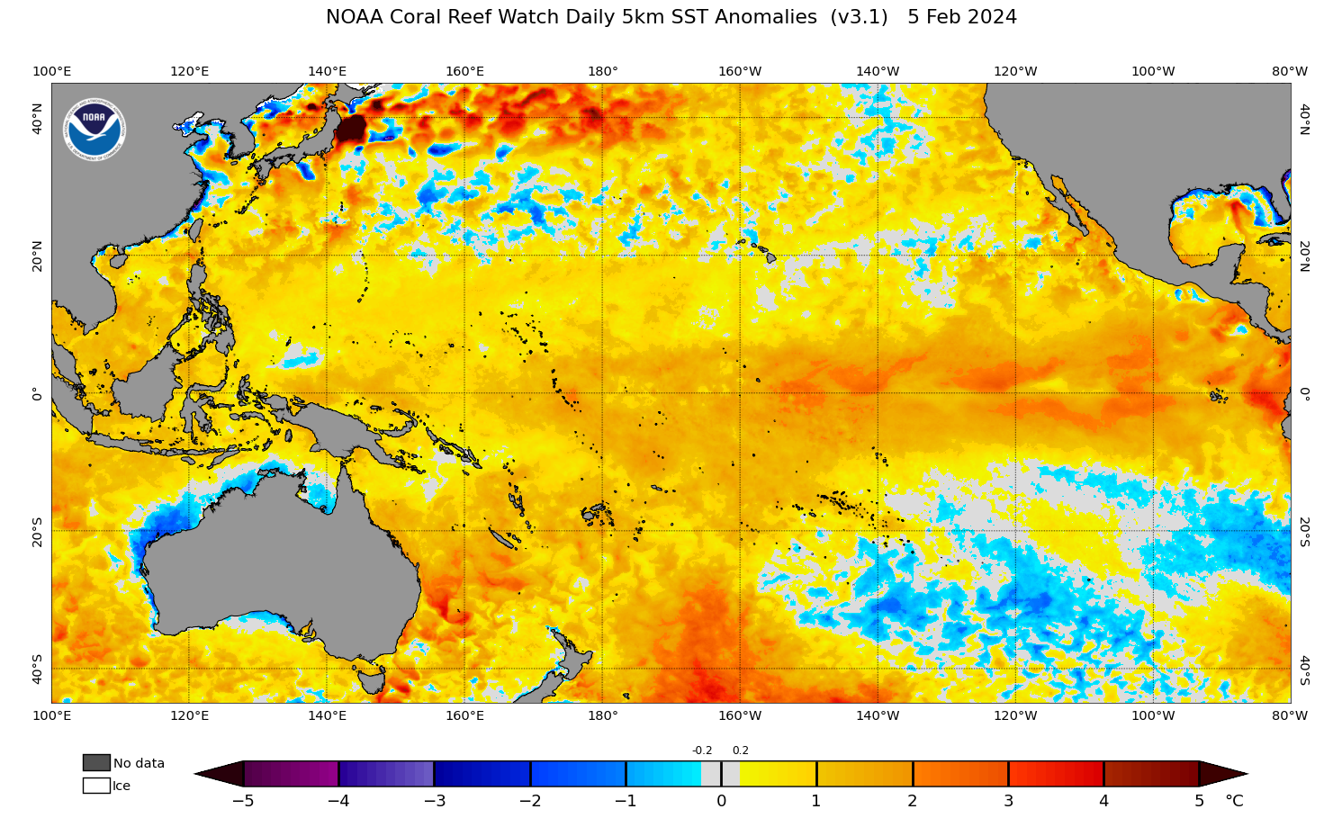
The oceans off the NSW and Qld coast are extremely warm and theoretically could provide enough energy to bring a tropical cyclone into NSW waters.
The map below shows that the temperatures off the Coffs Coast and north are currently above 26.5 °C, which is 2-3°C above average for this time of year.
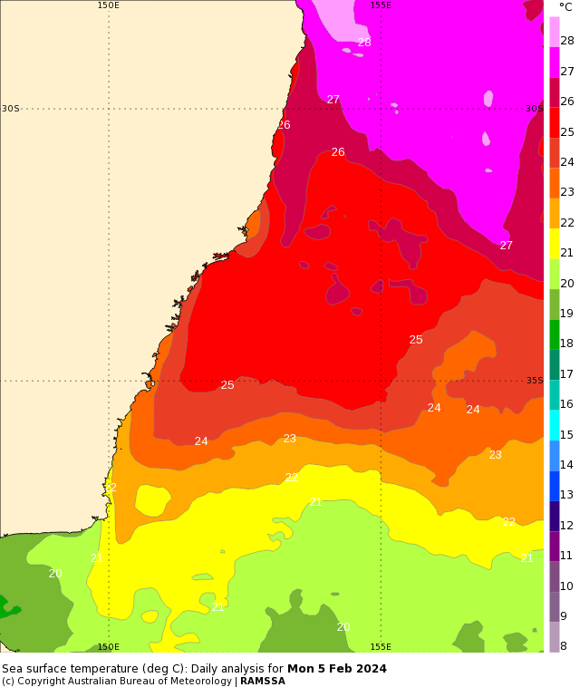
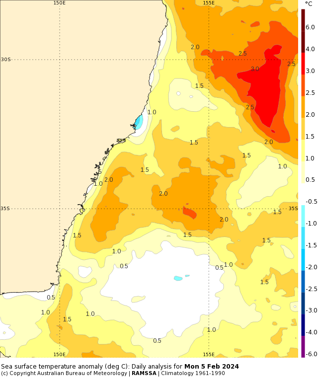
Image: Sea surface temperature daily analysis (top) and sea surface temperature anomaly (bottom) on Monday, February 5, Source: Bureau of Meteorology.
This warmth in the Northern Tasman Sea is not a localised phenomenon, with earth’s oceans having their warmest start to a year on record under the influence of El Niño and climate change.
Last year was the warmest year on record for Earth’s global oceans, with sea surface temperatures running at record high levels from mid-March until the end of the year. This unprecedented global ocean heat was caused in part by the warming effects of climate change and El Niño.
So, are the seas off northern NSW warm enough to support a cyclone?
Tropical cyclones are low pressure systems that form in ‘favourable’ atmospheric conditions and over warm oceans. Warm oceans are their source of energy, which means if they move over land or into cooler waters, this starves them of their energy source and causes them to dissipate.
According to The University of Western Australia, “ocean temperatures of at least 26.5 °C, from the surface down to 50 m deep, are needed to provide sufficient energy to [a tropical] disturbance to turn it into a tropical cyclone. Heat energy from warm water helps keep circulating winds moving”
Current observations off southeastern Qld and northeastern NSW coast show that the ocean temperature at 50 metres below the surface was 26.5°C on Monday, February 5.
This is exceptional because these temperatures at and below the surface are warm enough to support tropical cyclone development in these regions.
The oceans are expected to continue to warm over the coming months, as peak ocean temperatures typically occur in March or April. This is later than our ‘summer’ because large water bodies such as the ocean take much longer to warm up than the land.
It is important to point out that weather forecast models do not currently predict any tropical cyclone activity off the northeast coast of NSW in the coming one to two weeks.
Have tropical cyclones impacted NSW before?
Tropical cyclones and their effects have been felt as far south as Perth and far northeastern NSW in the past.
The map below shows the tracks of all cyclones in the number of tropical cyclones through the Australian region and waters between 1970 and 2006.
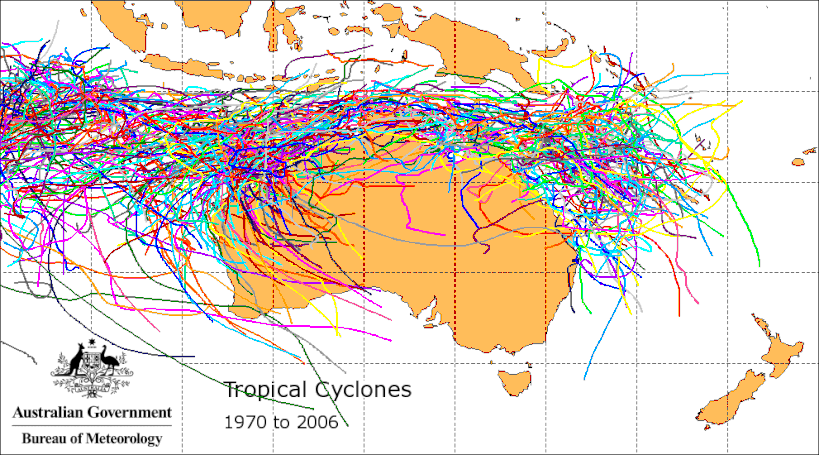
Image: the number of tropical cyclones through the Australian region and waters between 1970 and 2006, Source: BOM
There are a few examples of tropical cyclones or ex-tropical cyclones making their way down south to NSW, but mostly as ex-tropical cyclones;
- Tropical Cyclone Nancy formed in 1990 and was a category one cyclone off the coast of Brisbane causing significant flooding in the region. It then weakened into an ex-tropical cyclone as it moved south into NSW waters.
- Tropical Cyclone Oswald formed in 2013 in the Gulf of Carpentaria and weakened as it crossed the Qld coast. Ex-Tropical Cyclone Oswald tracked south into NSW, causing major flooding in northeastern NSW before moving as far south as Sydney.
- A recent example is Ex-Tropical Cyclone Kirrily that moved into NSW in February 2024, causing heavy rainfall and flooding in western NSW.
As you can see the chance of a cyclone moving into NSW is very rare, but ex-tropical cyclones occur more frequently.
The abnormally warm waters off the NSW and Qld coast have also brought record breaking humidity to NSW in recent weeks, with Sydney recording its muggiest day on record. The evaporated moisture from a tongue of abnormally warm water flowing near the NSW coastline was carried into the Sydney Basin by onshore winds.
This week, moisture laden air from the warm Tasman will feed into a coastal trough in NSW, bringing heavy rainfall in short periods of time in the next 72 hours. For more information on our cyclone services and briefings, please contact us at apac.sales@dtn.com.


