Prosper in a dynamic world
Search

Rain returning to the Pilbara


Rain and a few storms are on their way to the Pilbara as the official start to the wet season looms for some.

A northwest cloudband is starting to develop over the Pilbara region as moisture is drawn in from tropical activity occurring near Indonesia.

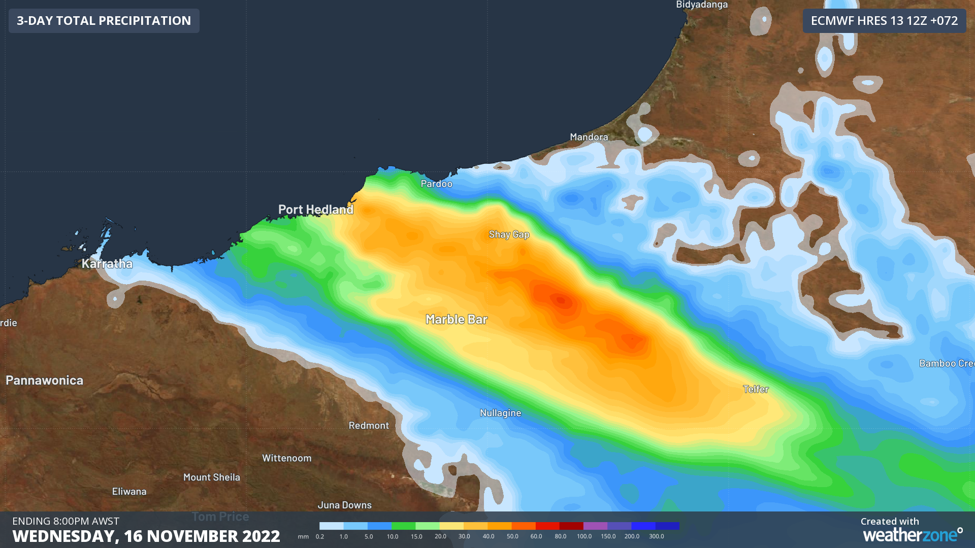
Over Tuesday afternoon and Wednesday, widespread falls of 10-30mm are expected over the eastern Pilbara, including Port Hedland and Marble Bar. Isolated falls of more than 50mm are also expected, most likely with thunderstorms.

20221114-nwp-pcp-ecmwf-hres-072_null_1920x1080 (1)

Image: Rainfall expected over the next few days over the Pilbara

The Pilbara is one of the few large regions left in northern Australia to have not started the wet season. The wet season onset is officially defined as when a location receives more than 50mm accumulated since September 1st.

So far this season, most of the Pilbara is well below the 50mm threshold. Port Hedland has collected 9mm, Karratha 12mm and Marble Bar has had 25mm. While it is normal for this region not to collect too much until the final weeks of the year, the rest of northern Australia has reached their onset much earlier than normal.

20221114-WetSeasonEarly

Image: Days difference from average onset date of the wet seasons. All coloured regions have received more than 50mm 

All the green shaded regions in the above map are locations that have started the wet season earlier than normal. That covers basically all the Kimberley, the Top End and throughout Queensland. The only area that have been late so far is the southern Gulf of Carpentaria.

This rain comes at the tail-end of this year’s negative Indian Ocean Dipole (IOD) that has brought record-breaking rain to the southeast over winter and spring. While oceans have cooled off the northwest shelf, the atmosphere is still reminiscent of a negative IOD. So, rainbands like this one are a higher-than-normal chance for the next few weeks while it lingers.

DTN APAC provides detailed forecasts and lightning detection so that your personnel and assets can be as prepared for whatever weather comes your way. To find out more, please email us at apac.sales@dtn.com.

Latest news

Satisfy your weather obsession with these news headlines from around the nation, and the world.

How does DTN help businesses monitor bushfire induced pyrocumulonimbus thunderstorms that ignite more fires?

Intense heat from bushfires during elevated fire danger days can trigger fire-induced pyrocumulonimbus thunderstorms that ignite additional fires. In early January 2026, an extreme heatwave sweeping over southeastern Australia brought catastrophic fire danger to Victoria. Intensely hot bush and grass fires spread erratically and quickly in hot, dry and gusty winds, with pyrocumulonimbus generating lightning, […]

Active seas to the north and east of Australia disrupting port and maritime operations

Seas to the north and east of Australia are experiencing periods of increased activity this week, leading to disruptions to port, maritime and offshore operations. Intense and hazardous Tasman Sea Ocean conditions across NSW’s South Coast rapidly deteriorated last Friday as a deep feed of easterly winds whipped up large and dangerous seas. The Batemans […]

Transport, emergency and energy industries flooded across Greater Sydney with weekend deluges

Transport, emergency, energy and port industries in eastern NSW and Sydney were impacted by significant flash flooding with intense and heavy rainfall this weekend. Rainfall rates between 80 and 140mm in one to three hours were registered across parts of Sydney’s Northern Beaches and Central Coast on Saturday afternoon and evening. In some areas, these […]

DTN Dangerous Thunderstorm Alerts in action with severe thunderstorms disrupting Perth industries

Severe thunderstorms impacted southwest WA and the Perth region on Sunday, December 14, 2025, triggering Dangerous Thunderstorm Alerts (DTA) by DTN for industries and businesses in the region. DTN operates Dangerous Thunderstorm Alerts (DTA) which alert businesses and industries to thunderstorms based on intensity and movement. These alerts provide advanced notice of thunderstorms moving into […]