
The north Australian build up period is in motion with a broad trough drawing intense heatwave conditions and triggering widespread thunderstorms across Australian mining areas.
Intense thunderstorms have lit up the north Australian skies over the past week as a broad horseshoe shaped low pressure trough extended across the country. DTN APAC’s Total Lightning Network (TLN) detected over 4 million lightning strikes across Queensland, the Northern Territory and northern Western Australia over the past week.
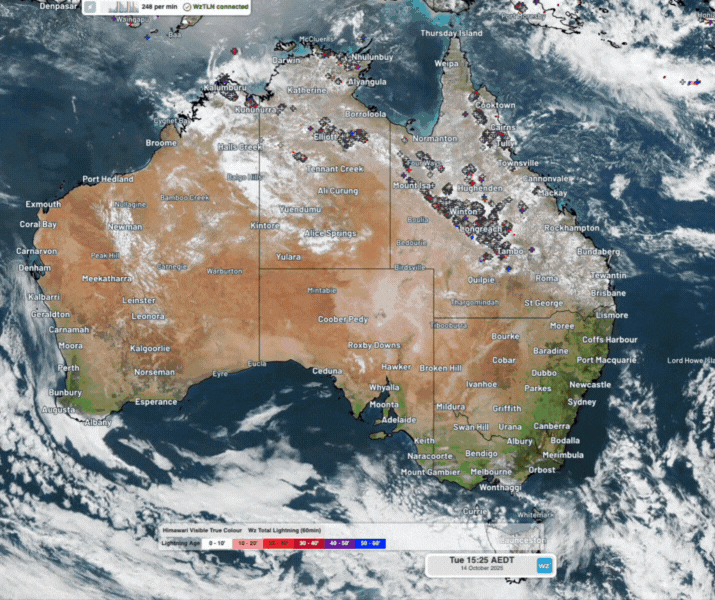
Image: Intense thunderstorm activity across Australia’s north and west on Tuesday and Wednesday, October 14 and 15, 2025, as seen on the DTN APAC Stormtracker Dashboard.
Hazardous weather impacting northern Australian mining areas
Heavy rainfall and localised flooding
After months of little to no rainfall throughout the dry season, this past week’s intense thunderstorm activity brought healthy rainfall to parched areas of northern Australia.
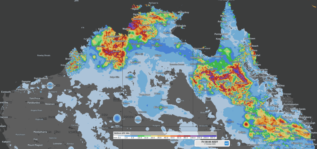
Image: DTN Quantitative Precipitation Estimates (QPE) of rainfall across northern Australia in the 7-days leading to Friday, October 17, 2025.
Intense thunderstorm rainfall over short periods of time increases the risk of flash flooding. For example, in the 24 hours to 9am on Sunday last weekend, thunderstorms over the Northern Territory brought the wettest October day in:
- 15 years for Alice Springs (17mm) and Jabiru Ap (57mm)
- 5 years for Borroloola (17mm) and Rabbit Flat (14mm)
- 4 years for McArthur River (18mm)
For many locations, like McArthur River, this rainfall marked the first drop of rain since the end of last wet season, 4-6 months ago.
High risk to exposed mining operations with over 4 million lightning strikes across northern Australia
Over 4 million lightning strikes have been recorded by DTN’s TLN over the past week across northern Australia. Lightning brings a serious risk of injuries and death to outdoor workers, significant damages to assets and vehicles, and general disruptions to operations.
The DTN Total Lightning Network is a key consideration across many mining operations. If your business or supply chain operates out in the open or in the air, your company could be at risk.
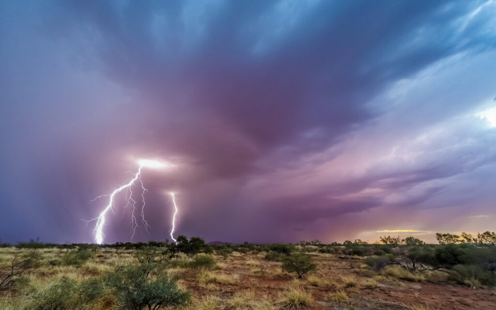
Image: Thunderstorms across broad open outdoor areas like the Pilbara require ample warning with few places to take safe shelter. Source: iStock / Darren Creighton
Visualise approaching storms as our customisable GIS system, Stormtracker, plots strike data across your site and infrastructure. This enables enhanced understanding of the potential risk inherent in each severe weather system and how storms produce hazardous conditions. Integrated satellite technology improves tracking accuracy, while real-time weather forecasts provide deeper insights into developing thunderstorm activity and potential disruptions.
Personal push notifications give users real-time severe weather and lightning alerts, based on their phone’s GPS position, enhancing their awareness of personal risk. Users can see lightning as it happens and track associated precipitation, ensuring more informed decision-making.
Lightning strike history is archived for over five years, enabling you to extract the reportable data required for risk assessments or insurance claims, with advanced calculation tools ensuring precise analysis.
Fires sparked by dry lightning
Very dry moisture levels across soil and vegetation in the region following the dry season, combined with the increasing risk of thunderstorms, greatly heightens the risk of dry lightning igniting fires.
High-based thunderstorms moving over central Western Australia on Tuesday evening brought intense lightning activity with little rainfall reaching the ground.
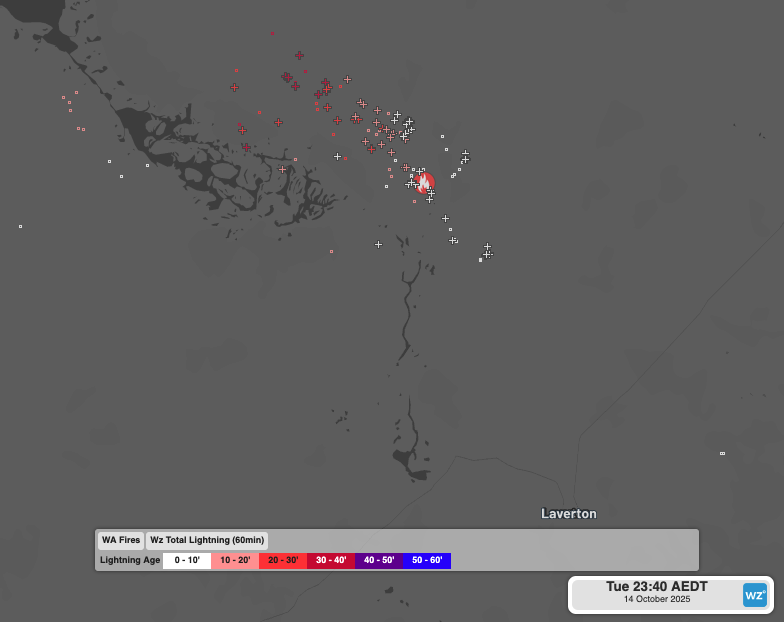
Image: Lightning strikes detected near a reported fire by WA fire services north of Laverton on Tuesday evening, October 14, 2025.
Satellite imagery on the following day shows a smoke plume dispersing from the active fire north of Laverton, likely triggered by dry lightning the previous night.
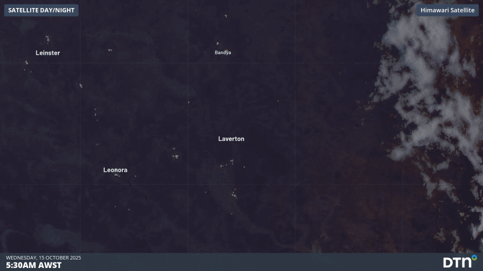
Image: Satellite imagery around Laverton, WA on Wednesday, October 15, 2025.
45°C heat and Severe-to-Extreme Heatwave conditions
The horseshoe trough extending through eastern, northern and western Australia is also drawing intense heat into mining areas. Temperatures exceeding 40°C have been recorded across the past week, with indications central Australia could reach 45°C this weekend or early next week.
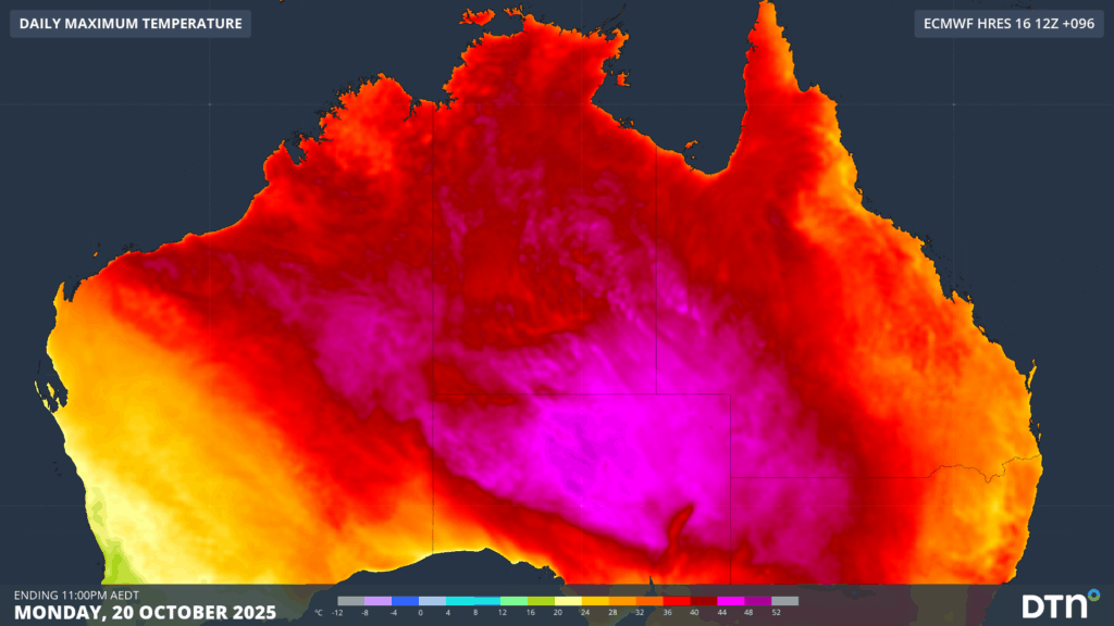
Image: Maximum temperature forecast for Monday, October 20, 2025, showing temperatures in the mid-40s across central parts of Australia.
These persistent hot temperatures are driving Severe-to-Extreme Heatwave conditions over parts of the Northern Territory (including Darwin), Western Australia and South Australia.
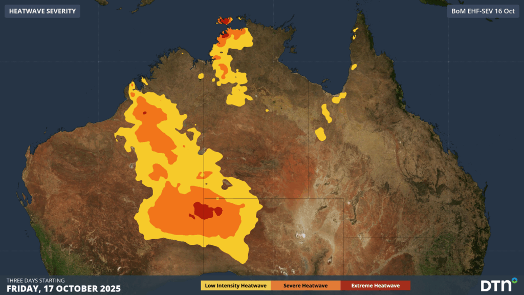
Image: Severe-to-Extreme Heatwave conditions forecast between Friday and Sunday, October 17-19, 2025.
How DTN’s remote sensing and now-casting solution are helping fill the gaps in traditional radar coverage across remote mining, transport and agricultural areas during the build-up season
Australia is a vast country with densely populated coastal areas across the south and east, and millions of square kilometres of sparsely populated and rich in resources elsewhere. Typical radar coverage extends to a radius of about 200km, however mountains, trees and towers can restrict this optimal coverage range. Even with over 60 radar sites operating across Australia, vast expanses of the outback and WA remain outside of this traditional radar coverage, as seen in the left image below.
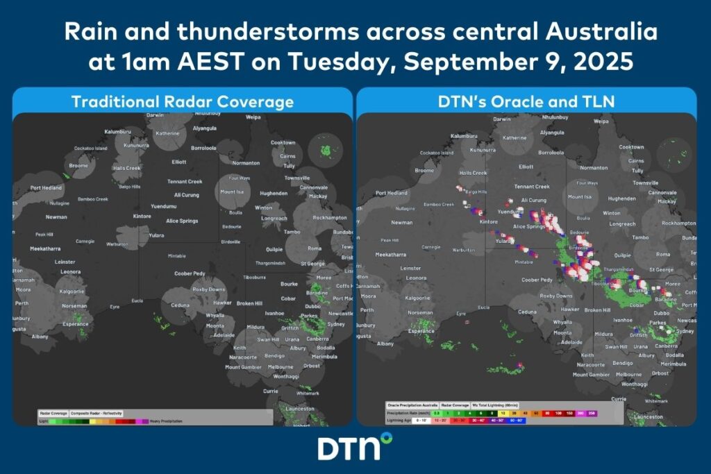
Image: Comparison of traditional radar coverage and detected rainfall (left), and DTN’s Oracle and TLN (right), across Australia at 1am AEST on Tuesday, September 9, 2025.
The image on the right shows DTN’s Oracle rainfall and Total Lightning Network detecting a vast area of rain and thunderstorms that would have been missed by traditional detection methods.
DTN Oracle
High-Resolution Modelling
Oracle is a satellite-derived, gridded nowcasting system. It forecasts out to 3 hours at a 1-2km resolution, and rapid updates every 5 minutes. With this enhanced forecasting detail, Oracle has the upper hand over 9-12km resolution models when capturing temperature, lightning, cloud cover, wind and rainfall. This ensures that no matter where you are in Australia, you will have access to precision nowcasting and forecasting that can rapidly inform your critical business decisions.
Greater Situational Awareness
Working in conjunction with DTN APAC’s Stormtracker GIS system, Oracle provides full situational awareness of any severe weather event that presents risk to your business. Short-term forecasting and severe weather alerts enable you to foresee the intensity and duration of events, so you can prioritise the safety and preparation of your staff and assets.
Whatever the weather, we provide the insights to help keep you and your team safe, productive and profitable.
DTN Total Lightning Network
Our Total Lightning Network is the intelligent lightning solution that goes above and beyond to alert lightning and increase your lead time before the storm hits.
We utilise a vast global sensor network, created with our partner Earth Networks. Over 1200 sensors in 40+ countries provide a worldwide view of both intra-cloud (IC) and cloud-to-ground (CG) lightning strikes, enabling businesses to plan and respond with the most precise insight available. Our system can detect and calculate strike locations with incredible accuracy, offering real-time lightning mapping for a comprehensive view of storm activity.
Offering unsurpassed accuracy, with real-time sensing to <200m, we integrate with your existing systems to keep your enterprise operating within your defined severe weather thresholds. Our technology also helps monitor radiation from electrical discharges and ensures every lightning flash is accounted for.
Leave nothing to chance. Be confident working outdoors with the most sophisticated lightning alerting system, delivering intelligence to any device across your business network. Whether you need a personal lightning alerting tool for individual safety or enterprise-wide monitoring, our solution is designed to emit timely alerts and protect your operations.
Learn more about our large range of industry leading products and services or email us at sales.apac@dtn.com


