
An extremely wet week is on the cards for northern Australia, with frequent thunderstorm activity and heavy rainfall likely impacting mining operations in the country’s north.
The soggy week is being partially caused by the Madden Julian Oscillation (MJO) which is currently over the Indian Ocean and nearing Australia. Models suggest that the MJO may linger in the region until at least Christmas.
The MJO refers to a pulse of increased tropical cloud, rainfall and thunderstorm activity that moves from west to east near the equator once every 30 to 60 days. When it’s near the Australian region it typically enhances rainfall and thunderstorm activity and increases the risk of tropical cyclone development.
The MJO will be in phase three, four and five during the next three weeks, which you can see in the maps below enhances rainfall across parts of Australia.
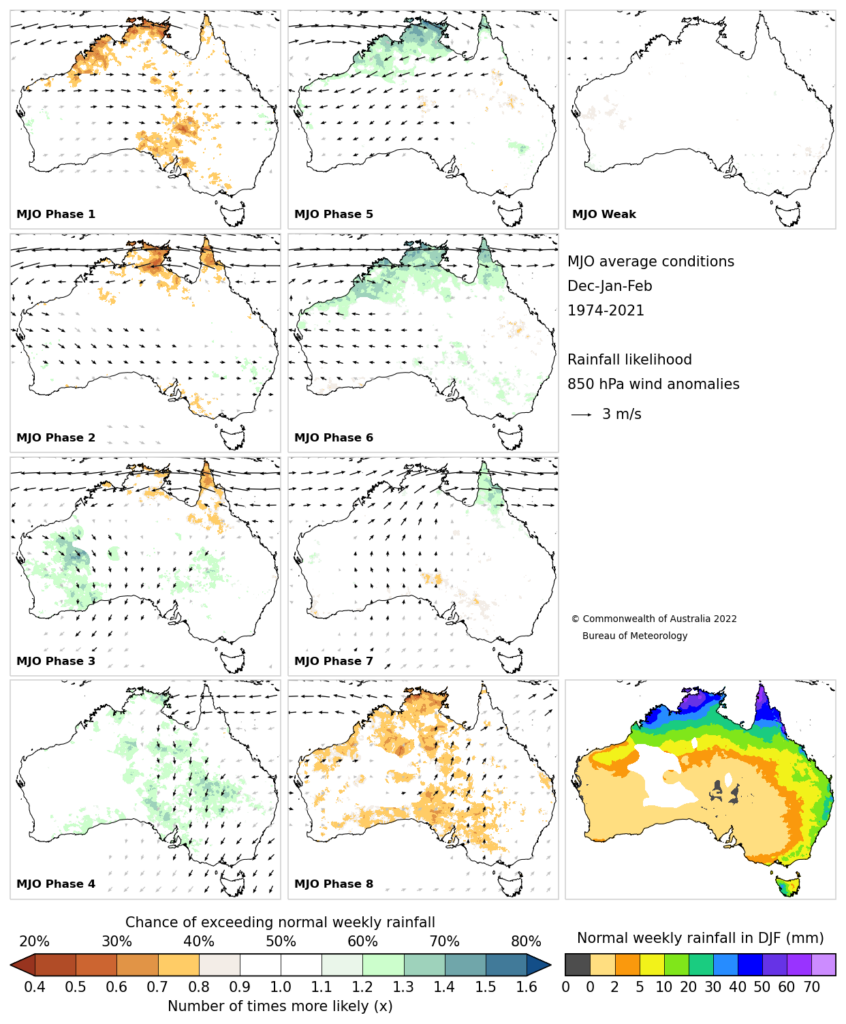
Image: Madden Julian Oscillation phases and the chance of exceeding normal weekly rainfall, with phase three four and five increasing rainfall over parts of Australia. Source BOM
The MJO’s location over the Indian Ocean may hep a tropical low near the Cocos (Keeling) Islands develop into a tropical cyclone in the coming days. This low has the potential to become the first named tropical cyclone of Australia’s 2024-25 cyclone season. There is potential for the MJO to bring on the monsoon onset with it during the opening week of December, which would enhance the rainfall further.
In addition to the MJO, a Kelvin wave and equatorial Rossby wave will both be located to the north of Australia during late November and early December enhancing rainfall further.
Equatorial Rossby waves are also known as planetary waves which move along the equator east to west and can enhance tropical activity when near Australia. This is because it usually causes a pair of twin low pressure systems either side of the equator which causes air to spin and rise.
Equatorial Kelvin waves balance Coriolis Force in the northern hemisphere against its southern hemisphere counterpart and propagate eastward around the equator. When it’s in the Australian region it can enhance rainfall, storm activity.
The three equatorial waves coinciding during the last week of November, will bring large rainfall totals to northern Australia in the coming week. Widespread weekly totals of 80 to 100 millimetres are forecast across northern parts of WA, the NT and Qld, while some isolated areas could see 150 to 200 millimetres particularly in thunderstorm activity.

Image: Accumulated rainfall for the next eight days leading up to 5am AEDT on Thursday, December 5, according to Access-G
The largest daily totals are forecast between Thursday and Monday next week, with the possibility of 50 to 80 millimeters falling in thunderstorms. Darwin airport already has copped 49mm in the hour leading up to 12:30pm local on Tuesday, November 26.
Heavy rainfall such as this at a mine site or associated railways or roads can shut down operations for days, costing the business economically.
DTN delivers a Rainfall Risk System to equip you with detailed situational awareness.
Advanced Geofence Technology
You can measure rainfall and access rapid-update forecasting across multiple sections of your site or assets with our geofence alerting system. The technology creates hundreds of virtual ‘weather stations’ for each chosen catchment, enabling precise determination of both rainfall intensity and accumulation.
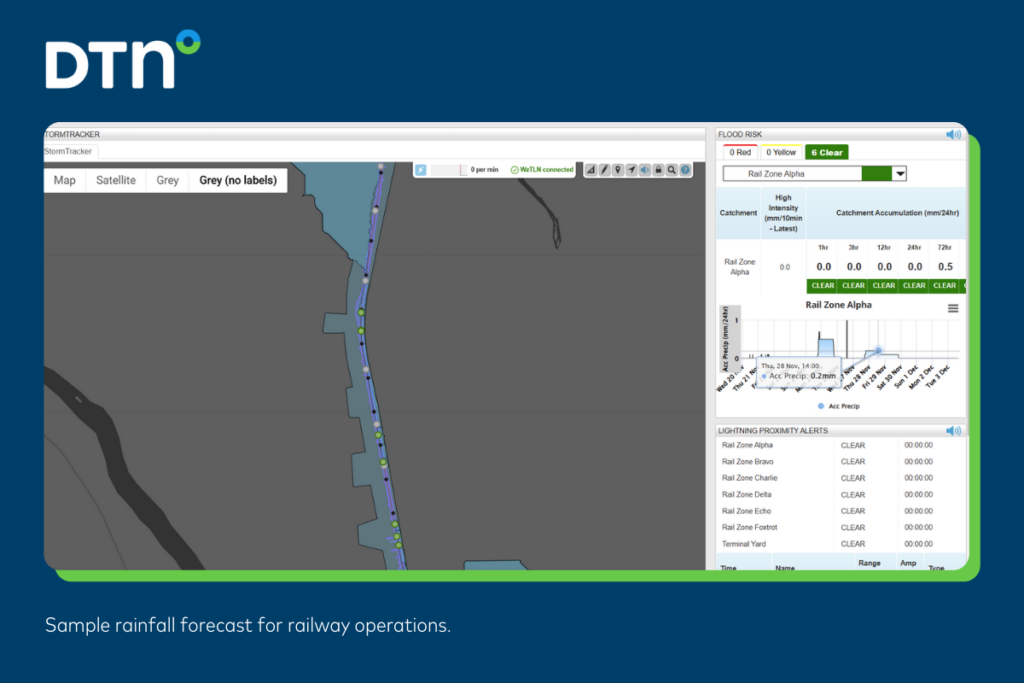
Image: Rainfall forecast for a client’s railway
Real-time Flood Risk and Alerts
Real-time Flood Risk and Alerts Real-time rainfall is measured across each catchment in relation to their defined thresholds. Alerts are raised when thresholds for any section are approaching or have been breached, giving you targeted visibility of flood risk to inform your operational response.
Driven by Precise High-resolution Modelling
Oracle is Weatherzone’s satellite-derived gridded nowcasting system, forecasting at a 1-2km resolution and updating every five minutes. This capacity gives Oracle the upper hand in capturing temperature, lightning, cloud cover, wind, and rainfall for your exact location, no matter how remote.
For more information please visit our website or email us at sales.apac@dtn.com.


