Prosper in a dynamic world
Search

Geraldton’s hottest September day in more than a century of records

It was Geraldton’s hottest September day in more than a century. Temperature records are being broken in WA today as a searing air mass spreads across the state’s north and west.

A high pressure system centred over the Great Australian Bight is causing a pool of hot air to intensify over northwestern Australia, with temperatures soaring 15ºC above average in some areas today.

Geraldton's hottest September day. century of records

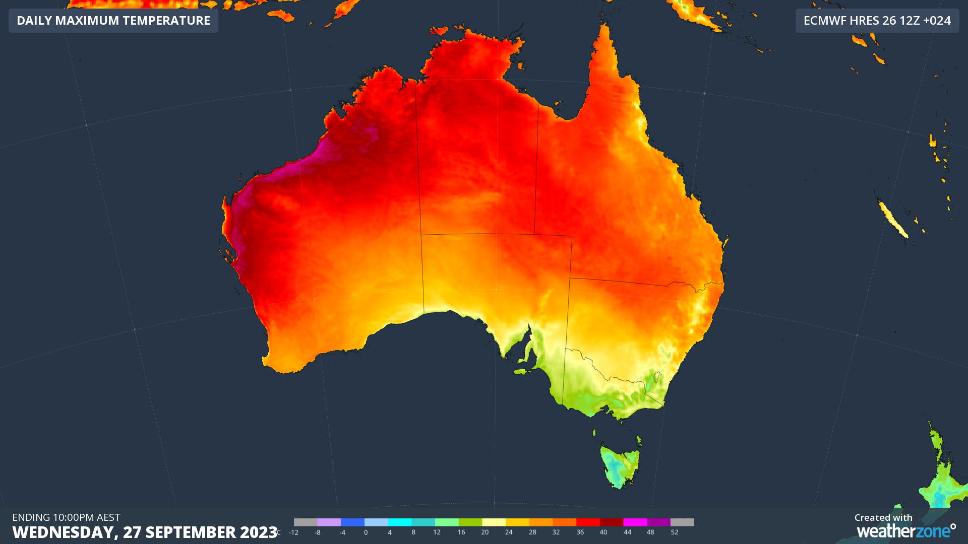
Image: Modelled maximum temperatures on Wednesday, September 27, according to the ECMWF-HRES model.

As of midday on Wednesday, September 27, temperatures in the state’s north had already reached as high as 41.4ºC at Mardie.

Geraldton’s hottest September had a running maximum of 38.0ºC by midday which was its highest September temperature on record, easily beating the old record of 36.1ºC from 2010. This is an impressive record, with data at Geraldton dating back to 1907.

Perth had only reached 30.3ºC by midday, although the city is forecast to reach around 34ºC in the afternoon. This could challenge the city’s September record of 34.2ºC from 2014.

Other records may fall in WA during the afternoon. This story will be updated with more information later in the day. For more information on Weatherzone’s extreme temperature forecasts, please contact us at apac.sales@dtn.com.

Latest news

Satisfy your weather obsession with these news headlines from around the nation, and the world.

How does DTN help businesses monitor bushfire induced pyrocumulonimbus thunderstorms that ignite more fires?

Intense heat from bushfires during elevated fire danger days can trigger fire-induced pyrocumulonimbus thunderstorms that ignite additional fires. In early January 2026, an extreme heatwave sweeping over southeastern Australia brought catastrophic fire danger to Victoria. Intensely hot bush and grass fires spread erratically and quickly in hot, dry and gusty winds, with pyrocumulonimbus generating lightning, […]

Active seas to the north and east of Australia disrupting port and maritime operations

Seas to the north and east of Australia are experiencing periods of increased activity this week, leading to disruptions to port, maritime and offshore operations. Intense and hazardous Tasman Sea Ocean conditions across NSW’s South Coast rapidly deteriorated last Friday as a deep feed of easterly winds whipped up large and dangerous seas. The Batemans […]

Transport, emergency and energy industries flooded across Greater Sydney with weekend deluges

Transport, emergency, energy and port industries in eastern NSW and Sydney were impacted by significant flash flooding with intense and heavy rainfall this weekend. Rainfall rates between 80 and 140mm in one to three hours were registered across parts of Sydney’s Northern Beaches and Central Coast on Saturday afternoon and evening. In some areas, these […]

DTN Dangerous Thunderstorm Alerts in action with severe thunderstorms disrupting Perth industries

Severe thunderstorms impacted southwest WA and the Perth region on Sunday, December 14, 2025, triggering Dangerous Thunderstorm Alerts (DTA) by DTN for industries and businesses in the region. DTN operates Dangerous Thunderstorm Alerts (DTA) which alert businesses and industries to thunderstorms based on intensity and movement. These alerts provide advanced notice of thunderstorms moving into […]