Prosper in a dynamic world
Search

Four weeks above 43ºC in Marble Bar

Marble Bar is on track to register four straight weeks of daily temperatures above 43ºC, possibly setting a new extreme heat record in a town already world famous for its relentless summer temperatures.

Marble Bar made international headlines in the 1920s when it registered 160 consecutive days above 37.7ºC (100ºF) in 1923-24, a world record that still stands to this day.

The outback WA town is now having another incredible run of heat that could see once again re-write the record books exactly 100 years later.

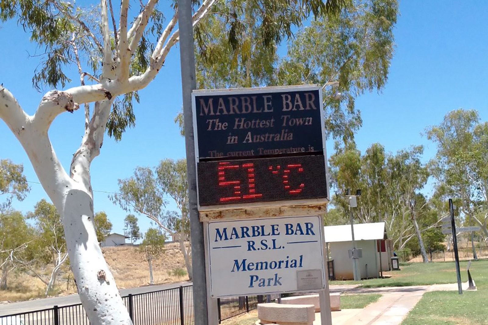
Image: An unofficial thermometer in Marble Bar registering a temperature of 51ºC on December 31, 2023. Source: AAP Image/Supplied by Wendy McWhirter Brooks

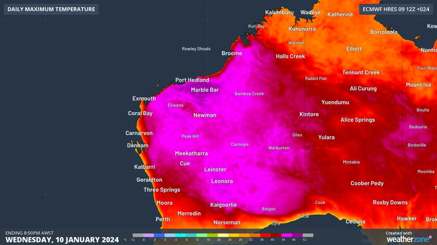
Marble Bar has reached or exceeded 43ºC (109ºF) every day between December 19, 2023 and January 10, 2024. This 23-day run of maximum temperatures at or above 43ºC is the equal 2nd longest such spell on record, matching similar heatwaves in 2021 and 2015-16, and beaten only by a 27-day stretch in 2005.

While Marble Bar is still a few days off the record, temperatures are forecast to reach 44 to 47ºC between now and Sunday, and 43ºC on Monday next week. If this run of days at or above 43ºC continues until Sunday, it will equal to current record. If it lasts until Monday, a new record will be set.

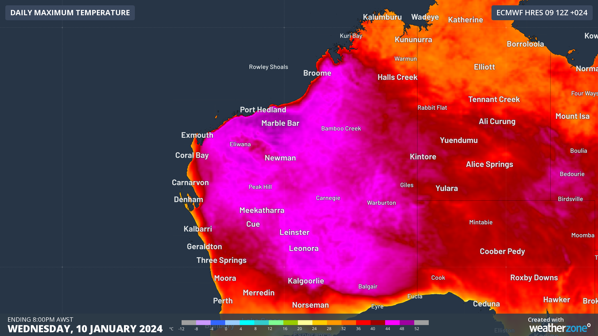
Image: Forecast maximum temperature on Wednesday, January 10, 2024, according to the ECMWF-HRES model.

The main reason Marble Bar has experienced such an intense run of heat in recent weeks has been the absence of the monsoon in northern Australia, which is associated with El Niño. While the monsoon trough is forecast to finally arrive over parts of northern Australia later this week, it will initially be too far east to bring any relief to Marble Bar.

So when will it cool down in Marble Bar? There are indications that a low pressure trough tapping into some tropical moisture may help keep the temperature under 43ºC around Tuesday next week. But by then, Marble Bar could have a new record to its name. For more information on Weatherzone’s temperature forecasts, please contact us at apac.sales@dtn.com.

Latest news

Satisfy your weather obsession with these news headlines from around the nation, and the world.

How does DTN help businesses monitor bushfire induced pyrocumulonimbus thunderstorms that ignite more fires?

Intense heat from bushfires during elevated fire danger days can trigger fire-induced pyrocumulonimbus thunderstorms that ignite additional fires. In early January 2026, an extreme heatwave sweeping over southeastern Australia brought catastrophic fire danger to Victoria. Intensely hot bush and grass fires spread erratically and quickly in hot, dry and gusty winds, with pyrocumulonimbus generating lightning, […]

Active seas to the north and east of Australia disrupting port and maritime operations

Seas to the north and east of Australia are experiencing periods of increased activity this week, leading to disruptions to port, maritime and offshore operations. Intense and hazardous Tasman Sea Ocean conditions across NSW’s South Coast rapidly deteriorated last Friday as a deep feed of easterly winds whipped up large and dangerous seas. The Batemans […]

Transport, emergency and energy industries flooded across Greater Sydney with weekend deluges

Transport, emergency, energy and port industries in eastern NSW and Sydney were impacted by significant flash flooding with intense and heavy rainfall this weekend. Rainfall rates between 80 and 140mm in one to three hours were registered across parts of Sydney’s Northern Beaches and Central Coast on Saturday afternoon and evening. In some areas, these […]

DTN Dangerous Thunderstorm Alerts in action with severe thunderstorms disrupting Perth industries

Severe thunderstorms impacted southwest WA and the Perth region on Sunday, December 14, 2025, triggering Dangerous Thunderstorm Alerts (DTA) by DTN for industries and businesses in the region. DTN operates Dangerous Thunderstorm Alerts (DTA) which alert businesses and industries to thunderstorms based on intensity and movement. These alerts provide advanced notice of thunderstorms moving into […]