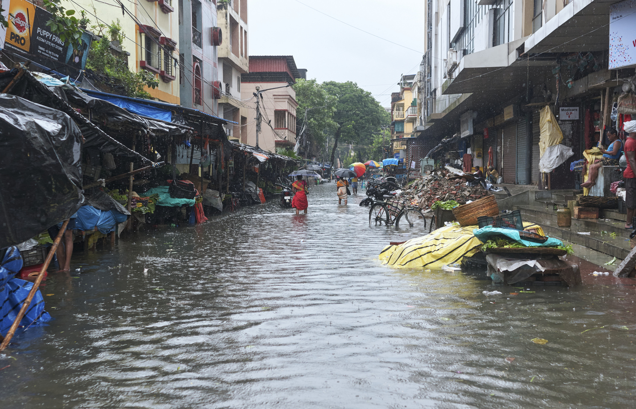
After months of intense heat, the Monsoon’s rains bring joy and prosperity to India, but its seasonal downpours can disrupt transport, mining, and energy industries.
As the Northern Hemisphere summer comes around, the Indian interior heats up significantly, leading to an area of low pressure over India’s north. Moist winds from the Indian Ocean, to the southwest of India, rush into the sub-continent to fill this void in the north. This stream of moist southwesterly winds is called the southwest Monsoon, which brings the relieving rainfall to the sweltering country.
When does the Monsoon arrive?
Typically, the Monsoon sweeps north over the Indian continent between late May and July – lasting till about September following the onset. The Monsoon first reaches the far southern state of Kerala, where it first encounters the Western Ghats. This insurmountable mountain range causes the moisture to precipitate heavily on the western side of the ranges, with little rainfall crossing over the mountains.
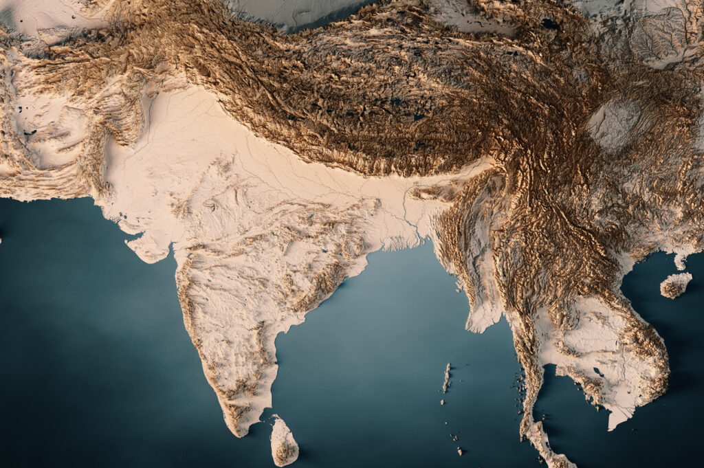
Image: India’s exaggerated topography with a large variation in height between the Himalayas and the rest of the Indian Continent. Source: iStock/ FrankRamspott
The Western Ghats split the Monsoon progression into two branches, the Arabian Sea branch travelling north along the west of the country, and the Bay of Bengal branch, which is forced to the east of the country. The eastern branch can pick up more moisture over the Bay of Bengal, moving into far eastern India as it collides with the Himalayas.
The Bay of Bengal branch swings around the Western Ghats delaying the monsoon arrival in the east of the country compared to the west. The image below shows the monsoon arrives over Kerala region early June, Odisha (formally known as Orissa) and Mumbai around the 10th to 15th of June and late June around the Delhi region.
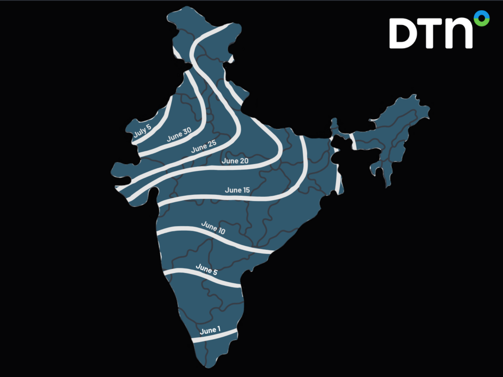
Image: The typical monsoon arrival date for Indian regions. Data: Indian Meteorological Department
However, there have been years where it hasn’t progressed as far north as the Delhi region, which are referred to as monsoon failures.
How much rain does the Monsoon bring?
The monsoon brings about 80% of India’s annual rainfall between June and September. India is a very large country and the amount of rainfall that each region sees during the monsoon can vary significantly. The wettest areas in India are generally the Western Ghats and the northeast of the country.
The image below shows that the Greater Mumbai, Odisha and Delhi regions receive significant rainfall when the monsoon is in the region, with very little rainfall falling during the other seven months of the year.
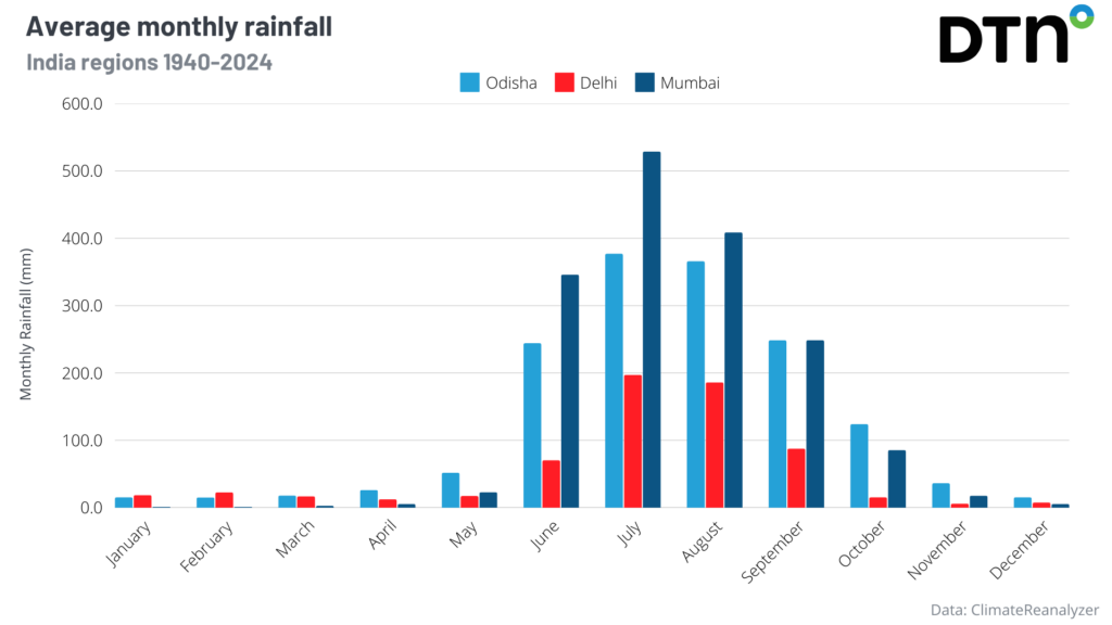
The highest average monthly rainfall for these regions occurs in July, with Mumbai observing the largest totals with 528.9mm, followed by Odisha with 377mm and Delhi 197.2mm.
You can also see in the graphs below that for each year between 1940 and 2024 the wet season rainfall makes up most of the yearly totals, showing the importance of forecasting the monsoon.
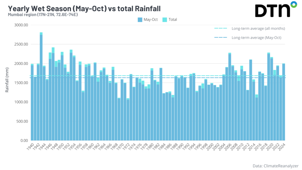
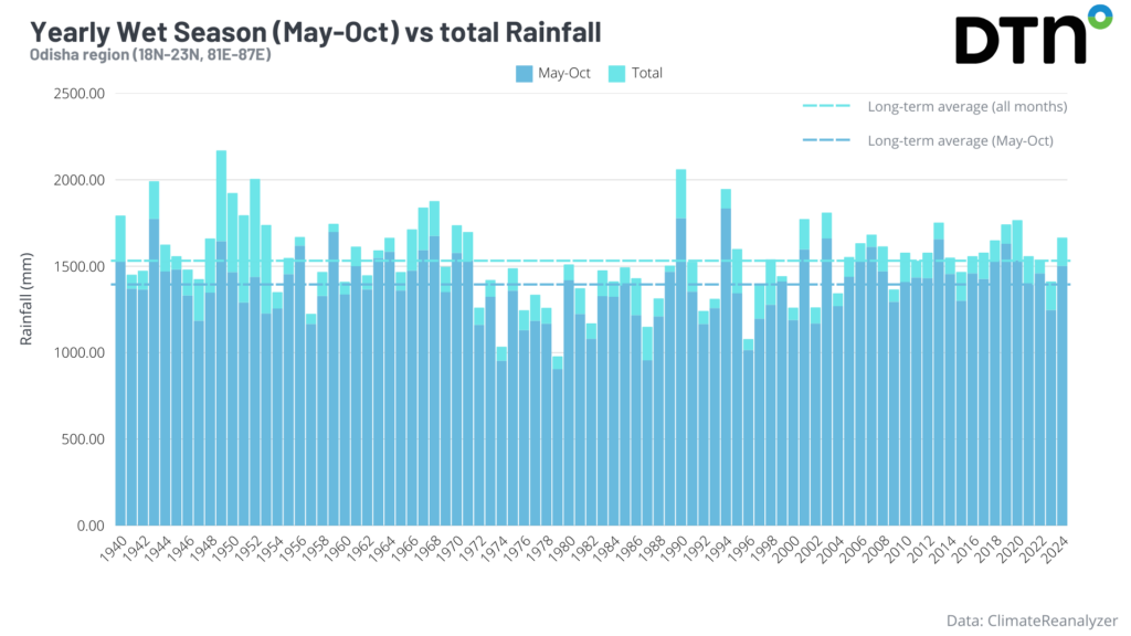
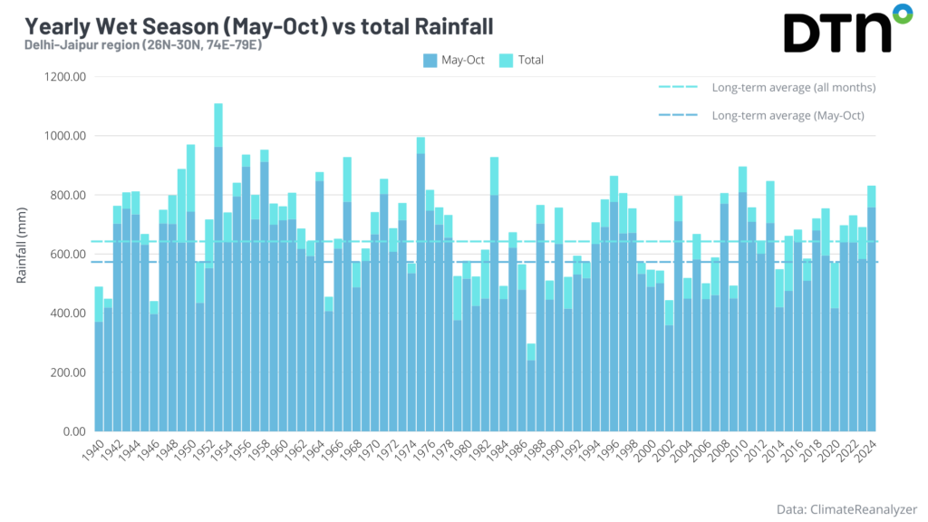
While there are wet years and drier years, the average monsoonal rainfall for Mumbai is around 1600mm, then Odisha with 1400mm and 590mm in the Delhi region. Delhi receives less rainfall than the regions further south because the monsoon arrives later in June and often dries out before reaching the region.
When will the Monsoon retreat?
As the Northern Hemisphere summer comes to an end, the northern Indian subcontinent cools and the pressure increases, leading to a reversal of the Southwest Monsoon (called the Northeast Monsoon). Cold and dry winds flow down the Himalayas into India – causing the retreat of the Monsoon during September and October.
The image below shows the monsoon retreats from the Delhi region in late September, Odisha (formally known as Orissa) and Mumbai between early to mid-October and Kerala in late October.
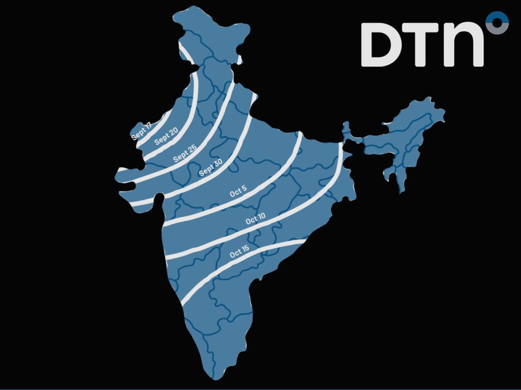
Image: The monsoon retreat date for Indian regions. Data: Indian Meteorological Department
How DTN APAC can help
Flood risk system
DTN’s flood risk system uses radar and geofencing to provide businesses with rainfall alerts and forecasts. The system can be customised to a business’s operations and industry.
The system scans rainfall intensity every 6 to 10 minutes and sends alerts and updated to business’s specific locations. It also uses geofencing technology to target alerts for specific sites and works with Opticast, a forecast system that predicts rainfall intensity and accumulation. We can also provide long-term rainfall forecasts up to six months in advance.
Benefits to businesses:
- Helps businesses plan ahead and reduce the impact on operations
- Provides real-time situational awareness
- Helps businesses maintain flood risk awareness
- Improves communications with local information and flood alerts
- Provides team-wide access to flood risk data
Tropical cyclone forecasting
DTN APAC, specialises in industry-leading forecast, alerting and threat analysis of tropical cyclones, offering you expert, customised solutions when the weather turns wild.
Providing rapid-update forecast information, we alert you to any low-pressure system gaining power within your region and, unlike other providers, can track its development out to 7 days. This gives you the time to prepare and safeguard your staff, sites and assets.
To find out more about large range of products and services contact us at sales.apac@dtn.com
Thumbnail image: iStock /Suprabhat Dutta


