Warnings for strong to gale force winds, hazardous surf and flooding are in place across eastern NSW and southeast Queensland as an East Coast Low develops.
A deepening coastal trough over southeast Queensland and northeast NSW has already brought widespread falls of 30 to 70mm over Sunday afternoon and Monday morning. Dunwich Airport, on North Stradbroke Island, Queensland, collected 103mm in the 24 hours to 9am.
Video: Satellite imagery showing a coastal trough across eastern Australia between Sunday, June 29, and Monday, June 30, 2025.
Explosive cyclogenesis to spawn East Coast Low
The coastal trough currently positioned off the NSW’s Northern Rivers will rapidly intensify through a process of explosive cyclogenesis.
This explosive process means that the central pressure of the system is expected to drop rapidly from about 1015 hPa around midday on Monday, to about 993 hPa 24 hours later on Tuesday. The drop of over 20 hPa in 24 hours classifies the system as a bombing low, exceeding the required 15 hPa drop at this latitude.
Video: forecast Mean Sea Level Pressure (MSLP) and 6-hour rainfall between Monday, June 30 and Sunday, July 6, 2025.
As mentioned in our previous article on what makes an East Coast Low, this rapid intensification comes as a result of a number of factors, including:
- Warm Sea Surface Temperatures (SST)
- Baroclinic instability (a large termperature difference in air masses)
- A blocking high pressure system
- An upper trough over the Great Dividing Range
Where will be most affected and when?
As the ECL develops over the coming 24 hours, moisture wrapping around the low will shift southwards.
As seen in the image below, most weather models focus the heaviest rainfall around the Mid North Coast and parts of the Hunter, with 150-200mm over a period of 24-36 hours to early Wednesday. Winds will also intensify overnight into Tuesday, most likely south of Coffs Harbour.
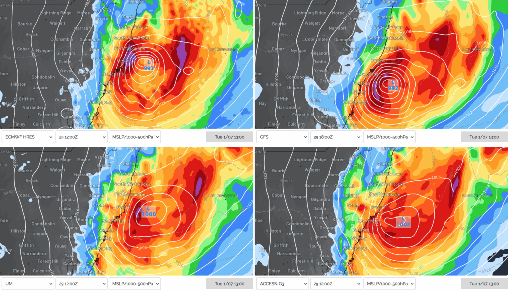
Image: MSLP and 24-hour rainfall accumulation at 1pm on Tuesday, July 1, 2025, according to ECMWF (top left), GFS (top right), UKMO (bottom left) and ACCESS-G (bottom right).
East Coast Low reaches peak intensity
From midday on Tuesday, extending into Wednesday, the ECL is expected to reach its peak intensity in close proximity to the coast with the central pressure expected to drop to around 980 to 985 hPa.
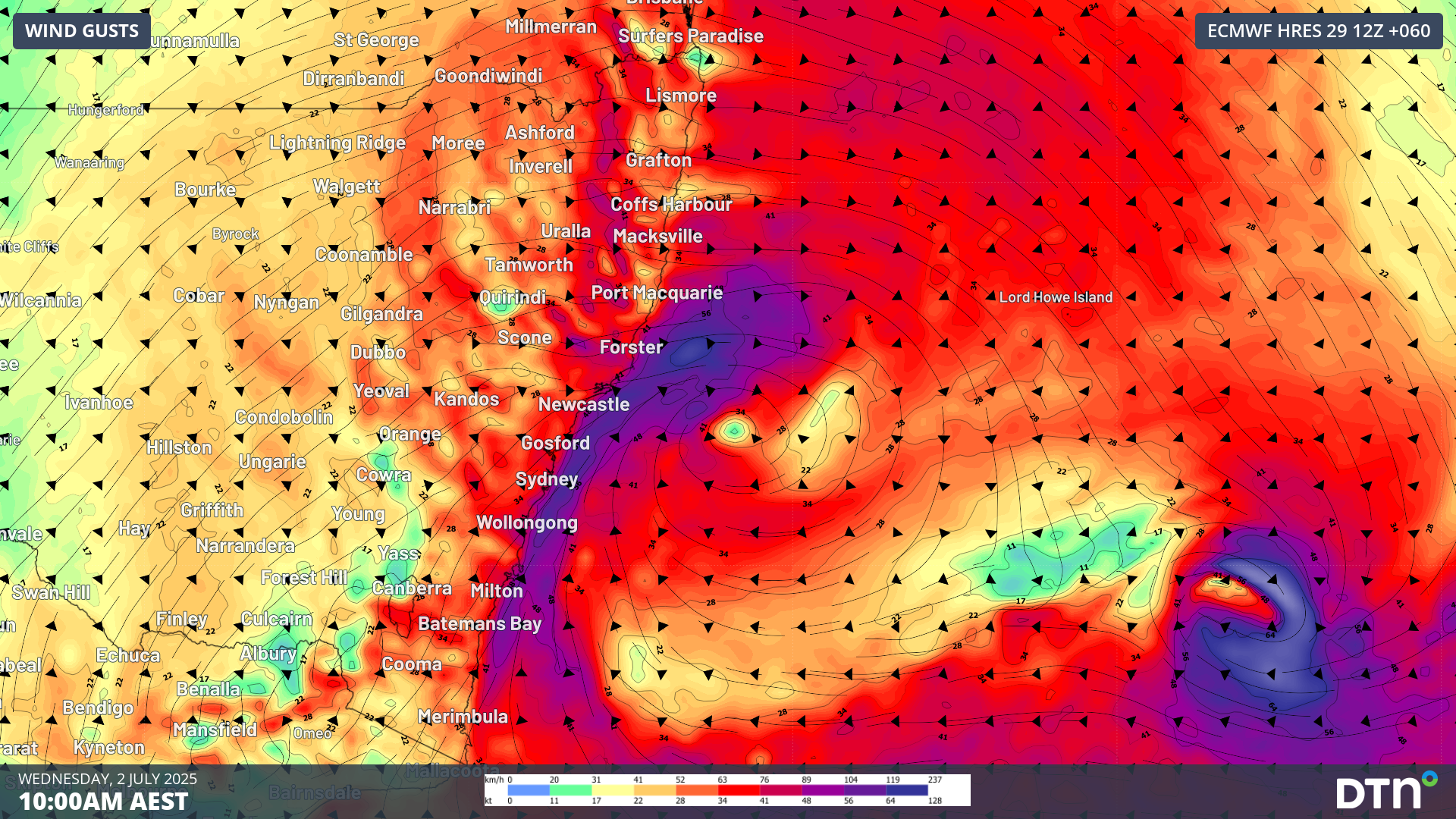
Much of coastal NSW between Batemans Bay and Port Macquarie is at risk of experiencing wind gusts exceeding 100km/h on Wednesday morning, with areas on and east of the Great Dividing Range also experiencing strong winds. The strong winds will combine with the heavy rainfall, helping bring down trees and other debris, leading to disruptions to transport and energy operators.

Image: Forecast 10 metre wind gusts at 10am on Wednesday, July 2, 2025.
Flooding rainfall reaches Sydney and Illawarra
Intense heavy rainfall will shift southwards into the Sydney and Illawarra regions from about midday on Tuesday, reaching its peak intensity overnight into Wednesday morning. Another burst of moisture and rainfall will sweep over southeastern NSW between Wednesday afternoon and Thursday morning as an arm of the ECL moves inland.
Across the coming 48-60 hours, widespread falls of 150-250mm are expected south of about Port Macquarie, with more intense deluges of 300-400mm possible across parts of the Illawarra and Shoalhaven regions between Monday and Thursday evening.
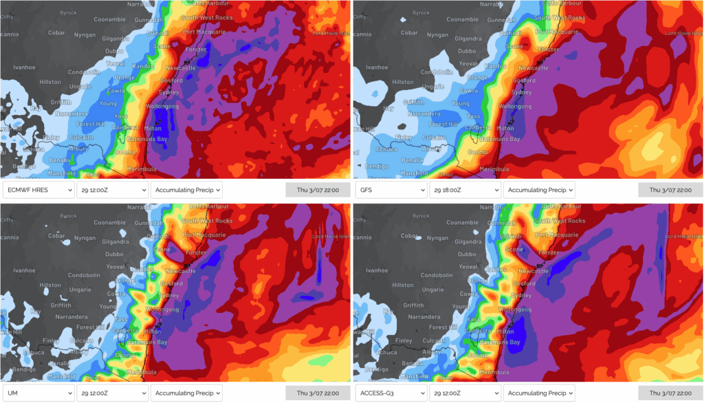
Image: Rainfall accumulations across NSW to 10pm on Thursday, July 3, 2025, according to ECMWF (top left), GFS (top right), UKMO (bottom left) and ACCESS-G (bottom right).
Powerful and hazardous surf
Along with the rain, the powerful winds wrapping around the ECL will generate large and hazardous surf, likely leading to significant erosion in some areas of coastal NSW.
Significant wave heights of 5 to 6 metres are expected across coasts between Seal Rocks and Batemans Bay, with large waves extending further south and north. Maximum wave heights of 11 to 13 metres are also expected over a similar region.
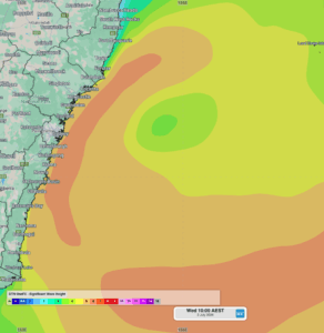
Image: OneFX forecast Significant Wave Heights at 10am on Wednesday, July 2, 2025.
Wave energy coming from the east will significantly enhance coastal erosion, especially across parts of the Central Coast, Sydney and Illawarra more exposed to the most of this energy. Fortunately, the high tides next week will only be moderate in height with the neap tide occurring later in the week.
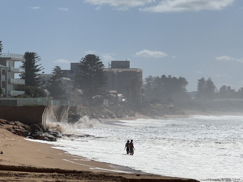
Image: Erosion prone beaches, like Narrabeen-Collaroy Beach, are in a vulnerable state ahead of this week’s swell. Source: Felix Levesque
When will the weather clear?
The East Coast Low is expected to move east further into the Tasman Sea on Thursday afternoon, with heavy rain and strong winds gradually easing as it does so. By late on Thursday, or early on Friday, most of the rain should be offshore, with winds abating as well. The swell is expected to remain large into Friday, but should ease significantly into the weekend.
How DTN APAC can support your business through East Coast Lows
From Transport to Utilities, and Ports to Offshore energy farms, our weather solutions can help your business across Australia and New South Wales plan ahead and make confidence decisions when severe weather impacts.
Stormtracker
Embedded in DTN APAC’s industry interfaces, the system gives you a time advantage when monitoring conditions developing over your infrastructure and location.
Stormtracker is our Global Information System (GIS) tracking tool, providing multiple weather layers and zoom controls overlaid on a map of your location and infrastructure. You can choose a snapshot or full screen view, depending on your requirements. The maps allow you to monitor all weather, and specifically any systems like East Coast Lows likely to cause risk for your business. You also have the capacity to observe:
- real time lightning and thunderstorm alerts
- localised lightning strike frequency
- official warnings for storm, cyclone, wind, flood and fire
- sentinel hotspot fires and fire agency current incidents
![]()
Image: the DTN APAC Stormtracker in action showing Radar, the Total Lightning Network, current warnings and rainfall observations to 9am across NSW on Monday, June 30, 2025.
Stormtracker’s radar imagery updates every 5 minutes, so you are always able to respond rapidly to changing conditions. You can customise alerting to notify you when your staff or infrastructure are under threat. With increased situational awareness, your ability to make informed decisions quickly is optimised.
DTN APAC’ experience and intelligence gives you a clear path through complex situations. Let us assist you, offering actionable insight when extreme weather poses risk to your business.
DTN APAC Risk Communicators
Our Risk Communicators work closely with you to analyse how weather impacts your operations and communicate potential risks. We can then support your risk management planning, and provide situational awareness and post-event reporting when extreme weather events hit hard.
DTN APAC, is a diverse team, with global forecasting, product development and analytics expertise. Couple this with extensive industry experience spanning Aviation to Energy, and we are primed to assist you in strengthening your operational strategies when responding to weather disruption.
We consult with you to understand the nuances of your operations and your existing procedures and policies. We can then assist in creating communication structures, safety strategies and procedures to mitigate the risks that may impact your workforce, assets and uptime.
Our Risk Communicators are working closely with industries and businesses likely to be affected by this week’s East Coast Low, in order to mitigate the risk of damaging and long lasting impacts. Our weather risk communicators deliver short- to long- term guidance from:
- hourly-event weather monitoring (assisting you when severe weather is about to hits and is likely to clear).
- week to month operational planning based on likely timing of increased rain or low pressure development.
- seasonal long term planning based on climate drivers and the likely trends across the coming months.
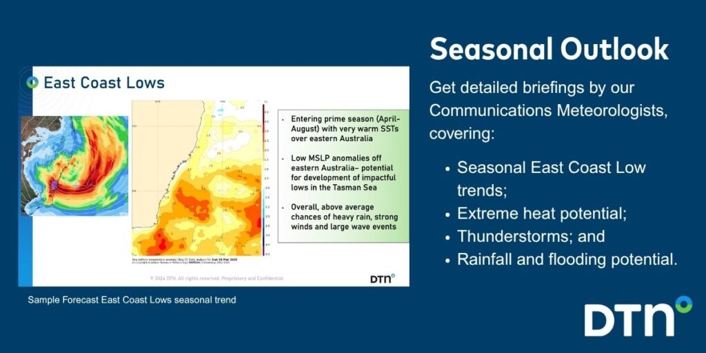
As seen below, long range forecasts provided by our weather risk communicators at the start of autumn signaled for increased activity in the Tasman Sea over the coming autumn and winter.
We deliver clear and comprehensive weather data that you can’t get anywhere else, personalised risk assessments and briefings to you and your team, so that your critical decisions can be made with confidence.
We are available 365 days a year, so you always have the timely guidance you require, especially when severe conditions hit.
You have our insights to rely on to see you through complex situations, minimising potential loss of profit and maximising the safety of your staff and assets.
Learn more about our large range of industry leading products and services or email us at sales.apac@dtn.com


