Heavy rain, destructive winds and damaging surf will batter eastern NSW in the coming days following the explosive development of an East Coast Low leading to significant disruptions to transport, aviation and utilities.
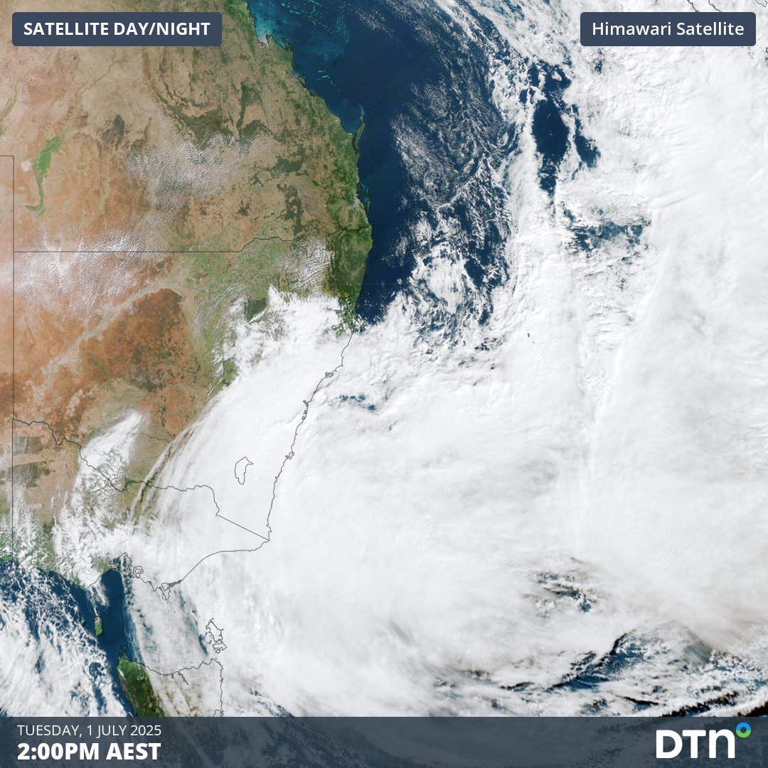
A coastal trough located off the southeast Queensland and northeast NSW coast rapidly intensified into a low pressure system overnight into Tuesday morning. This ferocious intensification, which meteorologists refer to as explosive cyclogenesis, can be seen playing out in the video below.
Video: Satellite imagery across eastern NSW and the Tasman Sea showing the East Coast Low rapidly developing on the morning of Tuesday, July 1, 2025.
Widespread 24-hour rainfall accumulations to 9am on Tuesday of 20-40 mm have been recorded between Noosa, in southeast Queensland and Ulladulla on the NSW’s South Coast. Heavier falls of 70 to 120 mm were also recorded around Jervis Bay and north of Newcastle, with notable falls of:
- 120mm at Jervis Bay Airfield
- 101mm at Currarong
- 84mm at Vincentia
- 80mm at Meldrum
Video: 24-hour Quantitative Precipitation Estimates (QPE) between Monday, June 30, and 9am on Tuesday, July 1, 2025. The QPE is an estimate of how much rain fell during the previous 24 hours.
East Coast Low forming through ‘explosive cyclogenesis’
The coastal trough that intensified overnight into Tuesday morning had a minimum pressure of about 1014 hPa on Monday night. However, once the low started to rapidly deepen, its central pressure had already dropped by 8 hPa 6 hours later at 4am on Tuesday.
The central pressure of the developing East Coast Low was down to about 1002 hPa by 10am on Tuesday. With further deepening expected on Tuesday, the system is expected to meet the criteria for it to be classified as a ‘bombing cyclonic low’ at this latitude, sometimes referred to as a ‘bomb cyclone’.
This process of rapid and explosive intensification is a necessary condition in the formation of a high impact East Coast Low as we’re seeing forming near the NSW coast.
Video: forecast Mean Sea Level Pressure (MSLP) and 6-hour rainfall between 10pm Monday, June 30 and 4am Wednesday, July 2, 2025.
The Tasman Sea has seen several “bomb cyclones” in the past months through the formation of significant Tasman Lows meeting the rapid deepening threshold. This low will however be notable due to its proximity to the coastline, making it the first East Coast Low since July 2022.
East Coast Low reaches peak intensity near Sydney
On Tuesday morning, the East Coast Low was located east of the NSW Central Coast. It is forecast to edge slowly closer to Sydney and the Central coast during Tuesday, possibly coming within 100 kilometres of the coast.
The central pressure of the system should reach its lowest value on Tuesday evening or Wednesday morning, possibly dropping to a central pressure value below 990 hPa.
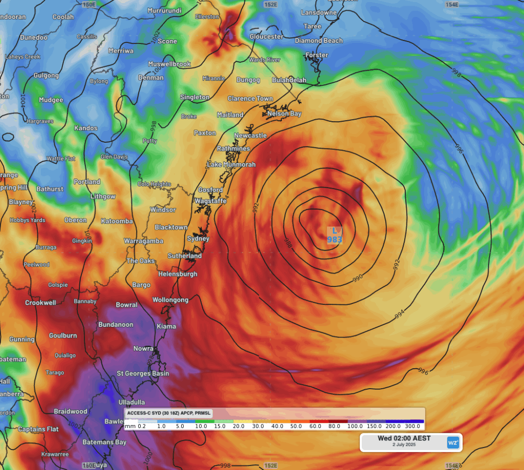
Image: forecast MSLP and 22-hour accumulated rainfall to 2am on Wednesday, July 2, 2025.
The proximity to the coast means that intense rain, damaging winds and hazardous surf are all being generated and sent into nearby areas to the south and west of the low. This includes most areas between Newcastle and Moruya, including Sydney and Wollongong. Heavy disruptions to transport, aviation and utility industries are coming as a result of these strong winds and intense flooding rainfalls.
Heaviest rain shifting south of Sydney
Heavy rain spread south across the Hunter on Monday night and into the Sydney region on Tuesday morning. Periods of heavy rainfall are still expected, most likely on Tuesday afternoon and again on Wednesday morning. However, the heaviest rainfalls are most likely further south into the Illawarra and South Coast.
Accumulated falls of 40-60mm are still expected across most of the Sydney and Hunter region in the coming 24 hours or so into Wednesday, with isolated locations receiving up to 100mm.
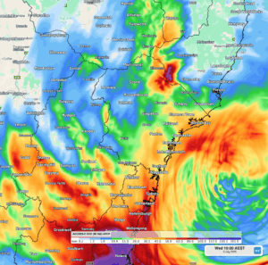
Image: Forecast 24-hour rainfall to 10am on Wednesday, July 2, 2025, across central NSW.
Heavy, intense and flooding rainfall for Illawarra and South Coast
Areas north from Ulladulla saw rainfall intensify late on Monday night, amounting to 20-40mm of rainfall since, with the Jervis Bay area recording 70-120mm to 9am on Tuesday.
Flooding rainfall is set to intensify on Tuesday afternoon, with a deep stream of moist southeasterly winds around the low converging with the local topography and opposing wind flow. As seen below, most of the Illawarra and South Coast regions and parts of the Southern Tablelands are expecting rainfall accumulations of 100-150mm over the next 24 hours, with areas between Jervis Bay and Bermagui seeing the potential for up to 300mm.
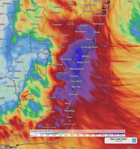
Image: 24-hour rainfall forecast to 10am on Wednesday, July 2, 2025, across the NSW South Coast region.
Powerful and damaging-to-destructive winds batter the coast
As the East Coast Low reaches peak intensity on Tuesday and Wednesday, strong and powerful winds will impact much of eastern NSW. Wind gusts reaching 130 km/h are possible along the coastline south of about Seal Rocks, with gusts of 80-100 km/h also possible across a more widespread swath of NSW on and east of the Great Dividing Range.
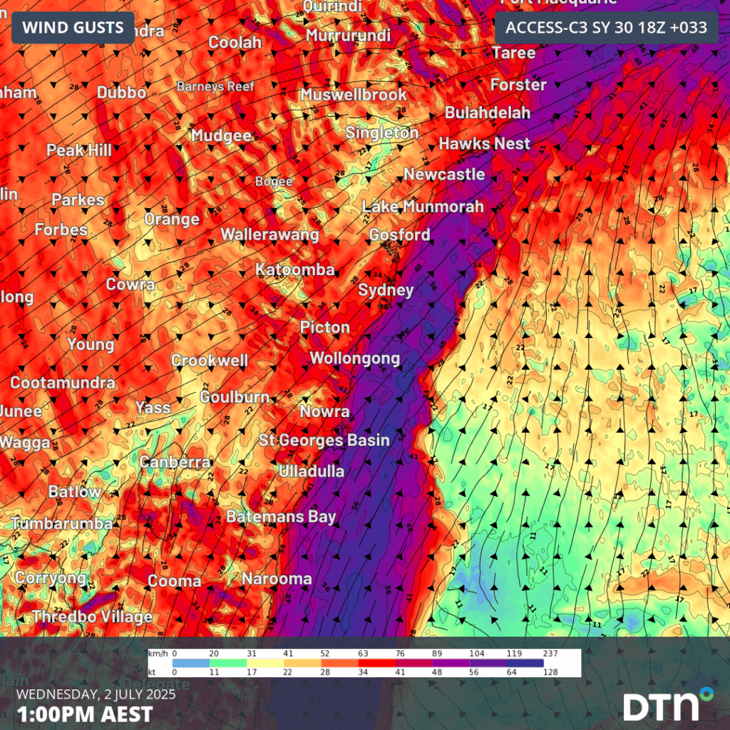
Image: 10m wind gusts at 1pm on Tuesday, July 1, 2025.
The strong winds are whipping up large and unruly surf across the NSW coastline with a Coastal Hazard Warning in place for the coast between Moruya Heads and Seal Rocks.
How DTN APAC Risk Communicators are supporting businesses through this East Coast Low
From Transport to Utilities, and Ports to Offshore energy farms, our Risk Communicators can help your business across Australia and New South Wales plan ahead and make confidence decisions when severe weather impacts.
Our Risk Communicators work closely with you to analyse how weather impacts your operations and communicate potential risks. We can then support your risk management planning, and provide situational awareness and post-event reporting when extreme weather events hit hard.
DTN APAC, is a diverse team, with global forecasting, product development and analytics expertise. Couple this with extensive industry experience spanning Aviation to Energy, and we are primed to assist you in strengthening your operational strategies when responding to weather disruption.
We consult with you to understand the nuances of your operations and your existing procedures and policies. We can then assist in creating communication structures, safety strategies and procedures to mitigate the risks that may impact your workforce, assets and uptime.
Our Risk Communicators are working closely with industries and businesses likely to be affected by this week’s East Coast Low, in order to mitigate the risk of damaging and long lasting impacts. Our weather risk communicators deliver short- to long- term guidance from:
- hourly-event weather monitoring (assisting you when severe weather is about to hits and is likely to clear).
- week to month operational planning based on likely timing of increased rain or low pressure development.
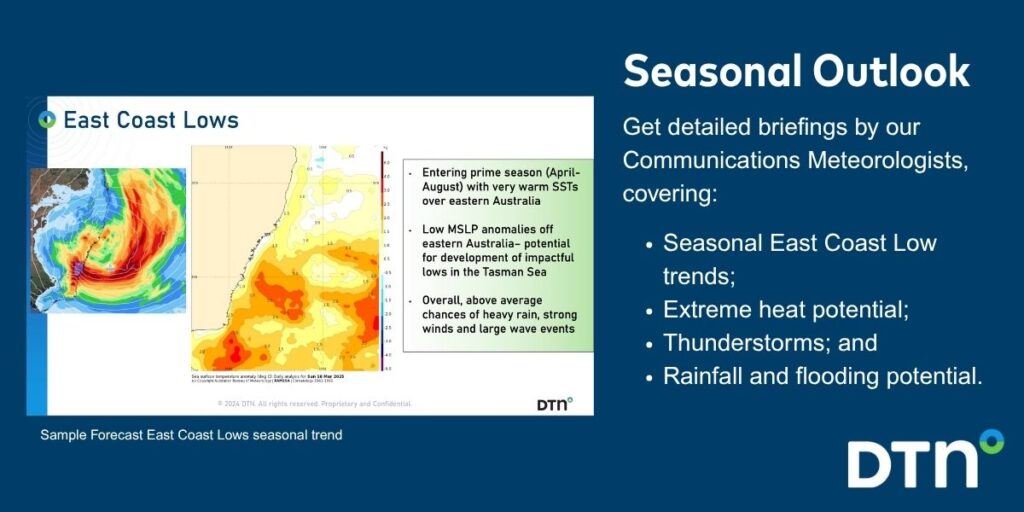
- seasonal long term planning based on climate drivers and the likely trends across the coming months.
As seen below, long range forecasts provided by our weather risk communicators at the start of autumn signaled for increased activity in the Tasman Sea over the coming autumn and winter.
We deliver clear and comprehensive weather data that you can’t get anywhere else, personalised risk assessments and briefings to you and your team, so that your critical decisions can be made with confidence.
We are available 365 days a year, so you always have the timely guidance you require, especially when severe conditions hit.
You have our insights to rely on to see you through complex situations, minimising potential loss of profit and maximising the safety of your staff and assets.
Learn more about our large range of industry leading products and services or email us at sales.apac@dtn.com


