Intense flooding rainfall, powerful winds and large waves impacted Hong Kong and southern China on Sunday as Typhoon Wipha crossed the region cancelling hundreds of flights and resulting in local closures of businesses.
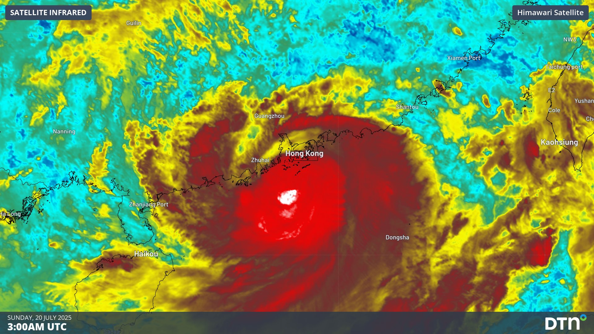
The sixth tropical storm of the western Pacific typhoon season intensified into Typhoon Wipha early on Sunday, July 20, 2025. The satellite imagery below shows the typhoon coming very close to Hong Kong, before making landfall over the neighboring Guangdong province.
Video: Visible satellite imagery showing Typhoon Wipha over the South China Sea on Sunday, July 20, 2025.
Wipha moved close to the Philippines’ Luzon Island on Friday and Saturday as the system tracked west into the South China Sea. Deep feeds of tropical moisture delivered 150-250mm of rain to northern Luzon Island and eastern Taiwan, with some areas receiving over 400mm of rain, leading to local flooding, cancellations of domestic flights and suspension of ferry services.
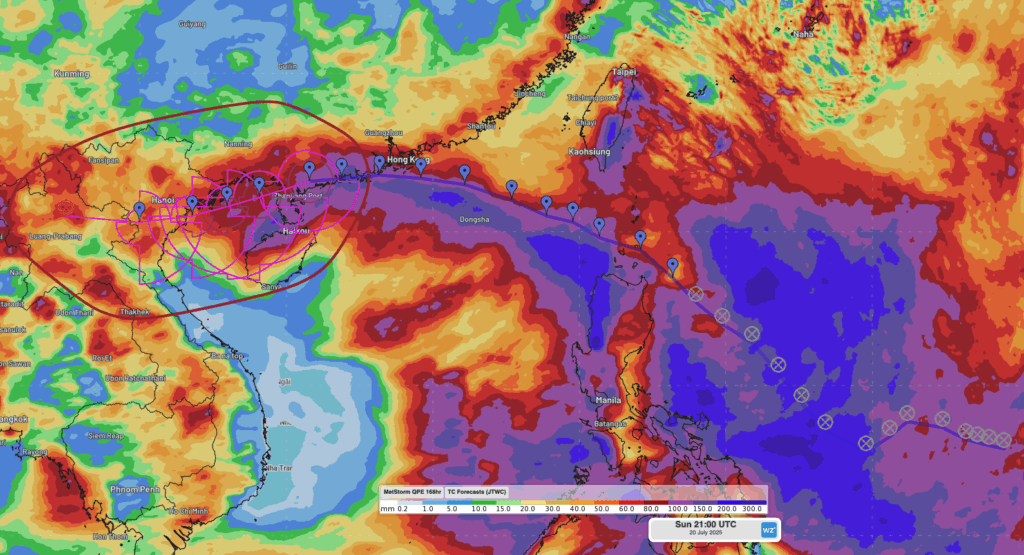
Image: DTN’s Quantitative Precipitation Estimates (QPE) of weekly rainfall to 5am CST on Monday, July 21, 2025, over the Philippine Sea and South China Sea, with overlaid observed and forecast JTWC storm track as seen in the DTN APAC Stormtracker.
Flooding and flight cancellations in Hong Kong
Wipha came within close proximity to Hong Kong around midday on Sunday, with strong winds exceeding 63 knots estimated near the core of the system.
Video: Enhanced infrared satellite Imagery showing Typhoon Wipha coming close to Hong Kong on Sunday, July 20, 2025.
Over 500 flights in and out of Hong Kong have been cancelled, with closures of public transport, schools and some hospital facilities also affecting the city. A T10 typhoon signal was issued by Hong Kong for nearly seven hours. The T10 signal is the highest warning level issued for hurricane strength winds. The last T10 signal was issued in 2023, during Super Typhoon Saola.
Peak sustained winds (and gusts) on Sunday reached:
- 171 km/h (gusting to 234 km/h) at Ngong Ping
- 132 km/h (gusting to 176 km/h) at Green Island
- 127 km/h (gusting to 173 km/h) at Cheung Chau Beach
- 105 km/h (gusting to 129 km/h) at Tap Mun
- 97 km/h (gusting to 117 km/h) at Tai Mei Tuk
Wipha re-intensifying heading towards Vietnam
After tracking west across the Guangdong province, Wipha is now moving back offshore between the Guangxi province and Hainan Island. Over the warm waters of the Beibu Gulf, Wipha is expected to re-intensify as it tracks westwards. Uncertainty remains elevated on the exact timing and location, but Wipha should cross back over land somewhere along Vietnam’s Red River Delta coastline on Tuesday.
Wipha’s second landfall will bring further flooding rainfall to parts northern Vietnam, Laos, northern Thailand and Myanmar (Burma). The image below shows accumulated rainfall across the coming 4 days, with Wipha’s track clearly shown crossing the region. Widespread falls of 200-300mm will bring flooding, displacing people and disruptions to transport through landslides.
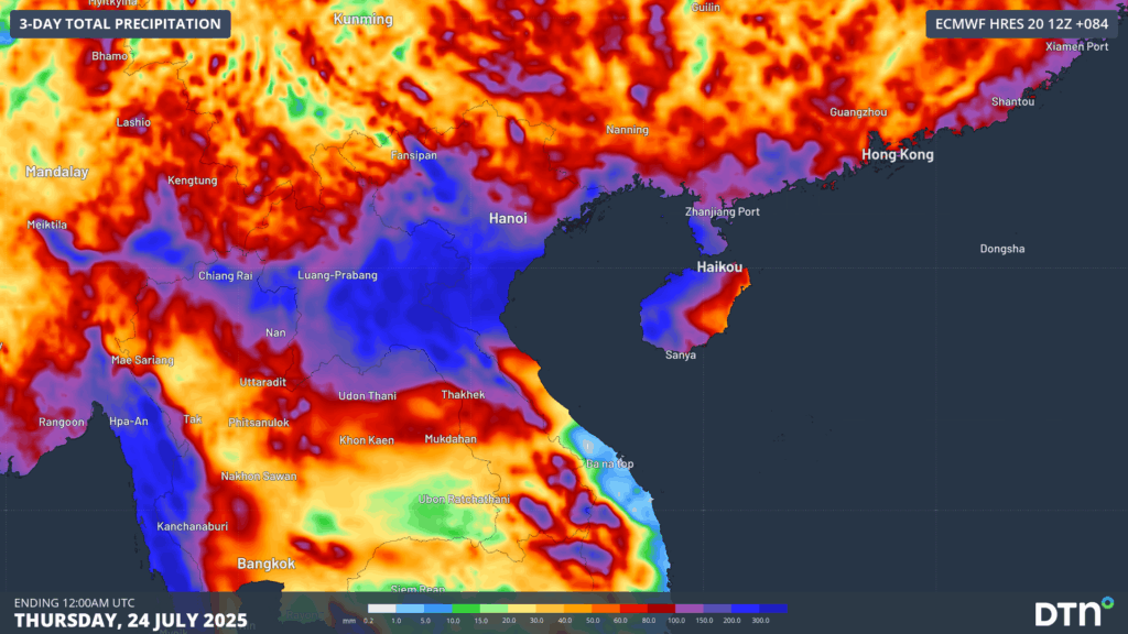
Image: Accumulated 3-day rainfall across mainland southeast Asia to Thursday evening, July 24, 2025.
While showers and less intense rainfall will persist for 2-3 days following Wipha’s passage, more settled conditions will develop over southern China and Vietnam later in the week, and over Laos, northern Thailand and Myanmar (Burma) over the weekend and early next week, helping the recovery effort across the region.
How DTN APAC supports businesses through typhoons
DTN APAC specialises in industry-leading forecast, alerting and threat analysis of tropical cyclones across Australia and Asia, offering you expert, customised solutions when the weather turns wild.
Providing rapid-update forecast information, we alert you to any low-pressure system gaining power within your region and, unlike other providers, can track its development out to 7 days. This gives you the time to prepare and safeguard your staff, sites and assets.
You will have the most precise weather intelligence charting rainfall, wind speeds and potential storm surges to help you make critical decisions quickly. Whether it’s adjusting key work schedules, protecting your staff or securing your site, we have the alerting capability to keep you steps ahead of the storm.
As the climate delivers increasingly severe weather events, their potential to impact your business operations grows.
Whether it’s preparing for the coming season’s tropical storm potential, or rapid-response forecasting with a typhoon approaching, or simply ensuring your operations team is equipped to confidently make decisions ahead of severe weather, our weather Risk Communicators are here for you.
Our weather risk communicators deliver short- to long-term guidance from:
- hourly-event weather monitoring (alerting you of impending destructive winds and heavy rain ahead of a tropical cyclone).
- week to month operational planning based on likely timing of increased monsoonal rain or periods of reduced cyclone activity.
- seasonal long term planning based on climate drivers and the likely trends across the coming months.
We deliver clear and comprehensive weather data, personalised risk assessments and briefings to you and your team, so that your critical decisions can be made with confidence.
We are available 365 days a year, so you always have the timely guidance you require, especially when severe conditions hit.
You have our insights to rely on to see you through complex situations, minimising potential loss of profit and maximising the safety of your staff and assets.
Learn more about our large range of industry leading products and services or email us at sales.apac@dtn.com


