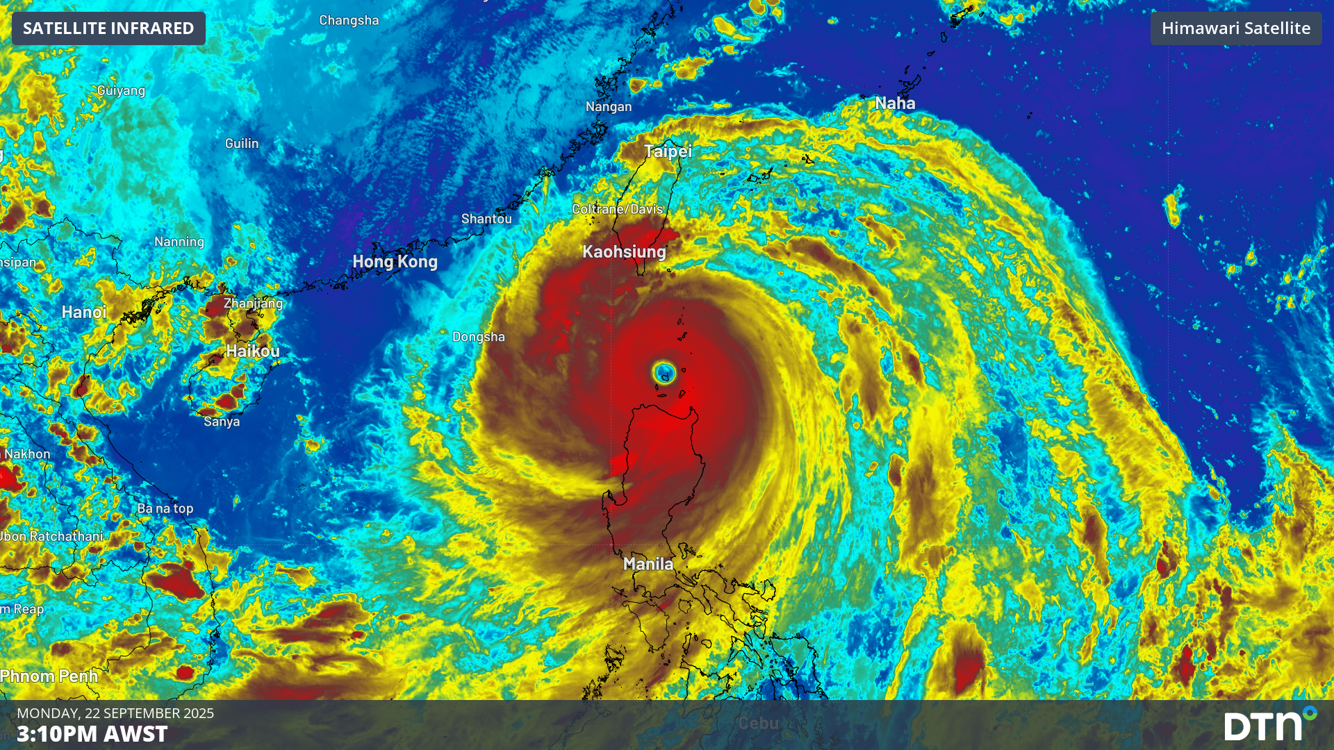
Japan’s Himawari-9 satellite has captured striking images of Super Typhoon Ragasa – known locally as Nando in the Philippines – bearing down on the Babuyan Islands on Monday and causing massive disruptions to industries across the region.
Typhoon Ragasa underwent rapid intensification late last week and became the first super typhoon so far this season in the Northwest Pacific region.
As Super Typhoon Ragasa approached Babuyan Island on Monday, it was a colossal system with an eye measuring 40 nautical miles (74 km) in diameter and peak wind gusts of around 175 knots (324 km/h) near its core. For comparison, Tropical Cyclone Yasi’s peak wind gusts were around 285 km/h.
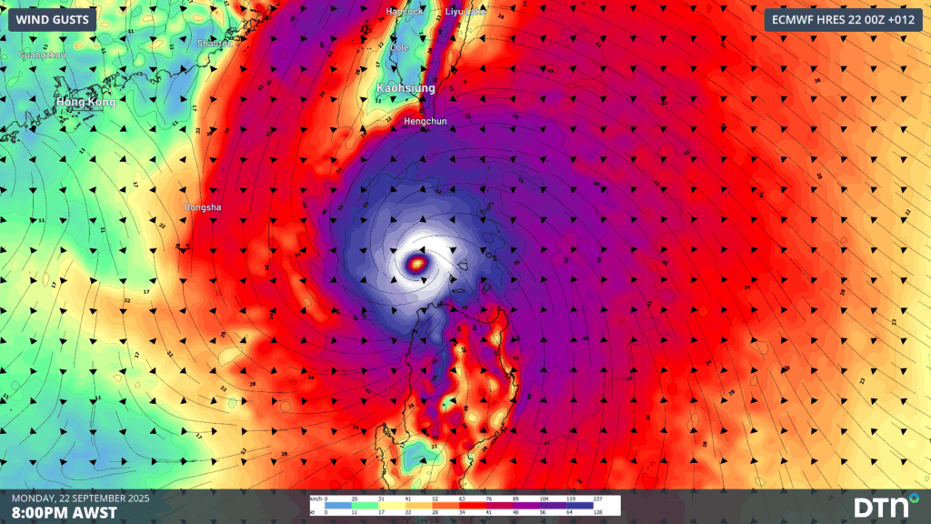
Image: Forecast wind gusts at 8pm Philippines time on Monday, September 22, 2025.
The Himawari-9 satellite was in an ideal position to watch Super Typhoon Ragasa barrelling towards the Philippines on Monday. The images captured by the satellite revealed the immense power of this huge typhoon.
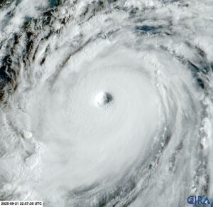
Image: Visible satellite image of Super Typhoon Ragasa on Monday, September 22, 2025. Source: RAMMB/CIRA
One of the standout features in the satellite images of Ragasa is the presence of mesovortices, which are small-scale circulations of air near the typhoon’s eyewall. Mesovortices can only be seen in satellite images when the eye is clear of high cloud, which is a sign of a mature and powerful typhoon.
Mesovortices in the eye of a typhoon can be extremely dangerous as they are capable of producing very destructive winds. The strongest wind gust ever reliably measured on Earth was 220 knots (407 km/h) in the eyewall of Tropical Cyclone Olivia in 1996 over Australia’s Barrow Island. This gust is believed to have been associated with a mesovortex.
Video: Super Typhoon Ragasa approaching the Philippines on Monday.
Ragasa is expected to move towards the west over the next few days, taking a path that will impact parts of the Philippines, China and Vietnam. Rainfall totals of around 300 mm are likely, with localised deluges in excess of 700 mm set to trigger flash flooding and landslides. Life-threatening storm surges exceeding 3.0 m are expected to inundate low-lying coasts of Batanes, northern Cagayan and Ilocos, while seas of 10–14 m will make conditions perilous for all marine vessels over the next 24-36 hours.
![]()
Image: DTN Stormtracker showing accumulated rainfall to Friday, September 26, 2025 and Typhoon Ragasa’s track as it moves west towards southern China.
More than 10,000 people have been evacuated from northern and central Luzon, while the major aviation hub of Hong Kong Airport is set to halt all passenger flights for 36 hours, causing major disruptions to the aviation industry.
How DTN APAC supports businesses through typhoons
DTN APAC specialises in industry-leading forecast, alerting and threat analysis of tropical cyclones across Australia and Asia, offering you expert, customised solutions when the weather turns wild.
Providing rapid-update forecast information, we alert you to any low-pressure system gaining power within your region and, unlike other providers, can track its development out to 7 days. This gives you the time to prepare and safeguard your staff, sites and assets.
You will have the most precise weather intelligence charting rainfall, wind speeds and potential storm surges to help you make critical decisions quickly. Whether it’s adjusting key work schedules, protecting your staff or securing your site, we have the alerting capability to keep you steps ahead of the storm.
As the climate delivers increasingly severe weather events, their potential to impact your business operations grows.
Whether it’s preparing for the coming season’s tropical storm potential, or rapid-response forecasting with a typhoon approaching, or simply ensuring your operations team is equipped to confidently make decisions ahead of severe weather, our weather Risk Communicators are here for you.
Our weather risk communicators deliver short- to long-term guidance from:
- hourly-event weather monitoring (alerting you of impending destructive winds and heavy rain ahead of a tropical cyclone).
- week to month operational planning based on likely timing of increased monsoonal rain or periods of reduced cyclone activity.
- seasonal long term planning based on climate drivers and the likely trends across the coming months.
We deliver clear and comprehensive weather data, personalised risk assessments and briefings to you and your team, so that your critical decisions can be made with confidence.
We are available 365 days a year, so you always have the timely guidance you require, especially when severe conditions hit.
You have our insights to rely on to see you through complex situations, minimising potential loss of profit and maximising the safety of your staff and assets.
Learn more about our large range of industry leading products and services or email us at sales.apac@dtn.com


