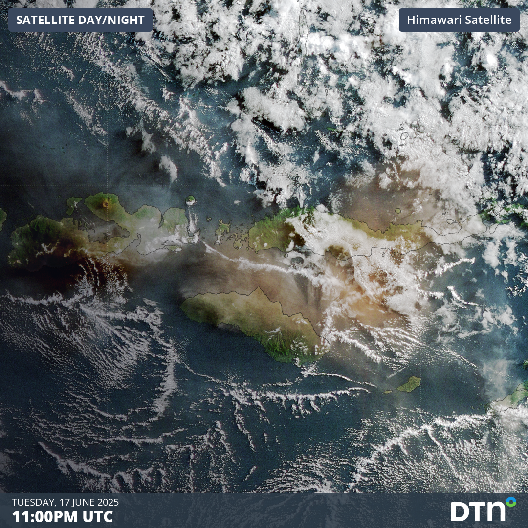
Lewotobi Laki-Laki, on the island of Flores, Indonesia, erupted on the afternoon of Tuesday, June 17, sending a large plume of volcanic ash and gases into the atmosphere.
Video: Volcanic Ash plume visible on satellite imagery on the morning of Wednesday, June 18, 2025.
Lewotobi Laki-Laki and Perempuan
The Lewotobi twin volcano is located on the eastern reaches of the island of Flores, Indonesia, approximately 800 kilometres east of Bali, Indonesia, and 1,000 kilometres northwest of Darwin, Australia.
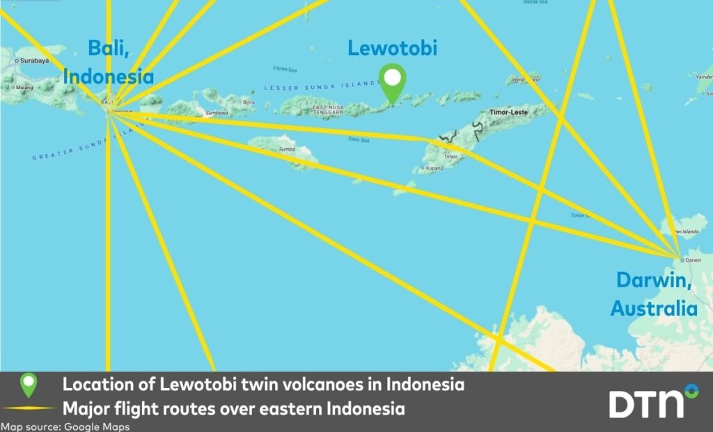
Image: Map showing the location of the Lewotobi twin volcanoes in Indonesia along with major flight routes over the region.
The two peaks that make up the volcano complex are Lewotobi Laki-Laki and Lewotobi Perempuan, or male and female Lewotobi, respectively.
Of the husband-and-wife pair, Laki-Laki has been most active recently. Ongoing eruptions since 2023 have displaced thousands of people, with a major eruption in November 2024 killing 9 people, destroying homes and disrupting international aviation. Laki-Laki erupted again in March and May of 2025, once again displacing people and disrupting aviation.
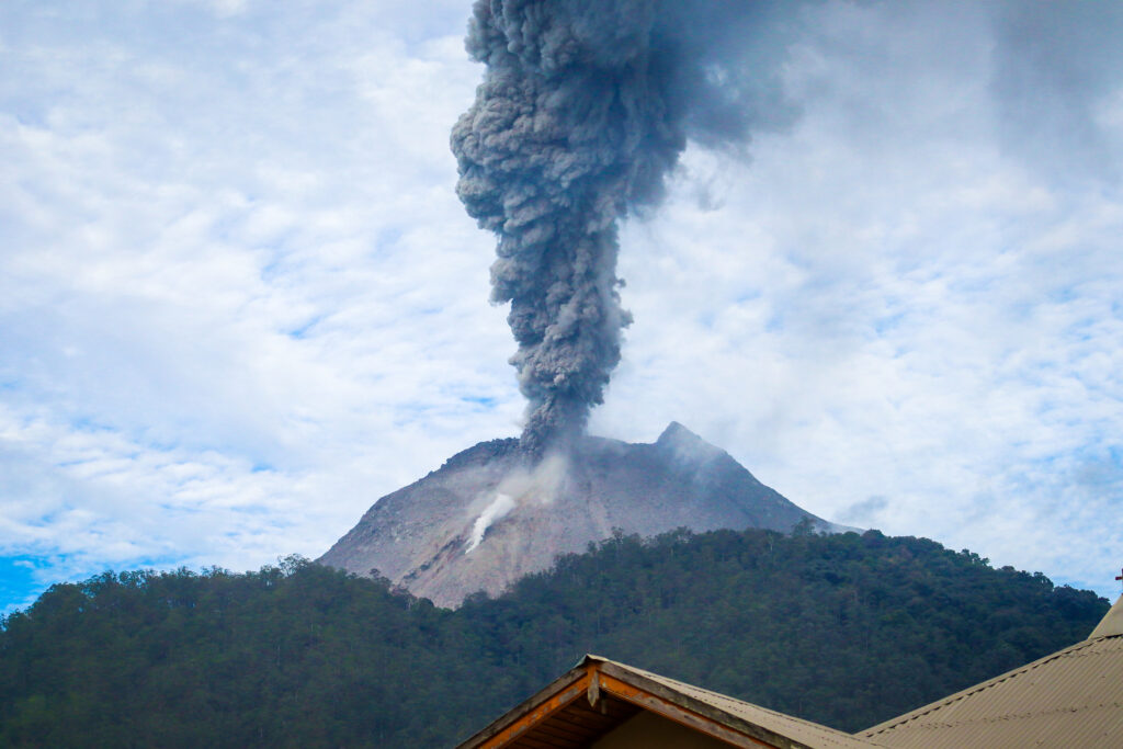
Image: Mt Lewotobi during a lesser eruption in June 2024. Source: iStock / Jimmy Tandjoeng
The Pacific ring of fire encompasses the Indonesian archipelago, with 130 active volcanoes in the country. Over 1,000 eruptions have been recorded over the course of its history, with a deep cultural and spiritual lore attached to local volcanoes.
Aviation Code Red
Video: Enhanced infrared satellite imagery on Tuesday, June 17, 2025, at the time of the Laki-Laki Eruption.
At 5:35pm local time on Tuesday, June 17, 2025, Laki-Laki erupted once again, sending a volcanic ash plume high into the atmosphere. While there are no reports of deaths or damage to property, the ash reached over 10 kilometres into the atmosphere.
BREAKING: Mount Lewotobi Laki-laki in Indonesia has erupted ????
“There was an eruption of Mount Lewotobi Laki-laki on Tuesday, June 17, 2025, at 17:35 WITA with an observed ash column height of ± 10,000 m above the peak (± 11,584 m above sea level),” said the Volcano Observation… pic.twitter.com/lpWZnHQwk1
— Volcaholic ???? (@volcaholic1) June 17, 2025
The Volcanic Ash Advisory Centre in Darwin has issued an Aviation Code Red for the area, prompting domestic and international flights to avoid the region. No major airport disruptions have affected nearby tourism centres like Bali, but ash continues to be expelled into the atmosphere at this stage.
Video: Satellite imagery of enhanced volcanic ash is expelled from Lewotobi Laki-Laki on Tuesday, June 17, 2025.
The dangers of volcanic ash to aviation
Volcanic ash is made of small pieces of rock, crystal and glass. Aircraft unfortunate enough to fly through volcanic ash suffer from abrasion similar to sand blasting, which is damaging to windshields and the leading edges of the wings.
Glass particles in the ash melts in the engine, which can block the air flow and cause the engine to stall when the molten glass re-solidifies in the turbine.
Ash clouds are often projected tens of thousands of metres into the atmosphere over broad areas surrounding the eruption. Since most commercial jets cruise at around 8,000 to 11,000 metres, this makes them highly susceptible to damage from ash clouds.
The hazard was little understood until 1982 when a British Airways jet flying to Australia lost power in all four engines over Indonesia before regaining power at a lower altitude (where the atmosphere was free of ash). The problem occurred again as the jet ascended, so the pilot descended again and eventually pulled off a difficult emergency landing in Jakarta with minimal visibility due to the sand blasting effect on the windshield.
There’s a documentary about that flight on YouTube.
![]()
Image: The DTN APAC Stormtracker dashboard used in the aviation sector to track Volcanic Ash Advisories around the Lewotobi eruption.
DTN APAC delivers a proven aviation weather briefing system, developed in collaboration with the industry, to keep your enterprise performing at peak efficiency.
We meticulously tailor actionable weather intelligence to suit the scope of your company’s work, on the ground and in the air. Accurate and comprehensive international data informs your daily decisions on safety, fuel loads and staffing.
Working alongside our global network of partners and suppliers we collate the data to give you full situational awareness of both en route and port specific conditions. Weatherzone is accredited and adheres to standards for aviation meteorology set by the World Meteorological Organisation (WMO) and the International Civil Aviation Organisation (ICAO). Registered with the ICAO and providing safety critical OPTMET data with permission from Air Services Australia, our aviation services meet the industry’s stringent requirements.
This is weather intelligence delivered in an easy to visualise format. No matter what the weather has in store, we give you clear foresight to make informed decisions. For more information, please visit our website or email us at sales.apac@dtn.com.


