
Rain and thunderstorms are expected to spread over heatwave affected parts of northern India and Pakistan in the coming days, bringing much needed relief to people and infrastructure.
Northwest India and Pakistan have been scorched by intense heat reaching well into the 40s over the past two weeks. The capital of India, New Delhi, had its first day not reaching 40°C on Tuesday, April 29. The average maximum temperature for this time of year is 39°C for the capital. As seen in the map below, heat has started to contract west into Pakistan.
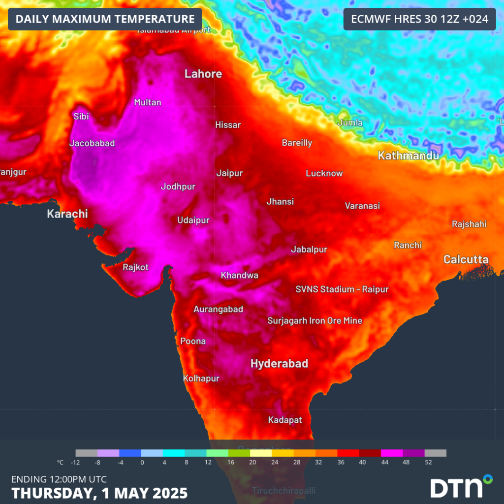
Image: Maximum temperatures on Thursday, May 1.
Milder daytime temperatures will encroach over northern India as moisture from the Arabian Sea moves over the sub-continent, as seen in the rainfall accumulation map below.
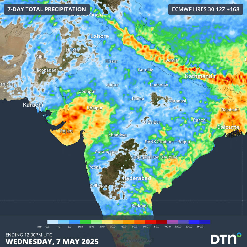
Image: Rainfall accumulations to Wednesday, May 7.
The rain and thunderstorms expected to spread over India in the coming week will bring much needed relief to people and struggling infrastructure, with much of northern India expected to drop closer to 40°C by the start of next week.
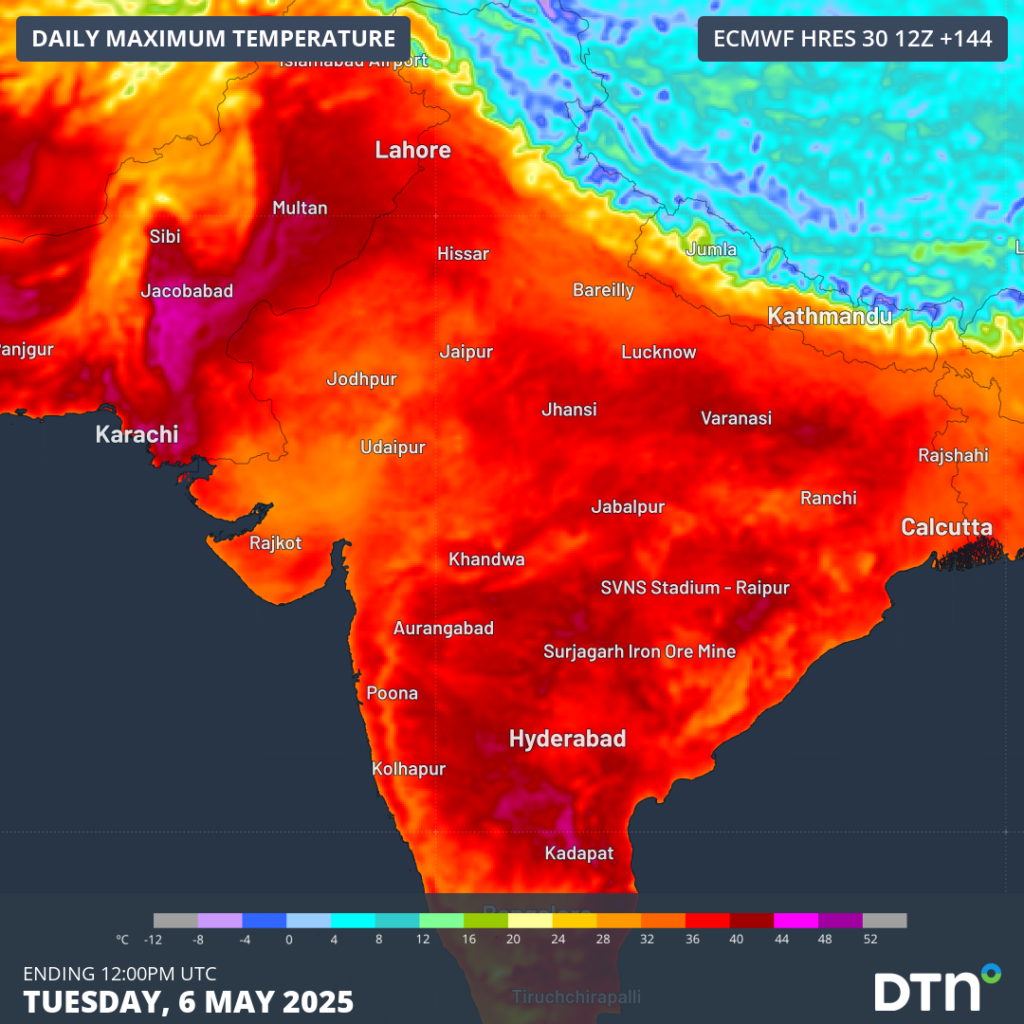
Image: Maximum temperatures on Tuesday, May 6.
How DTN APAC services the energy sector
When your energy operations are affected by weather extremes, we offer solutions to keep your productivity and profits high.
DTN APAC, supplies precise weather intelligence and analytics to support all aspects of your business, with a wide range of specialised services covering energy generation and weather forecasting, to site-specific severe weather alerting and historical reporting.
OpticastTM
DTN APAC operates Opticast, an ultra-local forecasting system. Providing an unprecedented level of accuracy and precision, Opticast rapidly updates every 10 minutes, intelligently adapting to local observations, and corrects forecasts based on historical evidence. Wherever you are based, we can provide you with the most accurate nowcasting and forecasting data out to 14 days so that you can mitigate operational and safety risks, and plan to make the most of severe weather windows.
Solar Forecasting and Generation
DTN APAC partners with Solcast, a DNV company – the world leader in real-time actuals and rapid-update solar forecasts.
Utilising Solcast’s satellite fleet, sky-imagers and the SCADA data collected from your solar farm, you will acquire not only forecasting capability, but a precise picture of your actual yield and PR. Specifically built to ensure you meet the requirements and reduce your exposure to costly penalties.
Wind
Utilising Opticast’s data, we provide wind power generation, operational and severe weather forecasting to improve your planning and protect your valuable staff and assets. Utilise generation forecasts for individual wind farms and state level at daily and hourly resolution.
DTN APAC’s Total Lightning Network ensures your wind farm is protected from severe storms by an alerting system that can be configured to your exact requirements, aligning with local site needs, procedures and legislation.
Hydropower
Using Opticast’s nowcasting and forecasting capabilities, you will have long-term outlook covering rainfall and extreme heat events out to 12 months. This can significantly improve your planning as you integrate the data with site-specific hydrological parameters.
DTN APAC’s Risk Communicators
Our Risk Communicators work closely with you to analyse how weather impacts your operations and communicate potential risks. We can then support your risk management planning, and provide situational awareness and post-event reporting when extreme weather events hit hard.
DTN APAC, is a diverse team, with global forecasting, product development and analytics expertise. Couple this with extensive industry experience spanning Aviation to Energy, and we are primed to assist you in strengthening your operational strategies when responding to weather disruption.
We consult with you to understand the nuances of your operations and your existing procedures and policies. We can then assist in creating communication structures, safety strategies and procedures to mitigate the risks that may impact your workforce, assets and uptime.
Rely on our insights to see you through complex situations, maximizing the safety of your staff and assets, and your uptime where possible.
To find out more about large range of products and services contact us at sales.apac@dtn.com


