The severe storm season started off with a bang last week, with damaging winds, tornadoes, heavy rainfall, and hail all seen in parts of southeastern Australia. The severe start to the season has many businesses planning for the summer ahead.
While severe storms can occur at any time of the year, they are most common between September and March. This of course is Australia’s summer or wet season when we see the warmest temperatures and high humidity air in some parts of the country.
Thunderstorms rely on a combination of the following factors to form;
- Humid air with enormous amounts of water vapor.
- An unstable environment- Buoyant air which is warm and moist.
- A lifting mechanism or a trigger – A cold front or trough in the region forcing air to rise rapidly.
So where do thunderstorms occur most often in Australia?
Weatherzone owns and operates the Weatherzone Total Lightning Detection Network (WTLDN), one of the most advanced networks of its kind in the world.
The capability to detect strike accuracies down to 100m, supports dangerous thunderstorm alerting, which is imperative to outdoor operations and infrastructure.
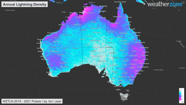
Our network has enabled us to calculate the annual lightning density during the last 6 years to date. During the last 6 years the most lightning strikes have been observed in eastern NSW, southeastern and northwestern QLD, the Top End in the NT and northwestern WA (pinks in figure 1).

Figure 1: Weatherzone Total Lightning Network (WTLN) annual lightning density in Australia for the past 6 years to October 2021.
Storms are very frequent across the western Top End in the NT, including Darwin during the wet season (figure 1). This shouldn’t come as a surprise, as during the wet season in Darwin, an afternoon storm is regular occurrence on the forecast.
Thunderstorms occur in Darwin on average 80 days a year, while the northern tip of WA and QLD see around 60 days. Northeastern NSW averages 30-40 thunderstorm days a year (figure 2).

Figure 2: Average Annual thunder day map Australia, Source: BOM
During the wet season, heat, humid air and instability are usually abundant across Northern Australia, generating frequent monsoonal showers and thunderstorms in the region.
How can Weatherzone help this severe storm season?
Weatherzone can alert our customers of imminent Severe thunderstorms, severe weather or tropical cyclones. Our Early Warning Alert System (EWA) notifies the insurers customers of the imminent severe weather, enabling them to get their cars under cover. Our service can reduce the number of claims due to hail and severe weather and promote positive customer engagement.
It also enables greater visibility of impact weather for embargo purposes and it improves claim verification, as we provide historic storm information.
Weatherzone’s technology uses Titan Tracks and Weatherzone’s own Dangerous Thunderstorm Alerts (DTAs) to send customers alerts of imminent severe weather 30 minutes in advance. The high precision alerts have the ability to alert on the customers registered address, allowing them sufficient time to take action.
DTAs work by measuring the frequency of lightning flashes, which directly correlate with the severity of the weather in the form of heavy rain, damaging winds, large hail or tornadoes. Titan Tracks the storms direction and speed, with the system alerting based on Titan and DTAs.
Weatherzone’s storm tracker provides businesses with a full situational awareness of weather threats. Including the alerts, real time lightning, DTA’s, Titan Tracks, radar, satellite, weather, fire, gridded observations and custom overlays.
We can also alert for other weather perils, such as flooding rainfall, damaging winds and tropical cyclones.
Weatherzone can deliver these alerts directly to your customers via SMS or email (figure 3).

Figure 3: Weatherzone’s alerts directly to customer via SMS.
For more information on our alerting service or the severe storm season, please contact us at apac.sales@dtn.com.


