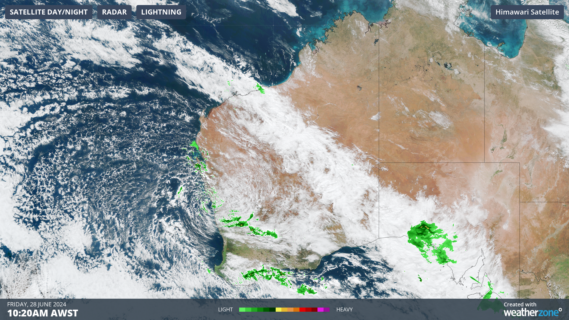
Yet more rain fell across western and southwestern parts of WA on Thursday and overnight into Friday, including areas that have had a remarkably dry period.
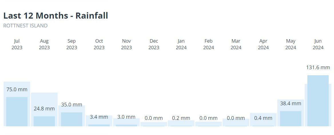
Rottnest Island is enjoying its first above-average month of rainfall in 12 months – a period that included a record dry spell of seven months with just 7 mm of rain in total from October through to the end of April.
“Widespread rain for Western Australia” was the headline of a story we wrote on Tuesday, and so it has turned out. Some of the observations of note to 9 am Friday (AWST) include:
- Numerous falls of between 10 mm and 20 mm in the Pilbara region, which is significant rain for that area at this time of year – even though it’s far from unheard of as the driest time is between August and October, when almost no rain typically falls.
- Falls approaching 20 mm in the Goldfields, including 19.2 mm at Leonora Airport, a couple of hours north of Kalgoorlie.
- Useful falls approaching 20 mm in the Central West, including 16 mm at Geraldton Airport, which has had a very wet June with more than double its monthly average rainfall.
- Widespread falls exceeding 10 mm further south along the coast, with some heavy readings including 56 mm at Lancelin north of Perth, while the city of Perth itself saw 7.4 mm.
The overnight rain was caused by a low pressure system just north of Perth and several associated troughs, and continued the trend of consistent rainfall events in the west in June 2024.
The WA rain story this month hasn’t been one of huge totals in most locations, but of rainfall roughly in line with long-term averages. After the rain taps turned off early in mid-spring and stayed dry until much later than usual in autumn, an average rainfall month to start off winter would be feeling like a deluge to locals.
Source: BoM.
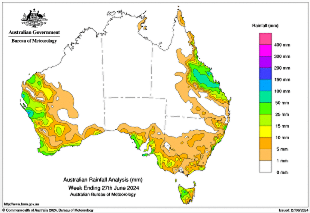
The chart above shows rainfall for Australia in June 2024 to date. As you can see, Western Australia has finally gotten its fair share, although a mostly dry week now lies ahead after rain eases in most areas on Friday.
Miningzone, by DTN APAC, is the only weather tracking and alerting solution purpose-built for the resources sector.
Miningzone is the proven and trusted turnkey solution –deployed at over 400 mines globally – offering you tailored forecasting and alerting systems to protect your valuable staff and assets.
Weatherzone’s integrated services are intuitive and user-friendly, providing you with the specific weather and blast data needed to gain a complete environmental picture.
You will have access to our lightning and severe weather tracking and alerts, EPA-approved blast dispersion modelling, thunderstorm tracking and high precision and site-specific forecasting, along with comprehensive reporting capacity.
Precise, market-leading data is delivered via multiple platforms including Weatherguard – our easy-to-use app – and can be fully integrated into your operational control or SCADA systems. To find out more, please contact us at apac.sales@dtn.com.


