
Perth has enjoyed its wettest 24-hour period in over a year, after 43.8 mm fell in the 24 hours to 9 am Thursday.
Weatherzone meteorologist Ashleigh Madden wrote on Wednesday afternoon that a cold, wet change was heading the way of southwest SA, and the cold front duly arrived on Wednesday evening.
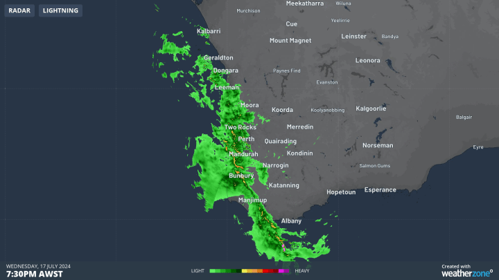
As you can see in the loop below, the heaviest showers moved through between 7:30 pm and 9:30 pm local time along with a narrow line of storms. A 12-hour period of frequent showers then followed the two-hour burst of heavy rain.
- The 43.8 mm to 9 am narrowly exceeded the 43.2 mm that fell in Perth on June 2.
- This made it the heaviest rain day in the WA capital since June 5, 2023, when 71.2 mm was recorded.
- It also brought Perths running monthly total to 90.2 mm.
- While there’s still a way to go to reach the July average of 146.3 mm, Perth should get close to that mark in the next week or so, with showers forecast this weekend and heavier rain due in the new week as another cold front approaches.
As the bar graph of Perth rainfall below shows, Perth has not exceeded its average monthly rainfall in any of the past 12 months.
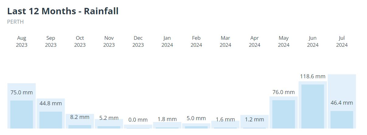
Note: The above graph does not include the overnight fall of 43.8 mm mentioned in this story, which brought the running monthly total to 90.2 mm.
Perth’s last above-average rainfall month was June 2023, which included the day mentioned above when 71.2 mm fell.
Meanwhile good falls were reported right across the southwest, including numerous inland locations with readings up to 25 mm, while Jurien Bay, just over two hours north of Perth, had the state’s highest reading with 55 mm.
Stormtracker is a severe weather solution that can assist you in observing, in real-time, any storm or event that has the potential to impact your business. Embedded in DTN APAC’ industry interfaces, the system gives you a time advantage when monitoring conditions developing over your infrastructure and location.
Stormtracker is our Global Information System (GIS) tracking tool, providing multiple weather layers and zoom controls overlaid on a map of your location and infrastructure. You can choose a snapshot or full screen view, depending on your requirements. The maps allow you to monitor all weather, and specifically any systems likely to cause risk for your business. You also have the capacity to observe:
- real time lightning and thunderstorm alerts
- localised lightning strike frequency
- official warnings for storm, cyclone, wind, flood and fire
- sentinel hotspot fires and fire agency current incidents
Stormtracker’s radar imagery updates every 10 minutes, so you are always able to respond rapidly to changing conditions. You can customise alerting to notify you when your staff or infrastructure are under threat. With increased situational awareness, your ability to make informed decisions quickly is optimised.
DTN APAC’ experience and intelligence gives you a clear path through complex situations. Let us assist you, offering actionable insight when extreme weather poses risk to your business. To find out more, please visit our contact page or email us at apac.sales@dtn.com.


