Prosper in a dynamic world
Search

WA snow potential as wintry weather arrives from today

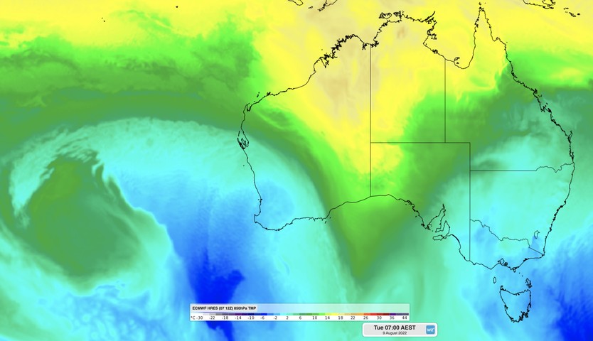
One of this season’s coldest air masses to cross southwestern Australia could produce hail near Perth and deliver a dusting of snow in the Stirling Ranges during the next 48 hours.

The satellite image below shows a long band of cloud arriving in southwestern Australia on Monday morning, revealing the location of a cold front. In the wake of this front, a large area of speckled clouds sitting off the west coast of Australia has formed in a pool of cold air that has drifted north from the Southern Ocean.

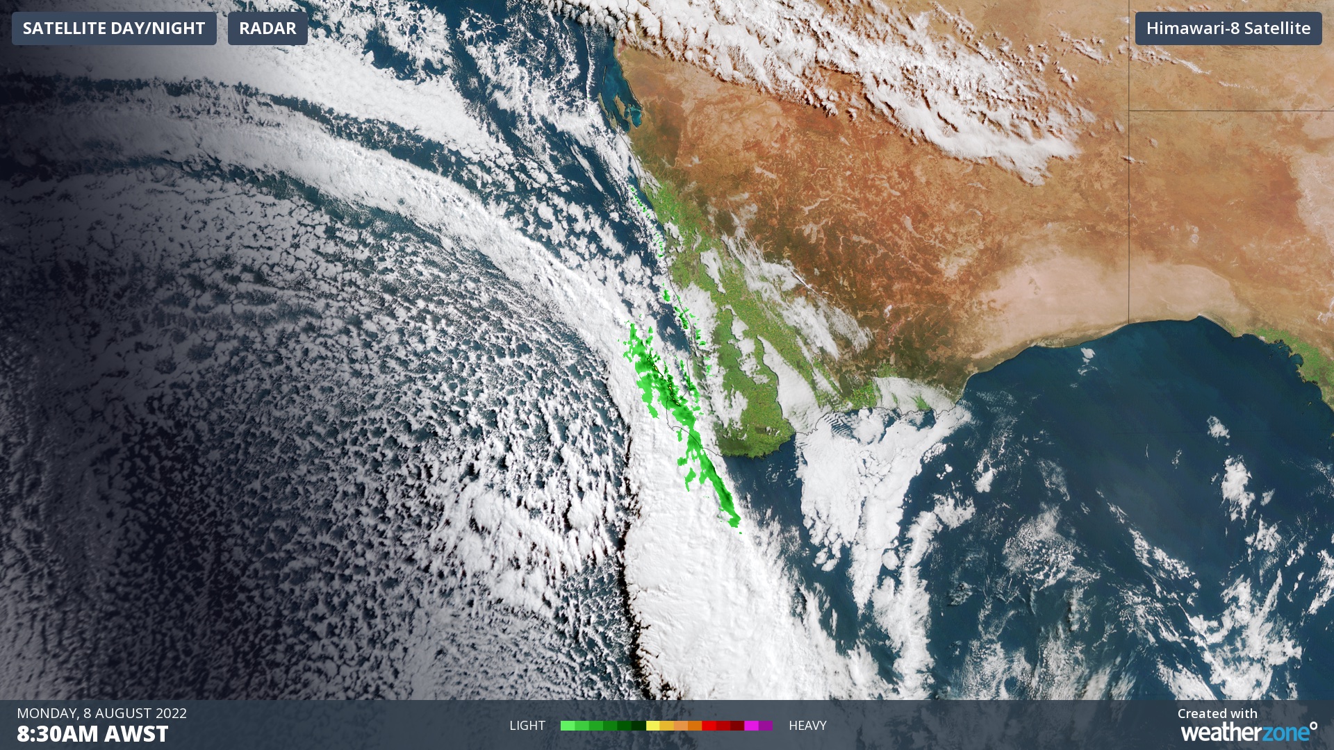
Image: Composite visible satellite and radar captured at 8:30am AWST on Monday morning.

The front and proceeding cold air will both move towards the east on Monday and Tuesday, passing over a broad area of southwestern WA.

Fortunately, this cold front is not as strong as the system that hit WA last week and caused the strongest wind gusts in years at some places. However, this week’s front will still pack a punch and cause a wintry mix of rain, hail, thunderstorms, blustery winds and possible snow.

The cold front will arrive in Perth around lunch time on Monday, causing a burst of blustery winds, squally showers and a noticeable drop in temperature. The front will then continue to sweep towards the east, reaching Esperance by around 9pm.

Cold air behind the front will allow showers to persist over the southwest of WA through Monday night and on Tuesday, with some areas likely to see small hail and thunderstorms. Models even suggest that temperatures will be low enough for a dusting of snow on the Stirling Range, most likely on Bluff Knoll.

Maximum temperatures will struggle to reach the low teens over southwestern WA on Tuesday, making this one of the coldest days of the year.

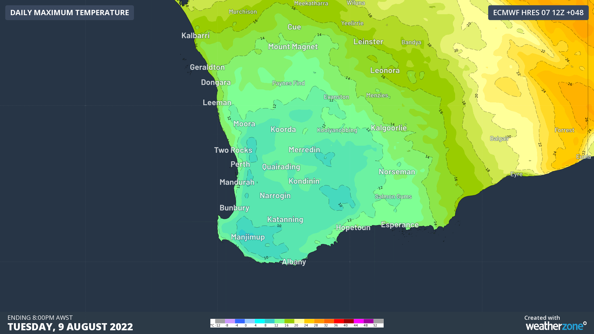
Image: Forecast maximum temperature on Tuesday, according to the ECMWF-HRES model.

Calmer weather and milder temperatures will return from Wednesday as a high pressure ridge starts to build over the region. For more information on our temperature or energy forecasts, please contact us at apac.sales@dtn.com.

Latest news

Satisfy your weather obsession with these news headlines from around the nation, and the world.

DTN Dangerous Thunderstorm Alerts in action with severe thunderstorms disrupting Perth industries

Severe thunderstorms impacted southwest WA and the Perth region on Sunday, December 14, 2025, triggering Dangerous Thunderstorm Alerts (DTA) by DTN for industries and businesses in the region. DTN operates Dangerous Thunderstorm Alerts (DTA) which alert businesses and industries to thunderstorms based on intensity and movement. These alerts provide advanced notice of thunderstorms moving into […]

How Australian East Coast port and maritime operations could be disrupted by tropical cyclones over the next two weeks

Port and maritime operations across Australia’s East Coast could be disrupted by increased tropical cyclone activity in the Coral Sea and southwest Pacific Ocean over the next two weeks. Meteorologists reference a large selection of Numerical Weather Prediction (NWP) models to forecast weather. A number of these NWP models are forecasting the development of tropical […]

Extreme fire danger and severe heatwave conditions spreading across SA, Victoria and NSW

Hot, dry and windy weather causing elevated fire danger and severe heatwave conditions are sweeping across southeastern Australia over the next three days, driving high energy demand and disruption to operations. Clear skies associated a large and slow-moving high pressure system have allowed hot air to build up over parts of northern, western and central […]

Heightened bushfire risk during the 2025-26 summer for WA, Victoria and NSW in latest AFAC Outlook

The Australian and New Zealand Council for fire and emergency services (AFAC) identified western and southern WA, Victoria and inland NSW as key regions that are at risk of heightened bushfire risk this summer. Parts of Australia have experienced severe soil moisture and rainfall deficiencies over the past months and years, while high fuel loads […]