Energy demand will surge across large areas of WA as daytime temperatures climb into the mid-40s, with the warmest December night on record possible for Perth.
The relentless heat will be caused by a stubborn high pressure system in the Bight, with prevailing easterly winds dragging an extremely hot airmass over northern WA, which will then extend down the west coast on the weekend.
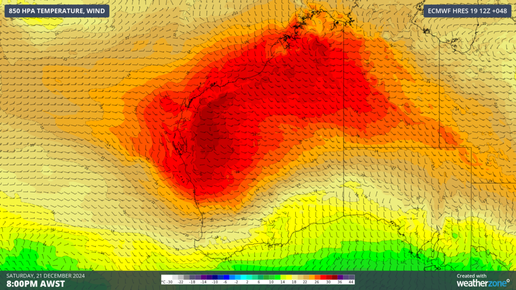
Image: 850hPa temperature and wind showing an extremely hot airmass sitting over much of WA at 8pm AWST on Saturday, December 21, according to ECMWF
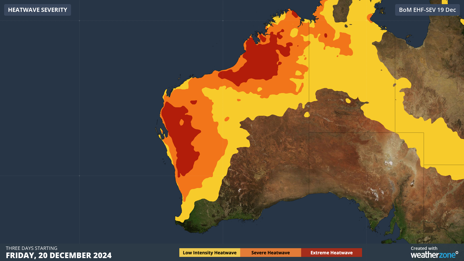
This set up is causing severe to extreme heatwave conditions across the north and northwest of the state which will filter down the west coast on the weekend.
The hot, dry and gusty easterly winds will also cause extreme fire danger across the Central and Lower West, the Great Southern and Central Wheat Belt districts on Sunday and Monday, when the heat peaks.

Image: Heatwave severity for three days beginning on Friday, December 20. Source: Bureau of Meteorology
Maximum temperatures will soar into the mid to high 40s in the state’s north, before impacting the west coast on the weekend into early next week. The heatwave will peak on Sunday and Monday, before a cooler change arrives in the southwest of WA on Tuesday just before Christmas.
Minimum temperatures will also remain in the mid to high 20s overnight across northern WA and the west coast, with Western Australians likely running their air conditioners overnight. This usage throughout the next four days will cause energy demand to spike in the state, putting pressure on the South West Interconnected System (SWIS) and North West Interconnected System (NWIS).
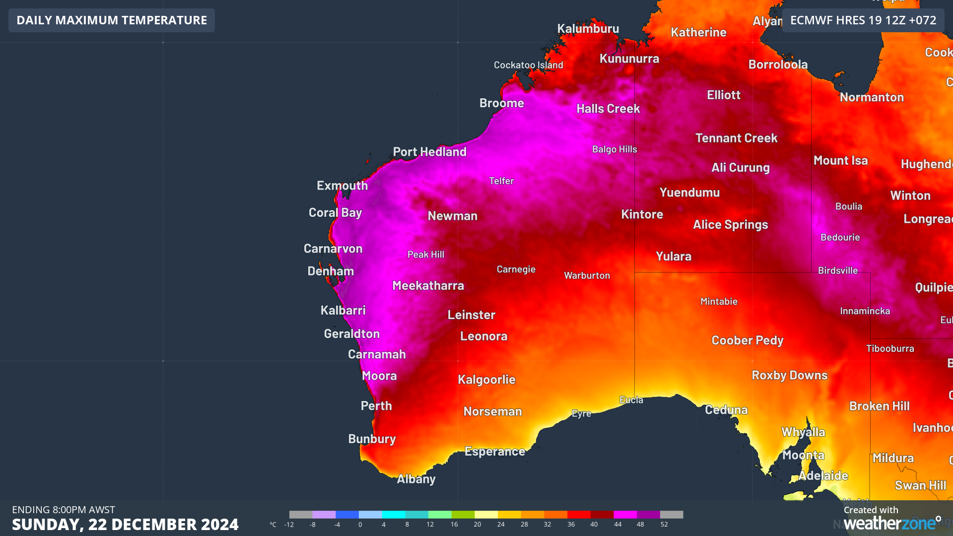
Image: Maximum temperature forecast for Sunday, December 22, according to ECMWF
The heat will also impact Perth, with temperatures expected to rise into the high 30s on Saturday, peaking in the low 40s on both Saturday and Sunday.
The heat will peak between midday to 4pm on Saturday and Sunday, with moderate seabreezes kicking in later in the afternoon, with gradual cooling. Winds will then tend to the east again in the evening meaning that minimum temperatures will also remain in the mid to high 20s in Perth on early Sunday and Monday mornings.
DTN’s model Opticast is forecasting Perth’s warmest December night on record, with the temperature expected to drop to only 27.9°C early on Monday morning. This forecast would beat the old record of 27.3°c from December 9, 2012. There is still some uncertainty around this forecast, due to some discrepancy on the strength of easterlies overnight, with the Bureau forecasting only 27°C.
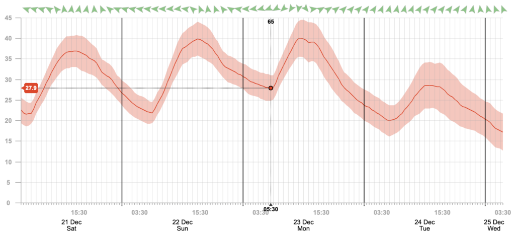
Image: DTN’s Opticast temperature forecast showing the times of peak heat, the warm minimum temperature Monday morning and the southerly arriving on Monday afternoon.
Looking ahead a southwesterly change will arrive on Monday afternoon cooling temperatures significantly, with maximums falling into the 20s until the following weekend.
DTN has grown to become the outright leader within the Australian energy market, serving wind, solar, hydro, trading, utilities and network companies.
You can’t control the weather, but you can gain precision insights to optimise your response. What lights us up is providing your energy business with tailored weather information to reduce your risk and keep you moving ahead of the curve.
Our services cover all aspects – from wind and solar generation to demand forecasts, wholesale markets to retail so, no matter where your company sits, we have solutions for you. We have worked closely with market participants to create products that meet the evolving needs of the sector, aiming to increase safety and profitability for our customers.
Benefit from the timely delivery of accurate weather information, allowing informed and effective decision-making. For more information please visit our website or email us at sales.apac@dtn.com.


