The eastern states of Australia have had an incredibly warm and sunny winter and this trend is set to continue.
The daytime temperatures in Sydney are set to soar, by winter’s standard, for 4-5 days from Friday.
Maximum temperatures in the Sydney Basin during this period are forecast to be a whopping 5-8 degrees above normal (figure 1).
Sunday night in Sydney is likely to be warm too, with the nighttime temperatures 5-6 degrees above the August average.
Brisbane and Archerfield are not missing the warmth either, with temperatures reaching 2-4 degrees above normal from Saturday through to Tuesday (figure 1).
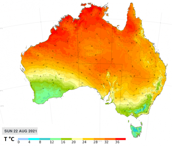
Figure 1: ECMWF maximum temperature on Sunday August 22.
What is causing the warm temperatures?
A series of cold fronts are passing southern Australia and failing to reach as far north as Sydney and Brisbane.
This set up is causing prevailing warm and dry westerlies, which are responsible for this perfect August weather.
While this type of weather pattern is not uncommon at this time of year, the number of warm days we have seen in Sydney this season has been surprising.
Unusual winter warmth for Sydney
Sydney has already registered two days over 25ºC so far this winter, one in late-July and the other on the first day of August.
This week’s warm spell has the potential to add up to three more days at or above 25ºC, which would take the season’s tally to between three to five in total.
It’s unusual to see so many days this warm during winter:
- Sydney hasn’t had three winter days at or above 25ºC since 2009.
- Having four winter days this warm has only occurred four times in the last 162 years of records.
- Five days at or above 25ºC has only happened once. This was in 1885, when there were eight.
A change is on its way
Looking ahead, a stronger cold front is finally expected to make it to the eastern states on Monday evening into Tuesday, dropping temperatures significantly after a considerable number of warm days.
On Monday ahead of this cold front, northwesterly winds are set to strengthen, before a gusty southerly change makes its way up the NSW and QLD coastline. There is the potential for wind warnings to be issued with this system early next week.
For detailed 14-day temperature and wind forecasting please contact us at apac.sales@dtn.com.


