Stretching high above Earth’s North and South Poles are two swirling columns of extremely cold air encircled by powerful winds. These whirlpools of frigid air and wind are each called the polar vortex, and they can have a big influence on weather patterns across the Northern and Southern Hemispheres.
What is a polar vortex?
A polar vortex is a large region of cold air and low pressure that sits above one of Earth’s polar regions throughout the year. Each polar vortex strengthens in winter, as polar temperatures plummet during months of darkness, and weakens in summer, as sunlight causes the air to become warmer above the poles.
Each polar vortex extends from the ground up through the stratosphere, reaching tens of kilometres into the atmosphere. Meteorologists typically refer to the polar vortex in two distinct sections:
- The stratospheric polar vortex sits about 10 to 50 km above Earth’s surface. This section of the polar vortex is well-defined and typically shaped like a circle or oval because it is not directly influenced by friction from the surface. The stratospheric polar vortex does not directly affect weather near Earth’s surface. Temperatures inside the stratospheric polar vortex can reach below -80°C.
- The tropospheric polar vortex extends from the surface up to the bottom of the stratosphere, spanning the lowest 8 to 12 km of the atmosphere. The tropospheric polar vortex sits in the same layer of the atmosphere as our weather, which means it can directly influence weather patterns across the Southern and Northern Hemispheres. The tropospheric polar vortex is influenced by surface friction, making it weaker and less well-defined compared to the stratospheric polar vortex, particularly close to the surface.
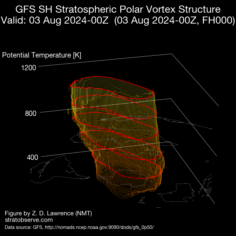
Image: A 3D representation of the Southern Hemisphere’s polar vortex structure on August 3, 2024. The lines in this vortex animation represent potential temperatures at different heights above the South Pole. Credit: StratObserve
When the polar vortex is strong and well established, it forms a roughly circular shape around the polar region and keeps cold air locked above Antarctica or the Arctic. However, if the polar vortex weakens, it can distort or even split, which allows cold polar air to spread away from Antarctica or the Arctic and venture into the mid-latitudes.
The images below show some examples of the Southern Hemisphere’s polar vortex at different strengths and shapes.
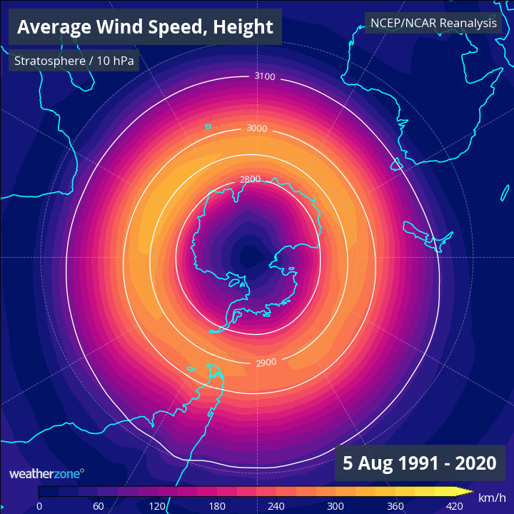
Image: A top-down view of the stratospheric polar vortex based on long-term average shape and size in early August, using data from 1991 to 2020. This image shows wind speed at the 10hPa level of the atmosphere, which is about 30km above the surface. The polar vortex in this example is circular in shape and centred directly above Antarctica.
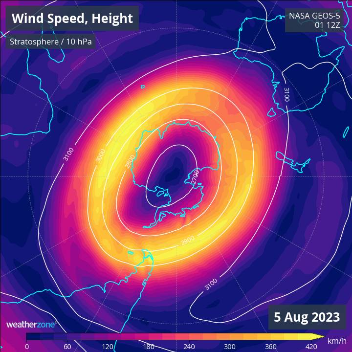
Image: A top-down view of the stratospheric polar vortex in early August 2023. This image shows wind speed at the 10hPa level of the atmosphere, which is about 30km above the surface. The polar vortex in this example is well-defined and roughly circular in shape, not too dissimilar to the long-term average for this time of year.
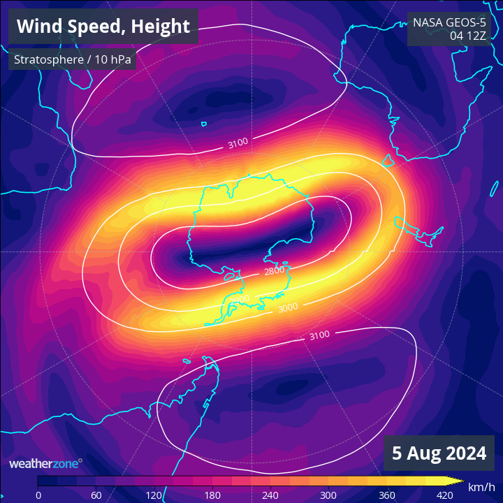
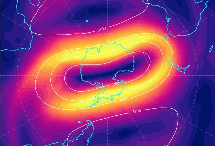
Image: A top-down view of the stratospheric polar vortex in early August 2024. This image shows wind speed at the 10hPa level of the atmosphere, which is about 30km above the surface. The polar vortex is elongated and its centre has been displaced from the South Pole, which is the result of polar stratospheric warming during July.
What causes the polar vortex to weaken abnormally?
The year-to-year variability of polar vortex behaviour in both the Northern and Southern Hemispheres is an active area of research. Scientists are still learning why the polar vortex is strong some years and much weaker in other years, and how these changes influence weather around the world.
One phenomenon that can disrupt the polar vortex is an event called sudden stratospheric warming (SSW), which occurs when forcing from the troposphere causes a rapid increase in temperature and a decrease in wind speed in the polar stratosphere.
The term sudden stratospheric warming (SSW) refers to an abrupt increase in air temperature high above either of Earth’s polar regions, typically of the magnitude of tens of degrees Celsius in a few days.
While sudden stratospheric warming events happen frequently in the Northern Hemisphere, they have only been observed a handful of times in the Southern Hemisphere.
How does the polar vortex affect Australia?
The polar vortex has little direct influence on Australian weather when it is strong and well-established. It also has little influence on hemispheric weather patterns during summer when it is in a seasonally weakened state.
However, a weakened polar vortex can have a big influence on weather patterns across the Southern Hemisphere and Australia.
When the stratospheric polar vortex weakens and changes shape, it can cause the tropospheric polar vortex to also weaken, become distorted, and sometimes displace its centre. A weakened polar vortex in the Southern Hemisphere usually causes nodes of polar air to spread away from Antarctica. These polar air masses can affect the weather in Australia, New Zealand, South America and Africa, and other islands in the Southern Hemisphere’s mid-latitudes.
It’s important to note that a weaker polar vortex does not mean cold weather everywhere in the Southern Hemisphere’s mid-latitudes. Some places typically get colder, wetter and windier when the vortex is weak, while others can see more dry and abnormally warm weather. The influence of a weakened vortex also varies from season to season.
For Australia, a weakened polar vortex typically makes the following weather more likely:
- More cold fronts and low pressure systems over southern Australia.
- Increased rainfall and snow potential in southwest and southeast Australia in winter.
- Less rainfall in Australia’s southeast and east during spring and summer.
- Greater chance of heat extremes in spring and summer for southern Australia.
- Stronger winds in the southern half of Australia.
A strong SSW event led to a weakened polar vortex in 2019 and played a role in causing abnormally dry and warm weather in eastern and southeastern Australia during spring and early summer. These conditions were a part of the reason some parts of the country experienced such prolific bushfires during the Black Summer of 2019/20.
Stratospheric warming was detected above Antarctica in July this year and there have been clear signs that this stratospheric warming has been influencing weather patterns in the troposphere into early August. It’s too early to know how this year’s stratospheric warming will impact Australia’s weather in spring and summer, although meteorologists will be keeping a close eye on the polar vortex in the coming months.
Weatherzone provide detailed seasonal updates to clients, with the information above plus more, to find out more visit our contact page or email us at apac.sales@dtn.com.


