
Despite a brief cool spell early in the month which included Sydney’s wettest September day in 146 years, the harbour city has recorded its second-warmest September since records were first kept in 1858.
In September 2025:
- Sydney’s average maximum was 23.5°C, which was around 3.3°C above the long-term average of 20.2°C.
- Sydney’s average minimum was 13.1°C, which was around 1.9°C above the long-term average of 11.2°C.
Only September 2013 was warmer than September 2025 in Sydney for both maximums and minimums, while 2023 was slightly hotter than this year for maximums.
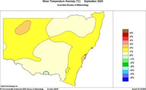
Image: Mean temperature anomalies across NSW during September 2025. Source: Bureau of Meteorology.
Why was September 2025 so warm?
In addition to the underlying influence of the warming climate, Sydney’s weather was also impacted by the Sudden Stratospheric Warming (SSW) over Antarctica.
The SSW is a weakening of the polar vortex which in turn leads to a negative Southern Annular Mode (SAM). This tends to produce more frequent spells of warm, windy conditions on the NSW coast.
What about Sydney temperatures and rainfall in other months this year?
Rainfall:
- Sydney has had a wet year thus far in 2025, with seven of the nine months seeing above-average rainfall.
- August was exceptionally wet with 389.6mm (nearly five times the long-term monthly average). It rounded out the city’s wettest winter in 18 years.
- Sydney exceeded its long-term annual rainfall average of 1222.6mm during the soggy 2025 August.
- Five of the last six years have now seen above-average rainfall in Sydney, including the record-breaking year of 2022.
Temperatures:
- Wet weather tends to go hand-in-hand with slightly cooler-than-average days, but despite its relatively high rainfall, Sydney has seen above-average maximums in each month of 2025 to date.
- Sydney’s minimums have been above average in eight of the nine months so far this year. The exception was June, when overnight lows were around half a degree below average.
More warm and dry weather to come for Sydney
Continued impacts of this Sudden Stratospheric Warming led negative South Annular Mode will promote warm and dry westerly winds moving into eastern NSW in the coming week, with a forecast of around 27°C today (Thursday), and around 29-30°C on at least 5 days between Sunday and Friday next week.
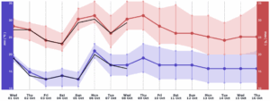
Image: DTN’s 14-day temperature forecast (red and blue) and BoM’s 7-day forecast (black) for Sydney as seen on DTN APAC’s Energyzone dashboard.
Hot and dry winds are bringing periods of elevated fire danger ratings in the coming week with enhanced curing from the past dry weeks.
DTN APAC has grown to become the outright leader within the Australian energy market, serving wind, solar, hydro, trading, utilities and network companies.
You can’t control the weather, but you can gain precision insights to optimise your response. What lights us up is providing your energy business with tailored weather information to reduce your risk and keep you moving ahead of the curve.
Our services cover all aspects – from wind and solar generation to demand forecasts, wholesale markets to retail so, no matter where your company sits, we have solutions for you. We have worked closely with market participants to create products that meet the evolving needs of the sector, aiming to increase safety and profitability for our customers.
Your customisable Energyzone interface can assess heat/heatwave potential from 14 days out to 12 months. It allows you to benefit from specialised indices for CDD/HDD/apparent temperature/sunshine hours to help accurately predict the demand for electricity. This, along with high-resolution modelling and local knowledge, gives you the most precise information available to make the critical decisions that bolster your production.
Benefit from the timely delivery of accurate weather information, allowing informed and effective decision-making.
Learn more about our large range of industry leading products and services or email us at sales.apac@dtn.com
Thumbnail image source: iStock / zetter


