Prosper in a dynamic world
Search

Sydney ends near-record run below 30 degrees

Sydney has just reached 30ºC for the first time in 11 months, ending its second longest run of days below 30ºC on record.

The temperature at Sydney’s Observatory Hill weather station, located near the southern end of the Harbour Bridge, surpassed 30ºC at 2:16pm on Wednesday.

While 30ºC days are not uncommon in Sydney during summer, days this hot have been scarce during the past year thanks to La Niña, abnormally prevalent easterly winds, abundant cloud and prolific rain.

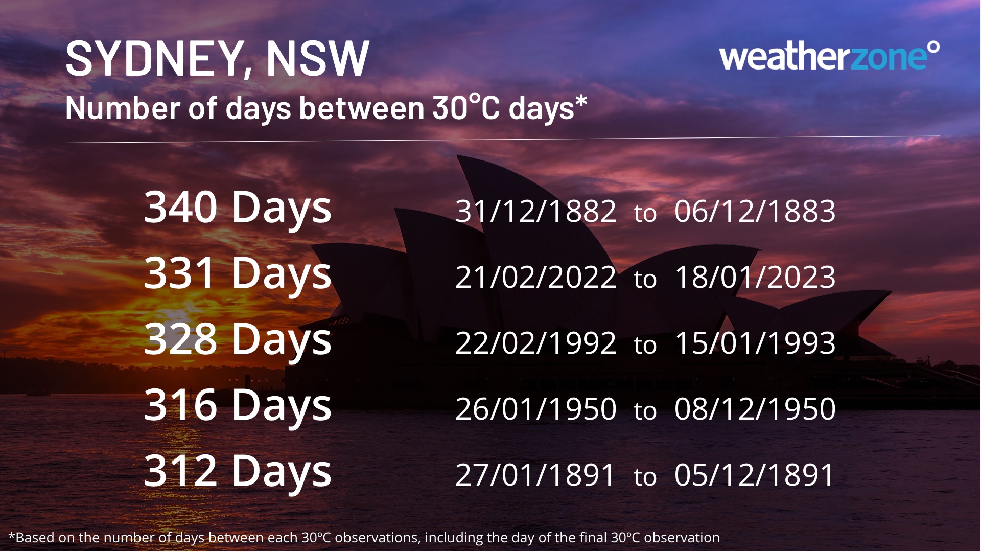
Prior to today, Sydney’s last day above 30ºC was on February 21, 2022, meaning the city just had 331 days between temperatures over 30ºC.

This is the city’s second longest gap between 30ºC days in records dating back to 1859. The only longer period between 30ºC days lasted for 340 days, between December 31, 1882, and December 6, 1883.

Sydney ends near-record run below 30 degrees

This prolonged and unusual absence of hot days in Sydney also saw the city fail to reach 32ºC at all in 2022, which was a new record. This coincided with Sydney’s wettest year on record, with the city amassing 2530 mm in 2022 to beat the previous record of 2194 mm in 1950.

Considering Sydney’s near-record run of days below 30ºC in the broader context of climate change makes it an even more impressive feat for the city. Observations from Observatory Hill show that the city’s mean annual maximum temperature has increased by around 1ºC between 1910 and 2021.

DTN APAC provides accurate temperature forecasts as far as 14-days in advanced through our Opticast system. To find out more, please email us at apac.sales@dtn.com.

Latest news

Satisfy your weather obsession with these news headlines from around the nation, and the world.

DTN Dangerous Thunderstorm Alerts in action with severe thunderstorms disrupting Perth industries

Severe thunderstorms impacted southwest WA and the Perth region on Sunday, December 14, 2025, triggering Dangerous Thunderstorm Alerts (DTA) by DTN for industries and businesses in the region. DTN operates Dangerous Thunderstorm Alerts (DTA) which alert businesses and industries to thunderstorms based on intensity and movement. These alerts provide advanced notice of thunderstorms moving into […]

How Australian East Coast port and maritime operations could be disrupted by tropical cyclones over the next two weeks

Port and maritime operations across Australia’s East Coast could be disrupted by increased tropical cyclone activity in the Coral Sea and southwest Pacific Ocean over the next two weeks. Meteorologists reference a large selection of Numerical Weather Prediction (NWP) models to forecast weather. A number of these NWP models are forecasting the development of tropical […]

Extreme fire danger and severe heatwave conditions spreading across SA, Victoria and NSW

Hot, dry and windy weather causing elevated fire danger and severe heatwave conditions are sweeping across southeastern Australia over the next three days, driving high energy demand and disruption to operations. Clear skies associated a large and slow-moving high pressure system have allowed hot air to build up over parts of northern, western and central […]

Heightened bushfire risk during the 2025-26 summer for WA, Victoria and NSW in latest AFAC Outlook

The Australian and New Zealand Council for fire and emergency services (AFAC) identified western and southern WA, Victoria and inland NSW as key regions that are at risk of heightened bushfire risk this summer. Parts of Australia have experienced severe soil moisture and rainfall deficiencies over the past months and years, while high fuel loads […]