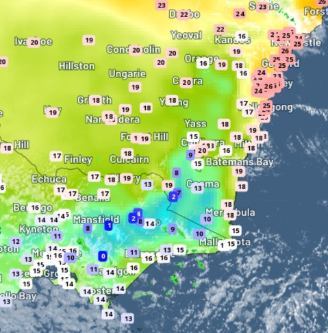
It’s been one of those days when Australia’s two largest cities could hardly have been more different in terms of weather.
Never mind the tedious old arguments about the food, coffee, culture, sport, traffic, scenery and the rest of it in the two cities. On this autumn Wednesday, Melbourne feels like winter while Sydney feels like summer.
At 1 pm:
- Melbourne was shivering in just 13.1°C
- Sydney was basking in 24.6°C
At 3 pm:
- Melbourne had warmed up to 16.3°C with its likely high for the day of 16.6°C achieved a few minutes later
- Sydney was sitting on a very balmy 25.6°C, having reached its likely maximum of 26.3°C just before 2 pm
We wrote earlier this Wednesday morning about the cold front that whipped through Tasmania and southern Victoria overnight, and how its effects would be limited further north.
Cooler air will reach Sydney a little later, dropping the late afternoon temperature by several degrees within a few minutes, and lowering the maximum to 23°C on Anzac Day.

But the 3 pm live temperature chart above showed that the Sydney basin remained under the influence of warm northwesterly winds until well into the afternoon, even as much cooler temps were evident across the rest of southern and central NSW, as well as the whole of Victoria.
Interestingly, Sydney’s average maximum in its hottest month of January is 26.0° so today’s top temperature has exceeded that mark.
OpticastTM V5 is Weatherzone’s cloud-based, consensus forecasting solution that delivers precise weather data to your business, both nationally and globally.
Independently verified to significantly outperform other industry models, Opticast gives you a strategic advantage if weather impacts your enterprise. Armed with the most accurate nowcasting and forecasting data, you can mitigate operational and safety risks, and plan to make the most of severe weather windows.
Opticast is powered by machine learning, intelligently adapting to the local conditions of your site area. Gain a world-leading forecasting system that rapidly responds to changing conditions.
We give you the foresight to make quick and powerful decisions when you need to protect your valuable team and assets, and ensure maximum productivity. For more information, please contact us at apac.sales@dtn.com.


