Prosper in a dynamic world
Search

Perth heatwave to ease by Christmas

Perth is in the middle of a five-day heatwave that is dredging up memories of last year’s searing Christmas heat. Thankfully, this week’s hot weather won’t be as intense as last year’s and it will end just in time for the Christmas break.

Perth endured an exceptionally hot Christmas in 2021, reaching 42.8ºC on December 25 to set a record for the highest Christmas Day temperature ever reliably recorded in an Australian capital city. This beat the previous record of 42.1ºC at Adelaide in 1888.

This week, heat has returned to Perth during the run into Christmas, with the city on track to register five consecutive days at or above 35ºC between Monday December 19 and Friday December 23.

These temperatures are about 5 to 6ºC above average for this time of year, which is enough for this to be classified as a low intensity heatwave. This is the lowest category on the Bureau of Meteorology’s three-tiered heatwave scale.

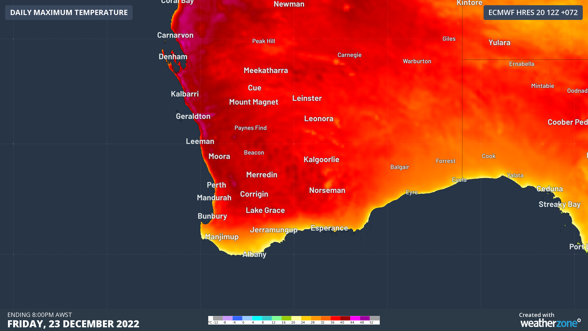
Image: Forecast maximum surface air temperature on Friday, December 23, 2022, according to the ECMWF-HRES model.

Unlike 2021, this year’s heatwave will end just before Christmas and the city is only forecast to reach tops of 32ºC on Christmas Eve, 31ºC on Christmas Day and 28ºC on Boxing Day.

In fact, if Perth remains below 32.5ºC on December 25 as is forecast, this will be the city’s coolest Christmas Day in seven years.

The coldest Christmas Day on record in Perth was in 1945, when the temperature only reached as high as 19.7ºC.

To find out more about Weatherzones 14-day temperature forecasts, please email us at apac.sales@dtn.com.

Latest news

Satisfy your weather obsession with these news headlines from around the nation, and the world.

October on track to beat hottest November on record for Sydney

Sydney’s days have been so hot this October that the city is currently on track to break the average maximum temperature record for November. Frequent westerly winds, a lack of cloud and rain, and repetitive bouts of hot air from inland NSW have caused Sydney’s daytime temperatures to run about 5°C above average so far […]

Widespread thunderstorms, extreme heat and high fire danger slam outback, southern and eastern Australia

Widespread severe thunderstorms, 45°C heat, extreme fire danger and total fire bans are impacting Australian industries, such as mining, aviation, transport, energy and insurance, this week. A 2,000 km long line of thunderstorms A nearly 2,000 km long line of thunderstorms could be seen on the DTN APAC Stormtracker dashboard on Tuesday. Image: Satellite imagery, […]

Extreme fire weather to hit NSW industries and businesses on Wednesday

A burst of record-challenging October heat and blustery winds will cause Extreme fire danger ratings and Total Fire Bans over parts of NSW on Wednesday, including Sydney. Clear skies and dry air have allowed intense heat to build over western NSW, southern Queensland and northern SA in the last few days. On Monday, the temperature […]

2025 southwest monsoon completes retreat from India

The 2025 Indian Southwest Monsoon that brings cooler temperatures and heavy flooding rainfall to Indian transport, mining and utility industries completed its retreat from India on October 16, 2025. As seen in the map below issued by the Indian Meteorological Department (IMD), the Indian Southwest Monsoon withdrew from the entirety of the Indian sub-continent on […]