A developing negative Southern Annular Mode (SAM) will influence weather patterns across the Australian region this week, favouring relatively cool and wet weather in the country’s south bringing increased wind energy generation, and much warmer conditions in the east and north driving higher energy demand.
Negative SAM emerging
Recent warming in the stratosphere high above Antarctica is causing a negative SAM pattern to develop in the southern hemisphere this week.
A negative SAM is associated with a northward shift in the belt of westerly winds that flows between Australia and Antarctica. During spring, a negative SAM pattern typically causes cold fronts and low pressure to deliver more rain in southern Australia, while high pressure systems centred further north cause drier and warmer weather across much of northern and eastern Australia.
This week’s weather patterns across Australia will reflect the developing negative SAM and promote the following conditions:
- Southern Australia can expect to see frequent showers and periods of relatively cool weather in predominantly west to southwesterly winds maintaining steady wind energy generation.
- Northern and Eastern Australia will be dry and warm to hot under the influence of high pressure and dry continental air masses, leading to surges in energy demand.
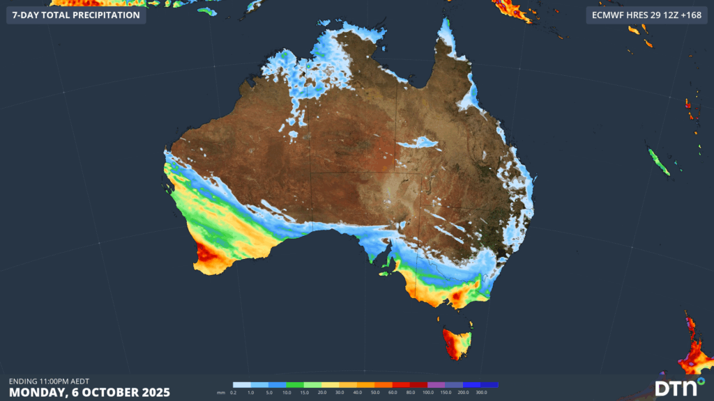
Image: Forecast accumulated rain this week, showing most of the rain falling over southern and southwestern Australia and indicating less wet weather in the north and east.
This week’s contrasting weather can be highlighted by comparing the forecasts across Australia’s southern and eastern cities.
Brisbane and Sydney are both in the area of eastern Australia that will see plenty of warm and dry weather this week. Brisbane is forecast to reach the low to mid-thirties from Wednesday to Friday, peaking at 34 to 35°C on Thursday. Sydney will also reach the high twenties from Tuesday to Thursday.
By contrast, Melbourne and Adelaide will see several days only reaching the mid to high teens this week, with showers also likely on multiple days.
Thursday will be a particularly contrasting day across southeastern and eastern Australia, with the following forecast maximum temperatures:
- Brisbane: 34°C
- Sydney: 28°C
- Canberra: 19°C
- Adelaide: 17°C
- Melbourne: 16°C
- Hobart: 17°C
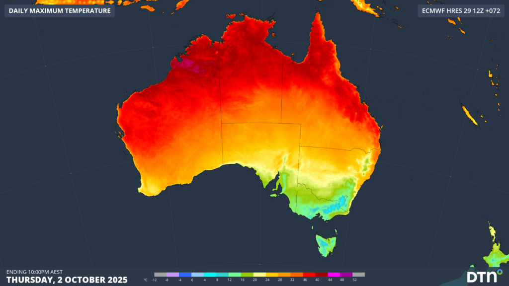
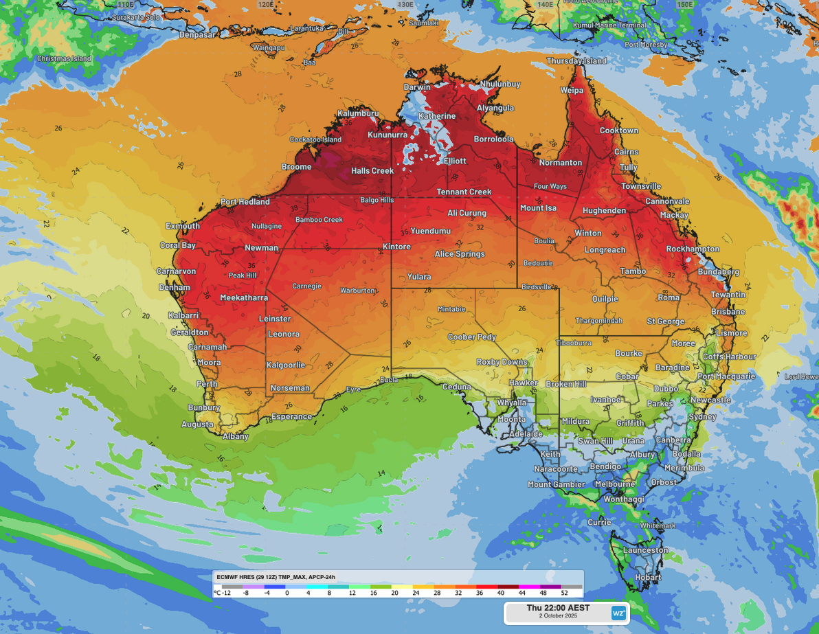
Image: Forecast maximum temperature on Thursday, October 2, 2025, showing warm air over northern and eastern Australia and cooler temperatures over the country’s south.
Northern Australia will see heat building up under this week’s weather pattern, with temperatures likely to reach the low forties in parts of the Kimberley, Pilbara and Top End. This won’t be the first time temperatures have exceeded 40°C in Australia this spring, but it has a good chance of being the country’s hottest weather so far this season.
The combination of heat and dry weather in northern and eastern Australia will also increase the potential for fires this week, with high fire danger likely over broad areas of WA, the NT, Queensland and NSW.
DTN APAC has grown to become the outright leader within the Australian energy market, serving wind, solar, hydro, trading, utilities and network companies.
You can’t control the weather, but you can gain precision insights to optimise your response. What lights us up is providing your energy business with tailored weather information to reduce your risk and keep you moving ahead of the curve.
Our services cover all aspects – from wind and solar generation to demand forecasts, wholesale markets to retail so, no matter where your company sits, we have solutions for you. We have worked closely with market participants to create products that meet the evolving needs of the sector, aiming to increase safety and profitability for our customers.
Your customisable Energyzone interface can assess heat/heatwave potential from 14 days out to 12 months. It allows you to benefit from specialised indices for CDD/HDD/apparent temperature/sunshine hours to help accurately predict the demand for electricity. This, along with high-resolution modelling and local knowledge, gives you the most precise information available to make the critical decisions that bolster your production.
Benefit from the timely delivery of accurate weather information, allowing informed and effective decision-making.
Learn more about our large range of industry leading products and services or email us at sales.apac@dtn.com


