Melbourne has already reached 20.4°C just before midday this Thursday, on the way to a top that will likely reach 22°C, after a high of 21.9°C on Wednesday.
So we’re looking at two consecutive winter days around 22°C, which sounds like something the late great cricket commentator Richie Benaud would have said.
Not since 2021 has Melbourne seen a winter day of 22 degrees or higher, which is some seven degrees above the average August maximum of 15°C.
This weather in #Melbourne is nuts. The #magnolias are looking magnificent. The hay fever is not so magnificent pic.twitter.com/dOfqSSDHZi
— Brian The Ruminator (@lynchonswan) August 14, 2024
And Melbourne is hardly alone in experiencing a taste of spring today:
- Mildura, in Victoria’s far northwest, is heading for 26°C.
- And not forgetting South Australia, Adelaide is on the way to 24°C.
- Oodnadatta, the northern SA town famous for co-holding Australia’s all-time high temp record of 50.7°C, is heading for 31°C, its first 30-degree day this winter.
The current winter warm spell is being caused by persistent northerly winds funnelling mild air from the interior of the continent southwards.
By the weekend, the cold front and associated low pressure system currently in the Great Australian Bight will have tracked east, swinging winds to the west and southwest in Melbourne, with max temps dropping to near average.
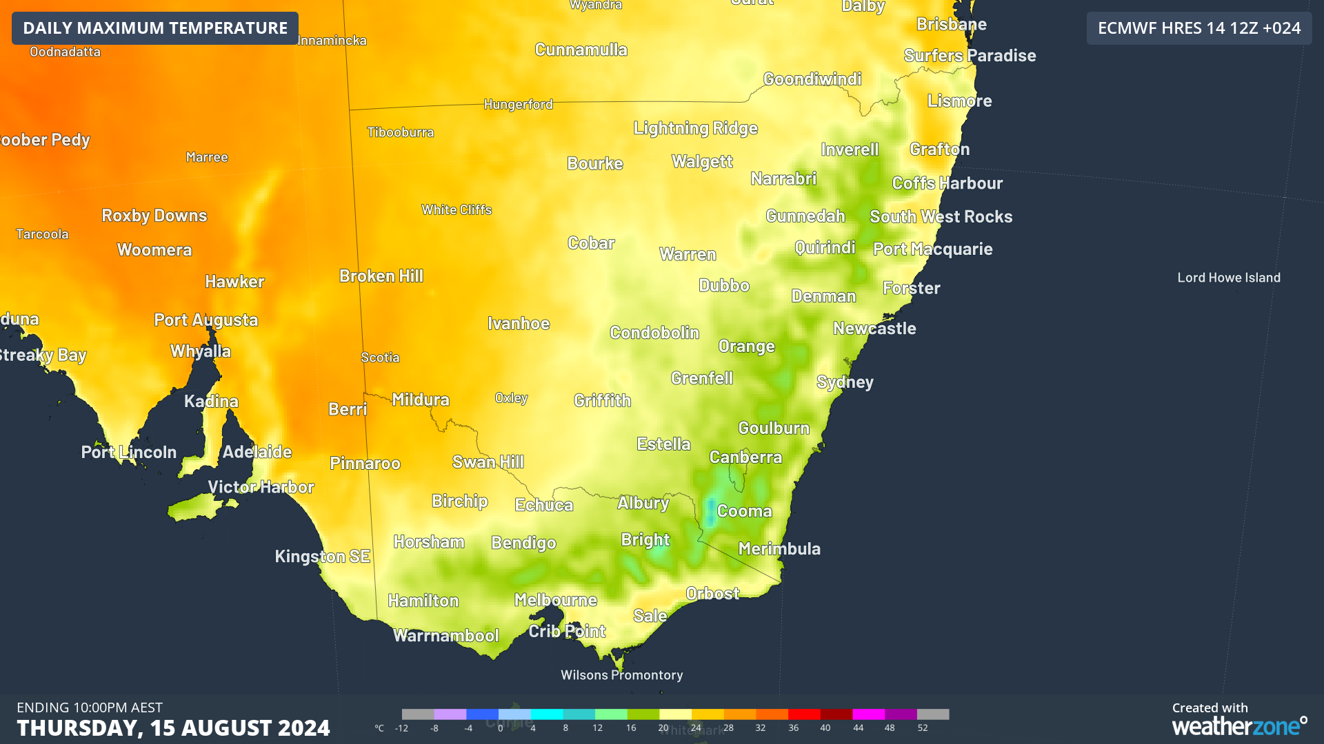
Image: Max temps for this Thursday in SE Australia.
This weekend’s influx of cooler air will be neither particularly strong nor long-lasting, with top temps rising to the high teens again in both Adelaide and Melbourne in the new week.
Current models then suggest another burst of cooler air later next week which will make southern parts of the continent feel wintry again.
Beyond that, the BoM predicts the strong likelihood of warmer than usual days and nights across most of Australia from September through the end of November.
So we can’t quite draw the curtains on winter 2024 quite yet, but for Melbourne, August 2024 will likely end up being significantly warmer-than-average overall, after both June and July temps were close to the long-term average.
As things stand halfway through the month, August maximums in Melbourne have been almost three degrees higher than the long-term average.
Weatherzone Business has grown to become the outright leader within the Australian energy market, serving wind, solar, hydro, trading, utilities and network companies.
You can’t control the weather, but you can gain precision insights to optimise your response. What lights us up is providing your energy business with tailored weather information to reduce your risk and keep you moving ahead of the curve.
Our services cover all aspects – from wind and solar generation to demand forecasts, wholesale markets to retail so, no matter where your company sits, we have solutions for you. We have worked closely with market participants to create products that meet the evolving needs of the sector, aiming to increase safety and profitability for our customers.
Benefit from the timely delivery of accurate weather information, allowing informed and effective decision-making. To find out more visit our contact page or email us at apac.sales@dtn.com.


